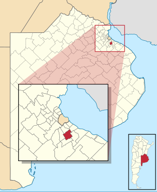
Almirante Brown is a partido of the Buenos Aires Province, Argentina, located at the south of the Gran Buenos Aires urban area, at coordinates 34°47′S58°24′W.
Cabo Rojo is a barrier of quartzite sand deposited adjacent to the coast of the Mexican state of Veracruz, about 55 km (34 mi) south of the city of Tampico, Tamaulipas. It encloses the brackish lagoon called Laguna de Tamiahua. It is located in the municipalities of Ozuluama de Mascareñas and Tamiahua.
Mikkelsen Bay is a bay, 15 nautical miles wide at its mouth and indenting 10 nautical miles, entered between Bertrand Ice Piedmont and Cape Berteaux along the west coast of Graham Land, Antarctica.
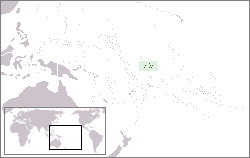
Carondelet Reef is a horseshoe-shaped reef, presumably a submerged atoll formation, of the Phoenix Islands, also known as the Rawaki Islands, in the Republic of Kiribati. It is located 106 kilometres southeast of Nikumaroro, at 05°34′S173°51′W, and has a least depth of 1.8 metres (5.9 ft). It is reported to be approximately 1.5 kilometres (0.9 mi) in length. The sea occasionally breaks over it.
Hontangas is a municipality located in the province of Burgos, Castile and León, Spain. According to the 2004 census (INE), the municipality has a population of 134 inhabitants. In 2009, there is 123 inhabitants.
The Jaeger Table is the ice-covered summit plateau of Dufek Massif, in the Pensacola Mountains of Antarctica, rising to 2,030 metres (6,660 ft) at Worcester Summit.

Rondos District is one of seven districts of the province Lauricocha in the Huanuco Region of Peru. The district had an area of 172.7 square kilometres (66.7 sq mi) and a population of 3,798 in 2017. The town of Rondos is the capital of the district and had a population of 826 in 2017. The town is situated on a mesa overlooking the junction of the Lauricocha and Nupe Rivers, 250 metres (820 ft) in elevation below Rondos, to form the Marañon River. The headwaters of both the Lauricocha and Nupe rivers have been proposed as sources of the Amazon River.
Lagunillas, San Luis Potosí is a town and municipality in the Mexican state of San Luis Potosí in central Mexico.
Batavia (San Luis) is a village and municipality in San Luis Province in central Argentina.
La Punta is a village and municipality in San Luis Province in central Argentina.
Nahuel Mapá is a village and municipality in San Luis Province in central Argentina.
Arauco (La Rioja) is a municipality and village in La Rioja Province in northwestern Argentina.
San José Norte is a town and municipality in Catamarca Province in northwestern Argentina.
Bryan Coast is that portion of the coast of Antarctica along the south shore of the Bellingshausen Sea between Pfrogner Point and the northern tip of the Rydberg Peninsula. To the west is Eights Coast, and to the east is English Coast.
The Davis Peninsula is an elongated ice-covered peninsula, 3 nautical miles (6 km) wide, between Reid Glacier and Northcliffe Glacier. It was discovered in November 1912 by the Australasian Antarctic Expedition under Mawson, who named it for Captain John King Davis.
Planet Heights is a series of summits running along an ice-free ridge, extending 24 nautical miles (44 km) in a north-south direction between the southernmost extremity of the LeMay Range and George VI Sound in the east part of Alexander Island, Antarctica. Many landforms and nearby features are named in association with this mountain range; some of these include landforms named after astronomers, satellites, planets and other things related to astrology and astrophysics. The mountain range was first mapped from air photos taken by the Ronne Antarctic Research Expedition (RARE), 1947–48, by Searle of the Falkland Islands Dependencies Survey (FIDS) in 1960. Named by the United Kingdom Antarctic Place-Names Committee (UK-APC) from association with the nearby glaciers named for planets of the Solar System. The only planet that is not featured in any of these glaciers is the planet Earth, as there are no glaciers named "Earth Glacier" and this glacier does not exist.

The Goodenough Glacier is a broad sweeping glacier to the south of the Batterbee Mountains, flowing from the west shore of Palmer Land, Antarctica, into George VI Sound and the George VI Ice Shelf.

Los Titanes is a seaside resort in Canelones Department, Uruguay.
