
Tides are the rise and fall of sea levels caused by the combined effects of the gravitational forces exerted by the Moon and are also caused by the Earth and Moon orbiting one another.

An amphidromic point, also called a tidal node, is a geographical location where there is little or no difference in sea height between high tide and low tide; it has zero tidal amplitude for one harmonic constituent of the tide. The tidal range for that harmonic constituent increases with distance from this point, though not uniformly. As such, the concept of amphidromic points is crucial to understanding tidal behaviour. The term derives from the Greek words amphi ("around") and dromos ("running"), referring to the rotary tides which circulate around amphidromic points. It was first discovered by William Whewell, who extrapolated the cotidal lines from the coast of the North Sea and found that the lines must meet at some point.

A jetty is a structure that projects from land out into water. A jetty may serve as a breakwater, as a walkway, or both; or, in pairs, as a means of constricting a channel. The term derives from the French word jetée, "thrown", signifying something thrown out.
Slack tide or slack water is the short period in a body of tidal water when the water is completely unstressed, and there is no movement either way in the tidal stream. It occurs before the direction of the tidal stream reverses. Slack water can be estimated using a tidal atlas or the tidal diamond information on a nautical chart. The time of slack water, particularly in constricted waters, does not occur at high and low water, and in certain areas, such as Primera Angostura, the ebb may run for up to three hours after the water level has started to rise. Similarly, the flood may run for up to three hours after the water has started to fall. In 1884, Thornton Lecky illustrated the phenomenon with an inland basin of infinite size, connected to the sea by a narrow mouth. Since the level of the basin is always at mean sea level, the flood in the mouth starts at half tide, and its velocity is at its greatest at the time of high water, with the strongest ebb occurring conversely at low water.
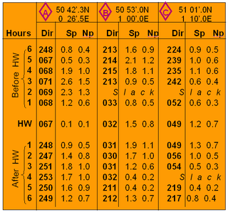
Tidal diamonds are symbols on British admiralty charts and others that indicate the direction and speed of tidal streams.
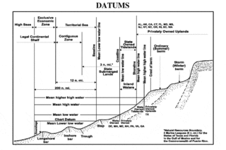
A chart datum is the water level surface serving as origin of depths displayed on a nautical chart and for reporting and predicting tide heights. A chart datum is generally derived from some tidal phase, in which case it is also known as a tidal datum. Common chart datums are lowest astronomical tide (LAT) and mean lower low water (MLLW). In non-tidal areas, e.g. the Baltic Sea, mean sea level (MSL) is used. A chart datum is a type of vertical datum and must not be confused with the horizontal datum for the chart.

Tide tables, sometimes called tide charts, are used for tidal prediction and show the daily times and levels of high and low tides, usually for a particular location. Tide heights at intermediate times can be approximated by using the rule of twelfths or more accurately calculated by using a published tidal curve for the location. Tide levels are typically given relative to a low-water vertical datum, e.g. the mean lower low water (MLLW) datum in the US.
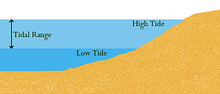
Tidal range is the difference in height between high tide and low tide. Tides are the rise and fall of sea levels caused by gravitational forces exerted by the Moon and Sun, by Earth's rotation and by centrifugal force caused by Earth's progression around the Earth-Moon barycenter. Tidal range depends on time and location.

Seven: A Suite for Orchestra is the fourth studio album, and the first classical solo album by Genesis keyboardist Tony Banks. It was released by Naxos Records in 2004. The suite is performed by the London Philharmonic Orchestra and conducted by Mike Dixon. Banks plays piano on "Spring Tide", "The Ram" and "The Spirit of Gravity".

Chanonry Point lies at the end of Chanonry Ness, a spit of land extending into the Moray Firth between Fortrose and Rosemarkie on the Black Isle, Scotland.

Aurora is the second album by post-rock band Esmerine. It was released by Madrona Records in 2005.

The Yealm is a river in Devon in England that rises 430 m (1,410 ft) above sea level on the Stall Moor mires of south Dartmoor and travels 12 miles (19 km) to the sea, passing through Cornwood, Lee Mill and Yealmpton, a mid-sized village with a population of c.2,000 which is its largest settlement, before reaching its estuary which forms a ria bounded on its western side by Wembury. A deep inlet of this ria forms the waterfront to Newton Ferrers and Noss Mayo on its eastern side.

Bow Locks No. 20 is a set of bi-directional locks in Bromley-by-Bow in the London Borough of Tower Hamlets and Newham. The locks link the tidal Bow Creek to the River Lee Navigation, which is a canalised river. These locks were first built in 1850 and then rebuilt in 1930, at the same time as the Prescott Channel was cut nearby. At high tide, the tide from Bow Creek formerly flowed through Bow Locks, to raise the level of the canals, such as the Limehouse Cut. In 2000, these locks were modified to keep the tide out, to reduce silting in the canal system.
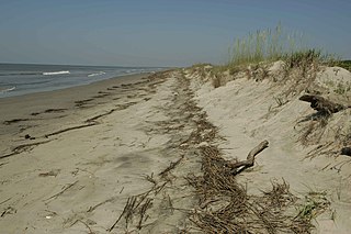
The wrack zone or wrack line is a coastal feature where organic material and other debris are deposited at high tide. This zone acts as a natural input of marine resources into a terrestrial system, providing food and habitat for a variety of coastal organisms.
Dahej is a cargo port situated on the South-west coast of Gujarat, India in Bharuch district. There is 17.5 million tonnes per year capacity LNG terminal operated by Petronet in Dahej.
A tidal atlas or a tidal stream atlas is used to predict the direction and speed of tidal currents.

In astronomy, a syzygy is a roughly straight-line configuration of three or more celestial bodies in a gravitational system.
A tidal bundle is a sedimentary structure that forms in tidal areas as a result of spring and neap tides.
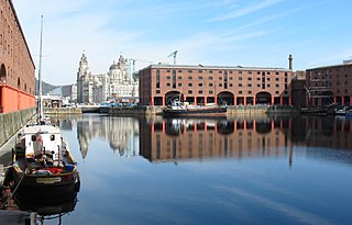
A floating dock, floating harbour or wet dock is a dock alongside a tidal waterway which maintains a 'constant' level, despite the changing tides.
Sarnia: An Island Sequence is a set of three pieces for piano solo composed in 1940–41 by John Ireland.