Neath is a nigh-coastal town in the South Wales Valleys.
Neath may also refer to:
Neath is a nigh-coastal town in the South Wales Valleys.
Neath may also refer to:

Aberavon was a constituency in Wales in the House of Commons of the Parliament of the United Kingdom. It was represented from 1922 until 2024 by the Welsh Labour Party. It included the town of Aberavon, although the largest town in the constituency was Port Talbot.

Port Talbot is a town and community in the county borough of Neath Port Talbot, Wales, situated on the east side of Swansea Bay, approximately eight miles from Swansea. The Port Talbot Steelworks covers a large area of land which dominates the south east of the town. It is one of the biggest steelworks in the world, but has been under threat of closure since the 1980s. The population was 31,550 in 2021, comprising about a fifth of the 141,931 population of Neath Port Talbot.

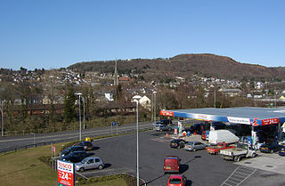
Neath is a market town and community situated in the Neath Port Talbot County Borough, Wales. The town had a population of 50,658 in 2011. The community of the parish of Neath had a population of 19,258 in 2011. Historically in Glamorgan, the town is located on the River Neath, seven miles east-northeast of Swansea.

Neath Port Talbot is a county borough in the south-west of Wales. Its principal towns are Neath, Port Talbot, Briton Ferry and Pontardawe. The county borough borders Bridgend County Borough and Rhondda Cynon Taf to the east, Powys and Carmarthenshire to the north; and Swansea to the west.

West Glamorgan is a former administrative county in South Wales. It is now a preserved county.

The A465 is a trunk road that runs from Bromyard in Herefordshire, England to Llandarcy near Swansea in south Wales. The western half in Wales is known officially as the Neath to Abergavenny Trunk Road, but the section from Abergavenny to the Vale of Neath is more commonly referred to as the Heads of the Valleys Road because it links the northern heads of the South Wales Valleys. Approximately following the southern boundary of the Brecon Beacons National Park, the Ordnance Survey Pathfinder guide describes it as the unofficial border between rural and industrial South Wales. The A465 provides an alternative route between England and the counties in South West Wales and to the ferries to Ireland.

Ystradfellte is a village and community in Powys, Wales, about 6 miles (10 km) north of Hirwaun, with 556 inhabitants. It belongs to the historic county of Brecknockshire (Breconshire) and the Fforest Fawr area of the Brecon Beacons National Park, beside the Afon Mellte river. The village is linked by minor roads with Heol Senni to the north and the A4059 north of Penderyn, and with Pontneddfechan, which lies in the community, at the head of the Vale of Neath to the south.

Briton Ferry is a town and community in the county borough of Neath Port Talbot, Wales. The Welsh name may indicate that the church, llan, is protected from the wind, awel. Alternatively, Sawel may be a derivative of Saul, St Paul's earlier name, who, supposedly, once landed at Briton Ferry. An alternative Welsh name unused today is Rhyd y Brython, a direct translation of Briton Ferry. The Normans referred to the River crossing as La Brittonne and Leland in 1540 as Britanne Fery.
Pontardawe is a town and a community in the lower Swansea Valley. it had a population of approximately 7,172 in the 2021 Census for Pontardawe Parish, and forms part of the county borough of Neath Port Talbot.

Neath was a constituency in Wales represented in the House of Commons of the UK Parliament from 1918 to 2024.

Crynant is a village and community in the Dulais Valley in Wales. It lies 7¾ miles north-east from the town of Neath in Neath Port Talbot, situated between the mountains of Mynydd Marchywel to the west, Hirfynydd to the east and Mynydd y Drum to the north.
Cymmer is a small village in the community of Cymer and Glyncorrwg, in Neath Port Talbot in Wales, set on a hillside in the Afan Valley near the confluence of the River Afan and the River Corrwg. In 2001, Cymmer had a population of 2,883.
Cimla is a village and suburb of the town of Neath in the county borough of Neath Port Talbot, Wales. It is set high up on a hill. It is pronounced Kim-la. The Welsh language spelling is Cymla, pronounced the same way. Its meaning is a place with common land, which it presumably was until industrial expansion led to its being covered with housing.

Blaengwrach is a community near Glynneath and Resolven in the county borough of Neath Port Talbot, Wales. It is also the name of an electoral ward of Neath Port Talbot county borough, which is a larger area than the Community. The principal settlement is Cwmgwrach, a village on the south side of the Neath valley, of which the eastern end is called Blaengwrach, which sometimes causes confusion.

Glyncorrwg is a village in the Afan Valley, in southern Wales.
Neath is a constituency of the Senedd. It elects one Member of the Senedd by the first past the post method of election. Also, however, it is one of seven constituencies in the South Wales West electoral region, which elects four additional members, in addition to seven constituency members, to produce a degree of proportional representation for the region as a whole.

Penwyllt is a hamlet located in the upper Swansea Valley in Powys, Wales, lying within the Brecon Beacons National Park.
Resolven is and electoral ward of Neath Port Talbot county borough, Wales. Resolven is made up of the parishes of Resolven and Clyne and Melincourt.

The West Wales Premier League is a football league in Wales, at tier 4 of the Welsh Football Pyramid in South West Wales under the control of the West Wales Football Association. The league consists of teams having their grounds and headquarters West of a line drawn from Briton Ferry, Neath, northwards to Glynneath, and then again northwards to the boundary line of the South Wales Football Association. It offers promotion opportunities to the Ardal Leagues, at tier 3 of the Football Association of Wales pyramid.