Neos Panteleimonas

Last updated
View of Neos Panteleimonas, with the Olympus in the background. Panteleimon olimpos.jpg
View of Neos Panteleimonas, with the Olympus in the background.

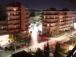
Neos Panteleimonas (Greek : Νέος Παντελεήμονας) is a settlement of the former municipality of East Olympos, which is part of the municipality of Dio-Olympos, in the Pieria regional unit, Central Macedonia, Greece.

Greek language language spoken in Greece, Cyprus and Southern Albania

Greek is an independent branch of the Indo-European family of languages, native to Greece, Cyprus and other parts of the Eastern Mediterranean and the Black Sea. It has the longest documented history of any living Indo-European language, spanning more than 3000 years of written records. Its writing system has been the Greek alphabet for the major part of its history; other systems, such as Linear B and the Cypriot syllabary, were used previously. The alphabet arose from the Phoenician script and was in turn the basis of the Latin, Cyrillic, Armenian, Coptic, Gothic, and many other writing systems.

East Olympos Place in Greece

East Olympos, or Anatolikos Olympos, is a former municipality in Pieria regional unit, Greece. Since the 2011 local government reform it is part of the municipality Dio-Olympos, of which it is a municipal unit. The municipal unit has an area of 152.939 km2. Population 8,343 (2011). The seat of the municipality was in Leptokarya.

Contents

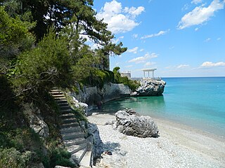
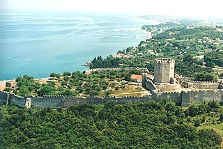
Neos Panteleimonas is a settlement built on the foothills of Mount Olympos by the seaside. Its privileged region offers endless view to the sea and the Castle of Platamon. By car, the Old Panteleimon is 400 km from Athens and 110 km from Thessaloniki. It is worth visiting the museum and the archeological site of Dion.

Athens Capital and largest city of Greece

Athens is the capital and largest city of Greece. Athens dominates the Attica region and is one of the world's oldest cities, with its recorded history spanning over 3,400 years and its earliest human presence starting somewhere between the 11th and 7th millennium BC.

Thessaloniki City in Macedonia, Greece

Thessaloniki, also familiarly known as Thessalonica, Salonica or Salonika, is the second-largest city in Greece, with over 1 million inhabitants in its metropolitan area, and the capital of Greek Macedonia, the administrative region of Central Macedonia and the Decentralized Administration of Macedonia and Thrace. Its nickname is η Συμπρωτεύουσα, literally "the co-capital", a reference to its historical status as the Συμβασιλεύουσα (Symvasilévousa) or "co-reigning" city of the Eastern Roman (Byzantine) Empire, alongside Constantinople.

Dion, Pieria Place in Greece

Dion or Dio is a village and a former municipality in the Pieria regional unit, Greece. Since the 2011 local government reform, it is part of the municipality Dio-Olympos, of which it is a municipal unit. It is located at the foot of Mount Olympus at a distance of 17 km from the capital city of Katerini.

The beach is several kilometers and has lifeguards throughout the length, beach bars with umbrellas and sunbeds for which charge only a coffee or a drink that you provide. You can also visit the central square of the village for a tsipouro drink.

Tsipouro

Tsipouro is a pomace brandy from Greece and in particular Thessaly, Epirus, Macedonia, and the island of Crete. Tsipouro is a strong distilled spirit containing 40-45% alcohol by volume and is produced from the pomace. It comes in two types: pure and anise-flavoured.

Nearest places

Platamon Place in Greece

Platamon, or Platamonas, is a town and sea-side resort in south Pieria, Central Macedonia, Greece. Platamon has a population of about 2,000 permanent inhabitants. It is part of the Municipal unit of East Olympos of the Dio-Olympos municipality.

Neoi Poroi Place in Greece

Neoi Poroi is a coastal village of the Dio-Olympos municipality. Before the 2011 local government reform it was part of the municipality of East Olympos, of which it was a municipal district. The settlement of Neoi Poroi had a population of 733 inhabitants as of 2011. Neoi Poroi is a part of the community of Poroi. The main occupation in the village is tourism. A model development plan, has huge streets and squares.

See also

Related Research Articles

Evosmos Place in Greece

Evosmos is a suburb of the Thessaloniki Urban Area and was a former municipality in the regional unit of Thessaloniki, Greece. Since the 2011 local government reform it is part of the municipality Kordelio-Evosmos, of which it is the seat and a municipal unit. It has a land area of 9.927 square kilometres (3.833 sq mi) and its population is 74,686. Due to rapid development, the population has been growing fast. Most of the new development is taking place in the northern district of the municipality called Nea Politeia.

Gazi, Crete Place in Greece

Gazi is a town and a former municipality in the Heraklion regional unit of Crete in Greece. Since the 2011 local government reform it is part of the municipality Malevizi, of which it is a municipal unit. It lies 6 kilometres west of Heraklion, on the north coast of Crete. With 12,606 inhabitants, it was the seat of the municipality of Gazi, which comprised several nearby villages with a total population of 19,221 and an area of 95.81 square kilometres (36.99 sq mi).

Plomari Place in Greece

Plomari is a town and a former municipality on the island of Lesbos, North Aegean, Greece. Since the 2011 local government reform it is part of the municipality Lesbos, of which it is a municipal unit. It is the only sizable coastal settlement in the south, and the second largest town on Lesbos. The municipal unit of Plomari is the southernmost on Lesbos island and has a land area of 122.452 km² and a 2011 census population of 5,602. Its largest towns or villages are Plomári, the former municipal seat, Plagiá (529), Palaiochóri (314), Megalochóri (325), and Akrási (214).

Leptokarya Place in Greece

Leptokarya is a town in Pieria regional unit, Central Macedonia, Greece, former seat of East Olympos municipality, which is part of the municipality of Dio-Olympos. The distance from Katerini is 26 km and the population of the village was 4,225 inhabitants as of 2011.

Ardameri is a village in the regional unit of Thessaloniki of Greece, at the foot of Mount Chortiatis, on the site of the medieval settlement of Ardamerion (Αρδαμέριον).

Neos Marmaras small town in Greece

Neos Marmaras is a town on the Sithonia peninsula, in the Chalkidiki peninsula, Greece. In 2011, Neos Marmaras had 3,352 permanent residents; however, the summer-time population has been estimated at 20,000. The main industries are tourism, agriculture, and fishing. Situated on three shoreline hills, below the two mountains, Itamos and Tragoudeli, Neos Marmaras is located 125 kilometres (78 mi) from Thessaloniki, and 55 kilometres (34 mi) from Poligyros.

Platamon Castle fortification

The Platamon Castle, an important part of the history of Pieria, is a Crusader castle in northern Greece (Macedonia) and is located southeast of Mount Olympus, in a strategic position which controls the exit of the Tempe valley, through which passes the main road connecting Macedonia with Thessaly and southern Greece. The tower (donjon), which overlooks the highway, is an imposing medieval fortress.

Palaios Panteleimonas is a mountain village of the former municipality of East Olympos, which is part of the municipality of Dio-Olympos, in the Pieria regional unit, Central Macedonia, Greece.

Paralia Panteleimonos village in Greece

Paralia Panteleimonos is a settlement of the former municipal district of Panteleimonas, the former municipality of East Olympos, which belongs to the municipality of Dio-Olympos, and is one of the 16 total coast of the regional unit.

Skotina Place in Greece

Skotina is a rural settlement of the former municipality of East Olympos, itself part of the municipality of Dio-Olympos, in the Pieria regional unit, Central Macedonia, Greece.

Paralia Skotinas village in Greece

Paralia Skotinas is a seaside settlement which is part of the municipality of Dio-Olympos, in the Pieria regional unit, Central Macedonia, Greece. It is 6 κm from Leptokarya, 1 km from Paralia Panteleimonos (Castle) and 1κm from Skotina. In this point its view of the Castle of Platamon, is unique.

Vrontou, Pieria human settlement in Greece

Vrontou is a town of the former Municipality of Dio, which is part of the municipality of Dio-Olympos, in the Pieria regional unit, Central Macedonia, Greece, at an altitude of 120 meters, with 1,902 inhabitants. There are several medieval and post-medieval churches in Vrontou.

Aigani is a village and a community in the municipal unit of Kato Olympos, which is part of the municipality of Tempi in the Larissa regional unit, Thessaly, Greece. The community consists of the villages Aigani, Kastri-Loutro, Kato Aigani, Nea Mesangala and Papapouli. It is located at an altitude of 250 meters and 40 km both from the cities of Larissa and Katerini.

Nea Mesangala is a beach settlement of the community of Aigani, a former municipal district of Kato Olympos, which is part of the municipality of Tempi in the Larissa regional unit, Thessaly, Greece.

Kastri-Loutro is a settlement of the department of the beach of Aigani, a former municipal district of Kato Olympos, which is part of the municipality of Tempi in the Larissa regional unit, Thessaly, Greece.

Panteleimonas, Pieria Place in Greece

Panteleimonas is a community of the Dio-Olympos municipality. Before the 2011 local government reform it was part of the municipality of East Olympos, of which it was a municipal district. The 2011 census recorded 911 inhabitants in the community.

Panteley is a Slavic male name, derived from the Greek name Panteleimon, from παντελεία («panteleya»), meaning "perfection".

References

Coordinates: 40°00′11″N22°35′39″E / 40.00306°N 22.59417°E / 40.00306; 22.59417

Geographic coordinate system Coordinate system

A geographic coordinate system is a coordinate system that enables every location on Earth to be specified by a set of numbers, letters or symbols. The coordinates are often chosen such that one of the numbers represents a vertical position and two or three of the numbers represent a horizontal position; alternatively, a geographic position may be expressed in a combined three-dimensional Cartesian vector. A common choice of coordinates is latitude, longitude and elevation. To specify a location on a plane requires a map projection.