
Erie County is a highly populated county in the U.S. state of New York. As of the 2010 census, the population was 919,040. The county seat is Buffalo. The county's name comes from Lake Erie. It was named by European colonists for the regional Iroquoian language-speaking Erie tribe of Native Americans, who lived south and east of the lake before 1654.
Interstate 680 (I-680) is a major north–south auxiliary Interstate Highway in Northern California. It curves around the eastern cities of the San Francisco Bay Area from San Jose to Interstate 80 at Fairfield, bypassing cities along the eastern shore of San Francisco Bay such as Oakland and Richmond while serving others more inland such as Pleasanton and Concord.

The City of Manningham is a local government area in Victoria, Australia in the north-eastern suburbs of Melbourne and is divided into 12 suburbs, with the largest being Doncaster and Doncaster East. It comprises an area of 114 square kilometres and had a population of 116,255 in 2016.

The Shire of Yarra Ranges, also known as Yarra Ranges Council, is a local government area in Victoria, Australia, located in the outer eastern and northeastern suburbs of Melbourne extending into the Yarra Valley and Dandenong Ranges. It has an area of 2,469 square kilometres (953 sq mi), of which 3% is classified as urban. At the 2016 Australian census, it had a population of 149,537.

U.S. Route 219 is a spur of U.S. Route 19. It runs for 535 miles (861 km) from West Seneca, New York at an interchange with Interstate 90, to Rich Creek, Virginia, intersecting at U.S. Route 460. U.S. 219 is found in New York, Pennsylvania, Maryland, West Virginia, and Virginia. Much of the Route in West Virginia follows the old Indian warpath known as the Seneca Trail.

San Gregorio State Beach is a beach near San Gregorio, California, USA, south of Half Moon Bay. Part of the California State Park System, the beach lies just west of the intersection of California State Route 1 and State Route 84.
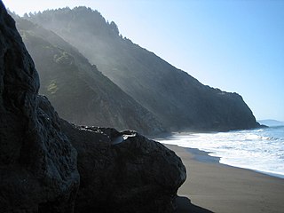
The Lost Coast is a mostly natural and undeveloped area of the California North Coast in Humboldt and Mendocino Counties, which includes the King Range. It was named the "Lost Coast" after the area experienced depopulation in the 1930s. In addition, the steepness and related geotechnical challenges of the coastal mountains made this stretch of coastline too costly for state highway or county road builders to establish routes through the area, leaving it the most undeveloped and remote portion of the California coast. Without any major highways, communities in the Lost Coast region such as Petrolia, Shelter Cove, and Whitethorn are isolated from the rest of California.
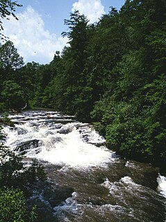
Pine Creek is a tributary of Mahantango Creek in Schuylkill and Dauphin counties, Pennsylvania, in the United States. It is approximately 23.7 miles (38.1 km) long. The creek flows through Foster Township, Hegins Township, Hubley Township, and Upper Mahantango Township in Schuylkill County and Lykens Township in Dauphin County. The creek's watershed has an area of 76.8 square miles (199 km2) and its tributaries include Rausch Creek and Deep Creek. Pine Creek is considered by the Pennsylvania Department of Environmental Protection to be impaired by abandoned mine drainage and resource extraction. However, it is designated as a coldwater fishery.

U.S. Route 50 in West Virginia runs from the border with Ohio to Virginia, passing briefly through Garrett County, Maryland, and following the Northwestern Turnpike. Prior to the U.S. Highway System it was West Virginia Route 1 and in the 1930s, the road was not finished in Maryland. Today the section of US 50 from Clarksburg to Parkersburg on the Ohio River is part of Corridor D of the Appalachian Development Highway System.

Virginia State Route 311 and West Virginia Route 311 are adjoining state highways in the U.S. states of Virginia and West Virginia. The two state highways together run 58.7 miles (94.5 km) from U.S. Route 11 in Salem, Virginia north to Interstate 64 and U.S. Route 60 near White Sulphur Springs, West Virginia. The two Virginia portions of Route 311 are maintained by the Virginia Department of Transportation, with the exception of the city-maintained portion within Salem. The West Virginia segments are maintained by the West Virginia Division of Highways.
The Soque River and its watershed are located entirely within the county boundaries of Habersham County in northeast Georgia. The Soque is a tributary of the Chattahoochee River. Portions of the river run along State Route 197.

State Route 80 is a primary state highway in the southwest part of the U.S. state of Virginia. It runs from the Kentucky state line at Breaks Interstate Park east to U.S. Route 11 near Meadowview. Kentucky Route 80 and Missouri's Route 80 continue the number west to Matthews, Missouri.

State Route 42 is a primary state highway in the U.S. state of Virginia. Running parallel to and west of Interstate 81, SR 42 consists of three sections with gaps filled by secondary routes in between. Some of SR 42 lies along the old Fincastle Turnpike. Another major piece, from near Clifton Forge to Buffalo Gap, parallels the old Virginia Central Railroad.
Tolay Creek is a 12.5-mile-long (20.1 km) southward-flowing stream in southern Sonoma County, California, United States, which flows through Tolay Lake and ends in north San Pablo Bay.

The Pine Creek Rail Trail is a rail trail in the Appalachian Mountains of north-central Pennsylvania.

Sprout Creek is a 24.8-mile-long (39.9 km) creek located entirely within Dutchess County, New York, United States. It is the largest tributary of Fishkill Creek, entering that creek some 11 miles (18 km) upstream from the Hudson River. The creek is annually stocked with 6,000 brown trout, and maintains its own natural population of trout.

The Pennsylvania State Game Lands Number 25 are Pennsylvania State Game Lands in Elk County in Pennsylvania in the United States providing hunting, bird watching, and other activities.