
State Route 156, also known as Lee Canyon Road, is a state highway in Clark County, Nevada. The road is one of two highways connecting U.S. Route 95 to the Humboldt-Toiyabe National Forest and Spring Mountains area northwest of Las Vegas, and its entire length is designated a Nevada Scenic Byway.

State Route 161 is a state highway in Clark County, Nevada. It is known as Goodsprings Road, connecting the town of Goodsprings to Interstate 15 at Jean. The route was part of State Route 53 prior to 1976.
State Route 318 is a state highway in eastern Nevada. It is often used as a shortcut for long-distance traffic along U.S. Route 93, bypassing the longer and less direct route U.S. Route 93 follows between Ely and Crystal Springs. The highway was established in the 1930s as State Route 38 and State Route 38A, and was renumbered to SR 318 in 1976. At a total of 110.762 miles (178.254 km), it is the longest state route in Nevada. The road is used for open speed highway races twice a year.

State Route 208 is a state highway within the counties of Douglas and Lyon in Nevada, United States. It connects U.S. Route 395 north of Topaz Lake to U.S. Route 95 Alternate in Yerington. The road serves as the primary transportation corridor of Smith Valley and is Main street in Yerington. The route was originally a portion of State Route 3.
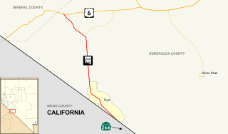
State Route 264 is a 33.67-mile (54.19 km) state highway in Esmeralda County, Nevada, United States. It connects California State Route 266 to U.S. Route 6 via the town of Dyer, Nevada. The majority of the route is known as Fish Lake Valley Road, with the northern portion referred to as the Dicalite Cutoff. A majority of the route was originally designated State Route 3A.

In the U.S. state of Nevada, U.S. Route 95 Alternate is an alternate route of U.S. Route 95 located in the western part of the state. It connects Schurz to Interstate 80 via the cities of Yerington and Fernley.
State Route 340 is a short state highway in Lyon County, Nevada. The route covers a portion of Bridge Street in the city of Yerington.

State Route 360 is a state highway in the southern portion of Mineral County, Nevada, United States. The route connects the former town of Basalt to the rest of Mineral County. A road has been in the place of SR 360 since 1919, and became State Route 10 by 1929.
State Route 374 is a state highway in Nye County, Nevada, United States. It serves as Nevada's gateway to Death Valley National Park, connecting the park to Beatty. The highway was known as State Route 58 prior to 1976.
State Route 400 is a state highway in central Pershing County, Nevada. It connects the rural town of Unionville to Mill City. The route originally extended further south under its prior designation as State Route 50.
State Route 756 is a state highway in Douglas County, Nevada. It connects Centerville to the town of Gardnerville. The route previously existed as State Route 56.
State Route 487 is a north–south state highway in White Pine County, Nevada. The route follows Baker Road from the Utah–Nevada state line southeast of Baker to U.S. Route 6 and U.S. Route 50. The route was previously known as State Route 73 prior to 1976. SR 487 is designated as a Nevada Scenic Byway.
State Route 488 is an east–west state highway in White Pine County, Nevada. The route covers Lehman Caves Road connecting the town of Baker to Great Basin National Park. The route existed as State Route 74 prior to 1976. SR 488 has been designated a Nevada Scenic Byway.
State Route 2B was one of Nevada’s original state highways, first appearing on official state highway maps around 1929. The western terminus was at its junction with SR 2A about 6 miles (9.7 km) east of Dayton. It ran east along present-day Fort Churchill Road and then turned south along present-day Alternate US 95 to Yerington.
State Route 3 was the original designation for SR 208, SR 266 and SR 429. It was also the original designation for sections of US 6, US 50, US 95, Alternate US 95, US 395, and SR 430.
State Route 3C was the former route number for Walker Road, an unimproved road that ran from the California state line southwest of Hawthorne to SR 208 south of Yerington.

State Route 824 is a state highway in Lyon County, Nevada, United States. It runs from State Route 208 near Smith north and west to State Route 823.
State Route 379 covers Duckwater Road, a 19.532-mile (31.434 km) state highway in Nye County, Nevada, United States. The route serves the Duckwater Indian Reservation, connecting the community of Duckwater to U.S. Route 6 at Currant. The highway was formerly a part of State Route 20 prior to the 1970s.

U.S. Route 95 is a major U.S. highway traversing the U.S. state of Nevada from north to south directly through Las Vegas and providing connections to both Carson City and Reno. US 95 is cosigned with Interstate 80 for 95 miles (153 km) between a junction in Churchill County and Winnemucca before heading north into Oregon at McDermitt.
State Route 378 was a 2.7-mile (4.3 km) state highway in Nye County, Nevada, United States. It connected the community of Round Mountain to State Route 376. The highway originated as State Route 70 in 1941 and was later renumbered to State Route 92 before becoming SR 378 in 1976. The route was removed from the state highway system by 1999 to make way for an expansion of the adjacent Round Mountain Gold Mine.


