Route 34 is a state highway in the central part of the U.S. state of New Jersey. The route runs 26.79 mi (43.11 km) from an intersection with Route 35 and Route 70 in Wall Township, Monmouth County north to an intersection with U.S. Route 9 in Old Bridge Township, Middlesex County. The route is a four-lane divided highway between its southern terminus and the north end of the Route 33 concurrency in Howell Township; along this stretch, the route intersects the Garden State Parkway and Interstate 195 (I-195)/Route 138 within a short distance of each other. North of Route 33, Route 34 is an undivided two- to four-lane road that intersects Route 18 in Colts Neck Township and Route 79 in Matawan. Route 34 passes through mostly suburban areas along its route.

Route 7 is a state highway in the northern part of New Jersey in the United States. It has two sections, an east–west alignment running from U.S. Route 1/9 Truck in Jersey City to Route 21 in Belleville, and a north–south alignment running from the Newark/Belleville to the Nutley/Clifton border. The New Jersey Department of Transportation (NJDOT) lists Route 7 as a single north–south highway with a small gap between the alignments. The entire highway has a combined length of 9.46 mi (15.22 km).

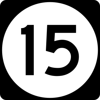
Route 15 is a state highway in New Jersey, spanning Morris and Sussex counties, which travels for 19 miles (31 km) from U.S. Route 46 in Dover to an intersection with U.S. Route 206 in Frankford Township. It becomes a divided highway in Wharton Borough until becoming a freeway bypass near Sparta. Route 15 was originally Route 6A from 1927 until 1953, when a renumbering occurred and the route was given its current number. Since the finishing of the Sparta Bypass, the New Jersey Department of Transportation (NJDOT) and North Jersey Transportation Planning Authority have considered more bypasses and alignment changes for Route 15.

Route 17 is a state highway in Bergen County, New Jersey, United States, that provides a major route from the George Washington Bridge, Lincoln Tunnel and other northeast New Jersey points to the New York State Thruway at Suffern, New York. It runs 27.20 mi (43.77 km) from an intersection with Route 7 and County Route 507 (CR 507) in North Arlington north to the New York border along Interstate 287 (I-287) in Mahwah, where New York State Route 17 (NY 17) continues into New York. Between Route 7 and Route 3 in Rutherford, Route 17 serves as a local road. From Route 3 north to the junction with U.S. Route 46 (US 46) in Hasbrouck Heights, the road is a suburban arterial with jughandles. The portion of Route 17 from US 46 to I-287 near the state line in Mahwah is a limited-access road with all cross traffic handled by interchanges, and many driveways and side streets accessed from right-in/right-out ramps from the right lane. For three miles (5 km) north of Route 4, well over a hundred retail stores and several large shopping malls line the route in the borough of Paramus. The remainder of this portion of Route 17 features lighter suburban development. The northernmost portion of Route 17 in Mahwah runs concurrently with I-287 to the New York border.

Route 44 is a state highway located in Gloucester County in the U.S. state of New Jersey. It runs 10.28 mi (16.54 km) from Barker Avenue in Bridgeport to a cul-de-sac at a ramp from southbound Interstate 295 (I-295) and U.S. Route 130 in Thorofare. The route, which is mostly a two-lane undivided road, passes through the communities of Gibbstown and Paulsboro in the northern part of the county, a short distance south of the Delaware River. Route 44 generally runs a short distance to the north of I-295/US 130 for much of its length.

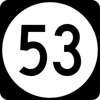
Route 53 is a state highway in Morris County in the U.S. state of New Jersey. It runs 4.66 mi (7.50 km) from U.S. Route 202 in Morris Plains north to Bloomfield Avenue in Denville Township. The route, which is a two-lane undivided highway most of its length, intersects with Route 10, Interstate 80, and U.S. Route 46. For most of its length, the route runs a short distance to the east of New Jersey Transit's Morristown Line. It passes through industrial areas and wooded residential neighborhoods along its route.

Route 77 is a state highway in the southern part of the U.S. state of New Jersey. It runs 22.55 mi (36.29 km) from an intersection with Route 49 in Bridgeton in Cumberland County north to a junction with Route 45 in Mullica Hill in Gloucester County. It is a mostly two-lane, undivided road traversing through farmland in Cumberland, Salem, and Gloucester Counties. Along the way, Route 77 intersects Route 56 in Upper Deerfield Township and U.S. Route 40 in Upper Pittsgrove Township.

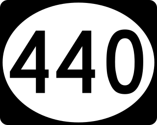
Route 440 is a state highway in New Jersey, United States. It comprises two segments, a 5.15-mile (8.29 km) freeway in Middlesex County linking Interstate 287 (I-287) and the New Jersey Turnpike (I-95), in Edison to the Outerbridge Crossing in Perth Amboy and a 8.18-mile (13.16 km) four-lane divided highway in Hudson County running from the Bayonne Bridge in Bayonne to U.S. Route 1/9 Truck in Jersey City. These two segments are connected by New York State Route 440 (NY 440), which runs across Staten Island. The freeway portion in Middlesex County is six lanes wide and interchanges with the Garden State Parkway and US 9 in Woodbridge.

Interstate 78 (I-78) is an east–west route stretching from Union Township, Lebanon County, Pennsylvania, to New York City. In New Jersey, I-78 is called the Phillipsburg–Newark Expressway and the Newark Bay–Hudson County Extension of the New Jersey Turnpike. The highway runs for 67.83 miles (109.16 km) in the northern part of the state of New Jersey from the I-78 Toll Bridge over the Delaware River at the Pennsylvania state line in Phillipsburg, Warren County, east to the Holland Tunnel under the Hudson River at the New York state line in Jersey City, Hudson County. The Phillipsburg–Newark Expressway portion of I-78, formally called the Lightning Division Memorial Highway, runs from the Phillipsburg area east across rural areas of western New Jersey before entering suburban areas in Somerset County. The road crosses the Watchung Mountains, widening into a local–express lane configuration at Route 24 as it continues through urban areas to Newark. Here, I-78 intersects the mainline of the New Jersey Turnpike (I-95) and becomes the Newark Bay Extension, crossing the Newark Bay Bridge and continuing to Jersey City. The route, along with Route 139, follows a one-way pair of surface streets to the Holland Tunnel.

U.S. Route 9 is a U.S. highway in the northeast United States, running from Laurel, Delaware north to Champlain, New York. In New Jersey, it runs from Cape May to Fort Lee northwards.

U.S. Route 30 is a U.S. highway running from Astoria, Oregon east to Atlantic City, New Jersey. In the U.S. state of New Jersey, US 30 runs 58.26 miles (93.76 km) from the Benjamin Franklin Bridge at the Delaware River in Camden, Camden County while concurrent with Interstate 676 (I-676) southeast to Virginia Avenue in Atlantic City, Atlantic County. Most of the route in New Jersey is known as the White Horse Pike and is four lanes wide. The road runs through mostly developed areas in Camden County, with surroundings becoming more rural as the road approaches Atlantic County. US 30 runs through several towns including Collingswood, Berlin, Hammonton, Egg Harbor City, and Absecon.
Pre-1927 Route 4 was a route in New Jersey that ran from Absecon north to Rahway, existing from 1916 to 1927. Today, it is part of the following routes:
Pre-1927 Route 18 was a route in New Jersey that ran from Camden east to Toms River, existing from 1923 to 1927. Today, it is part of the following routes:
Pre-1927 Route 14 was a route in New Jersey that ran from Cape May north to Egg Harbor City, existing from 1917 to 1927. Today, it is part of the following routes:
Pre-1927 Route 6 was a route in New Jersey that ran from Camden south to Mullica Hill, where it headed southwest to Salem, southeast to Bridgeton, and north back to Mullica Hill. The route existed from 1922 to 1927. Today, it is part of the following routes:
Pre-1927 Route 7 was a route in New Jersey that ran from Hightstown east to Asbury Park, existing from 1916 to 1927. Today, it is part of the following routes:
Pre-1927 Route 8 was a route in New Jersey that ran from Montclair north to the New York border near Unionville, New York, existing between 1916 and 1927. Today, it is part of the following routes:
Pre-1927 Route 8 Spur was a route in New Jersey that ran from Dingman's Ferry east to Franklin Furnace, existing from 1926 to 1927. Today, it is part of the following routes:
Pre-1927 Route 15 was a route in New Jersey that ran from Bridgeton east to Rio Grande, existing between 1917 and 1927. Today, it is part of the following routes:
Pre-1927 Route 16 was a route in New Jersey that ran from Princeton north to Morristown, existing from 1921 to 1927. Today, it is part of the following routes:
This page is based on this
Wikipedia article Text is available under the
CC BY-SA 4.0 license; additional terms may apply.
Images, videos and audio are available under their respective licenses.


