
The Nez Percé are an Indigenous people of the Plateau who are presumed to have lived on the Columbia River Plateau in the Pacific Northwest region for at least 11,500 years.

Hin-mah-too-yah-lat-kekt, popularly known as Chief Joseph, Young Joseph, or Joseph the Younger, was a leader of the Wal-lam-wat-kain (Wallowa) band of Nez Perce, a Native American tribe of the interior Pacific Northwest region of the United States, in the latter half of the 19th century. He succeeded his father Tuekakas in the early 1870s.

Henrys Lake is a small, shallow alpine lake in the western United States, in eastern Idaho. Approximately 8 square miles (21 km2) in area, at 4 miles (6.4 km) in length and 2 miles (3.2 km) in width, its surface elevation is 6,472 ft (1,973 m) above sea level.

The Nez Perce War was an armed conflict in 1877 in the Western United States that pitted several bands of the Nez Perce tribe of Native Americans and their allies, a small band of the Palouse tribe led by Red Echo (Hahtalekin) and Bald Head, against the United States Army. Fought between June and October, the conflict stemmed from the refusal of several bands of the Nez Perce, dubbed "non-treaty Indians," to give up their ancestral lands in the Pacific Northwest and move to an Indian reservation in Idaho Territory. This forced removal was in violation of the 1855 Treaty of Walla Walla, which granted the tribe 7.5 million acres of their ancestral lands and the right to hunt and fish on lands ceded to the U.S. government.
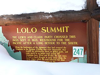
Lolo Pass, elevation 5,233 feet (1,595 m), is a mountain pass in the western United States, in the Bitterroot Range of the northern Rocky Mountains. It is on the border between the states of Montana and Idaho, approximately forty miles (65 km) west-southwest of Missoula, Montana.

The Nez Perce National Historical Park is a United States National Historical Park comprising 38 sites located across the states of Idaho, Montana, Oregon, and Washington, which include traditional aboriginal lands of the Nez Perce people. The sites are strongly associated with the resistance of Chief Joseph and his band, who in June 1877 migrated from Oregon in an attempt to reach freedom in Canada and avoid being forced on to a reservation. They were pursued by U.S. Army cavalry forces and fought numerous skirmishes against them during the so-called Nez Perce War, which eventually ended with Chief Joseph's surrender in the Montana Territory.

The Battle of the Big Hole was fought in Montana Territory, August 9–10, 1877, between the United States Army and the Nez Perce tribe of Native Americans during the Nez Perce War. Both sides suffered heavy casualties. The Nez Perce withdrew in good order from the battlefield and continued their long fighting retreat that would result in their attempt to reach Canada and asylum.
The Bitterroot Valley is located in southwestern Montana, along the Bitterroot River between the Bitterroot Range and Sapphire Mountains, in the Northwestern United States.
Big Hole National Battlefield preserves a battlefield in the western United States, located in Beaverhead County, Montana. In 1877, the Nez Perce fought a delaying action against the U.S. Army's 7th Infantry Regiment here on August 9 and 10, during their failed attempt to escape to Canada. This action, the Battle of the Big Hole, was the largest battle fought between the Nez Perce and U.S. Government forces in the five-month conflict known as the Nez Perce War.

Bitterroot National Forest comprises 1.587 million acres (6,423 km²) in west-central Montana and eastern Idaho, of the United States. It is located primarily in Ravalli County, Montana, but also has acreage in Idaho County, Idaho (29.24%), and Missoula County, Montana (0.49%).

The Nez Perce (Nee-Me-Poo) National Historic Trail follows the route taken by a large group of the Nez Perce tribe in 1877 to avoid being forced onto a reservation. The 1,170-mile (1,883 km) trail was created in 1986 as part of the National Trails System Act and is managed by the U.S. Forest Service. The trail traverses through portions of the U.S. states of Oregon, Idaho, Wyoming, and Montana and connects sites across these states that commemorate significant events of the Nez Perce War that took place between June and October 1877, as several bands of the Nez Perce tried to escape capture by the U.S. Cavalry. The sites are among the 38 that are part of the National Park service's Nez Perce National Historical Park, managed over all by the National Park Service, with some sites managed by local and state affiliated organizations.

White Bird, also referred to as White Pelican, was leader, war chief and tooat of the Lamátta or Lamtáama band of the Nez Perce tribe with the Lamata village along the Salmon River. His band and the village took its name from Lahmatta, by which White Bird Canyon was known to the Nez Perce.
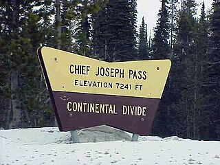
Chief Joseph Pass is a mountain pass on the continental divide of the Rocky Mountains in the northwestern United States joining Lemhi County, Idaho, and Beaverhead County, Montana. The pass is in the Bitterroot Mountains and is traversed by Montana Highway 43; it is named after Chief Joseph of the Wallowa band of the Nez Perce tribe, who traversed the pass in the summer of 1877 during the Nez Perce War, prior to the Battle of the Big Hole to the east.

The Wallowa–Whitman National Forest is a United States National Forest in the U.S. states of Oregon and Idaho. Formed upon the merger of the Wallowa and Whitman national forests in 1954, it is located in the northeastern corner of the state, in Wallowa, Baker, Union, Grant, and Umatilla counties in Oregon, and includes small areas in Nez Perce and Idaho counties in Idaho. The forest is named for the Wallowa band of the Nez Perce people, who originally lived in the area, and Marcus and Narcissa Whitman, Presbyterian missionaries who settled just to the north in 1836. Forest headquarters are located in Baker City, Oregon with ranger districts in La Grande, Joseph and Baker City.

The Old Chief Joseph Gravesite, also known as Nez Perce Traditional Site, Wallowa Lake, Chief Joseph Cemetery and Joseph National Indian Cemetery is a Native American cemetery near Joseph, Oregon. The area was also a traditional campsite of the Nez Perce and may be archaeologically significant. It was declared a National Historic Landmark in 1985, listed as Wallowa Lake Site. It is a component of the Nez Perce National Historical Park.
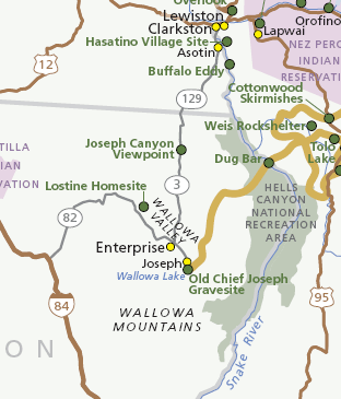
Joseph Canyon is a 2,000-foot (610 m)-deep basalt canyon in northern Wallowa County, Oregon, and southern Asotin County, Washington, United States.

Weippe Prairie is a "beautiful upland prairie field of about nine by twenty miles of open farmland bordered by pine forests" at 3,000 feet elevation in Clearwater County, Idaho, at Weippe, Idaho. Camas flowers grow well there, and attracted native gatherers of the camas roots. It is the location in Idaho where the Lewis and Clark Expedition emerged from crossing the Bitterroot Mountains on the Lolo Trail and first met the Nez Perce tribe of Native Americans.

The Nez Perce native Americans fled through Yellowstone National Park between August 20 and Sept 7, during the Nez Perce War in 1877. As the U.S. army pursued the Nez Perce through the park, a number of hostile and sometimes deadly encounters between park visitors and the Indians occurred. Eventually, the army's pursuit forced the Nez Perce off the Yellowstone plateau and into forces arrayed to capture or destroy them when they emerged from the mountains of Yellowstone onto the valley of Clark's Fork of the Yellowstone River.
The six national parks, reserves, historic sites, and monuments in Idaho contain a wide variety of interesting places and experiences. These include recreational areas, archeological sites, nature preserves and volcanic parks.
The Chief Joseph Trail Ride is an annual horse trail ride that follows the route the Nimiipuu took during the Nez Perce War in 1877. The trail in its entirety is 1,300 miles long, separated into thirteen separate rides, which take place sequentially. The ride is on a 13-year cycle. The trail ride was started in 1965 by the Appaloosa Horse Club.