Nieuwland, Kortland, en 's-Graveland

Last updated

Nieuwland, Kortland, en 's-Graveland (often abbreviated to "Nieuwland c.a.") is a former municipality in the Dutch province of South Holland. It was located on three sides of the city of Schiedam. The municipality existed between 1817 and 1855. [1]

Netherlands Constituent country of the Kingdom of the Netherlands in Europe

The Netherlands is a country located mainly in Northwestern Europe. The European portion of the Netherlands consists of twelve separate provinces that border Germany to the east, Belgium to the south, and the North Sea to the northwest, with maritime borders in the North Sea with Belgium, Germany and the United Kingdom. Together with three island territories in the Caribbean Sea—Bonaire, Sint Eustatius and Saba— it forms a constituent country of the Kingdom of the Netherlands. The official language is Dutch, but a secondary official language in the province of Friesland is West Frisian.

South Holland Province of the Netherlands

South Holland is a province of the Netherlands with a population of just over 3.6 million as of 2015 and a population density of about 1,300/km2 (3,400/sq mi), making it the country's most populous province and one of the world's most densely populated areas. Situated on the North Sea in the west of the Netherlands, South Holland covers an area of 3,403 km2 (1,314 sq mi), of which 585 km2 (226 sq mi) is water. It borders North Holland to the north, Utrecht and Gelderland to the east, and North Brabant and Zeeland to the south. The provincial capital is The Hague, while its largest city is Rotterdam.

Schiedam City and Municipality in South Holland, Netherlands

Schiedam is a city and municipality in the province of South Holland in the Netherlands. It is part of the Rotterdam metropolitan area. The city is located west of Rotterdam, east of Vlaardingen, and south of Delft. In the south it is connected with the village of Pernis by the Beneluxtunnel.

The municipality consisted of three polders: Kortland, west of Schiedam; Nieuwland, north of the city; and 's-Graveland, northeast of the city. Nieuwland is now the name of a neighbourhood of Schiedam, located in the former municipality.

Polder low-lying tract of land enclosed by embankments (barriers) known as dikes

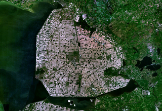
A polder is a low-lying tract of land enclosed by dikes that form an artificial hydrological entity, meaning it has no connection with outside water other than through manually operated devices. There are three types of polder:

  1. Land reclaimed from a body of water, such as a lake or the sea bed
  2. Flood plains separated from the sea or river by a dike
  3. Marshes separated from the surrounding water by a dike and subsequently drained; these are also known as koogs especially in Germany

According to the 19th-century historian A.J. van der Aa, [2] Nieuwland c.a. had about 330 inhabitants.

Related Research Articles

Bommenede former town and former municipality in Zeeland

Bommenede or Bommenee is a former island, village, and municipality in the Netherlands, located about 5 km east of the city of Brouwershaven.

s-Gravesloot former municipality in the Dutch province of Utrecht

's-Gravesloot is a former hamlet and municipality in the Dutch province of Utrecht. It was located between Kamerik and Woerden.

Ackersdijk en Vrouwenregt is a former municipality in the Dutch province of South Holland, located about halfway between Delft and Schiedam. It existed from 1817 to 1855, when it was joined to the municipality of Vrijenban. The area is now part of the municipalities of Midden-Delfland, Delft, and Pijnacker-Nootdorp.

's-Gravenhoek is a former municipality in the Dutch province of Zeeland. It consisted of a number of polders on the north side of the island of Noord-Beveland, east of Wissenkerke.

Kampensnieuwland or Kampernieuwland is a former municipality in the Dutch province of Zeeland. It existed until 1816, when it merged into the municipality of Wissenkerke.

Klaaskinderenkerke former village and former municipality in Zeeland, Netherlands

Klaaskinderenkerke is a former village in the Dutch province of Zeeland. The polder Klaaskinderen was flooded on December 14, 1511, and was never reclaimed again. The church of Klaaskinderenkerke disappeared in this flood, and in the 19th century, only a small hamlet was left.

Rengerskerke en Zuidland is a former municipality in the Dutch province of Zeeland. It existed until 1813, when it was merged with Kerkwerve.

Sint Joosland is a former municipality in the Dutch province of Zeeland. It existed until 1816, when it was merged with Nieuwland to form the new municipality of Nieuw- en Sint Joosland. The municipality consisted of a single polder southeast of the current village of Nieuw- en Sint Joosland.

Koedood is a hamlet in the Dutch province of South Holland. It is located on the border of the municipalities of Albrandswaard and Barendrecht.

Broek was a municipality in the Dutch province of South Holland, located west and north of Gouda. A longer name of the municipality, Broek, Bloemendaal, Broekhuizen, Thuil en het Weegje names the polders that are part of the municipality.

Kethel en Spaland is a former municipality in the Dutch province of South Holland. It was located to the north of the city of Schiedam, and covered the village of Kethel and the hamlet Kandelaar.

Klaaswaal farm village in the Netherlands

Klaaswaal is a village and former municipality in the Dutch province of South Holland. It is centrally located on one of the island Hoeksche Waard. Klaaswaal was a separate municipality until 1984, when it was merged with Numansdorp to form the municipality Cromstrijen.

Nederslingeland is a polder in the Dutch province of South Holland. It is located about 5 km northwest of the city of Gorinchem. The hamlet Pinkeveer is located in the polder.

Nieuweveen is a former municipality in the Dutch province of South Holland. It was located northwest of Nootdorp. It included the Nieuweveenpolder and the Oost Negentig Morgen polder. The municipality contained one hamlet, also called Nieuweveen, located around the Veenweg road; the Roman Catholic Church of Nootdorp was located in Nieuwveen.

Onwaard is a former municipality in the Dutch province of South Holland. It was located east of the village of Melissant on the island Goeree-Overflakkee. The municipality contained no villages nor hamlets; only a few farms. It consisted of a number of small polders: Onwaard, Oud-Kraaijer, Kraaijenisse, and part of the Nieuw-Kraaijer polder.

Oud- en Nieuw-Mathenesse is a former municipality in the Dutch province of South Holland. It was located to the west of Schiedam.

De Vennip is a former municipality in the Dutch province of South Holland. It consisted of a small area of land east of Hillegom, and a large part of the Haarlemmermeer lake, including the island of Beinsdorp.

Baalhoek is a hamlet in the Dutch province of Zeeland. It is located in the municipality of Hulst, about 5 km east of Kloosterzande on the dyke of the Westerschelde.

References

  1. Ad van der Meer and Onno Boonstra, "Repertorium van Nederlandse gemeenten", KNAW, 2006.
  2. Abraham Jacob van der Aa , "Aardrijkskundig woordenboek der Nederlanden", vol. 8 (N/O), 1846..

Coordinates: 51°55′13″N4°23′11″E / 51.92028°N 4.38639°E / 51.92028; 4.38639

Geographic coordinate system Coordinate system

A geographic coordinate system is a coordinate system that enables every location on Earth to be specified by a set of numbers, letters or symbols. The coordinates are often chosen such that one of the numbers represents a vertical position and two or three of the numbers represent a horizontal position; alternatively, a geographic position may be expressed in a combined three-dimensional Cartesian vector. A common choice of coordinates is latitude, longitude and elevation. To specify a location on a plane requires a map projection.