Tikander Lake is an unorganized territory in Saint Louis County, Minnesota, United States. The population was 783 at the 2000 census.

Oak Hill Country Club is a country club located in Pittsford, New York, a suburb southeast of Rochester. Founded in 1901 and best known for its golf course, the club has hosted multiple major championships.

This is a list of the extreme points of North America: the points that are highest and lowest, and farther north, south, east or west than any other location on the continent. Some of these points are debatable, given the varying definitions of North America.
The Chute River is in Cumberland County, Maine, United States and connects Long Lake to Brandy Pond in Naples. It is spanned by U.S. Route 302 at the Naples Bridge, formerly the Naples Swing Bridge until 2012.
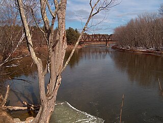
The Saco River is a river in northeastern New Hampshire and southwestern Maine in the United States. It drains a rural area of 1,703 square miles (4,410 km2) of forests and farmlands west and southwest of Portland, emptying into the Atlantic Ocean at Saco Bay, 136 miles (219 km) from its source. It supplies drinking water to roughly 250,000 people in thirty-five towns; and historically provided transportation and water power encouraging development of the cities of Biddeford and Saco and the towns of Fryeburg and Hiram. The name "Saco" comes from the Eastern Abenaki word [sɑkohki], meaning "land where the river comes out". The Jesuit Relations, ethnographic documents from the 17th century, refer to the river as Chouacoet.

Radium Springs is an unincorporated community located on the southeast outskirts of Albany in Dougherty County, Georgia, United States. It is part of the Albany Metropolitan Statistical Area.

The Suncook River is a 35.7-mile-long (57.5 km) river located in central New Hampshire in the United States. It is a tributary of the Merrimack River, which flows to the Gulf of Maine.
The Fresh River is a 3.2-mile (5.1 km) long stream in southeastern New Hampshire in the United States. It is a tributary of the Piscassic River, which flows into the Lamprey River and is part of the Great Bay and Piscataqua River watershed leading to the Atlantic Ocean.
The Rural Municipality of Glenwood is a former rural municipality (RM) in the Canadian province of Manitoba. It was originally incorporated as a rural municipality on December 22, 1883. It ceased on January 1, 2015 as a result of its provincially mandated amalgamation with the Town of Souris to form the Municipality of Souris – Glenwood.

Johnsville, also known as Shauck, is an unincorporated community in northern Perry Township, Morrow County, Ohio, United States. Although it is unincorporated, it has a post office, with the ZIP code of 43349. It is located at the intersection of U.S. Route 42 with State Route 314.
The Eisenhower Golf Club, named after U.S. President Dwight Eisenhower, is the golf course located at Crownsville, Maryland in Anne Arundel County. Just a mile from Maryland capital Annapolis, home of the United States Naval Academy. Golf course was created by golf architect Ed Auit in 1969 on a 220 acres splendidly wooded landscape, takes golfers though forestland, around one of Maryland's finest lakes, and alongside numerous creeks and swales. This course is run by Billy Casper Golf. This course is an 18-hole public golf course, 70/71 par course. At the Ike is 6,659 yards with the slope of 126. The Back is 6,288 yards, slope of 121. The Middle is 5,876 yards, slope of 118. The Front is 4,884 yards, slope of 108.
The Charles River is a 1.2-mile-long (1.9 km) channel connecting Charles Pond with the Old Course Saco River in the town of Fryeburg in western Maine, United States. It forms the natural extension of the Cold River, which flows from the White Mountains, New Hampshire, around Evans Notch south to Charles Pond.
The Little River is a 1.6-mile-long (2.6 km) inlet of the Atlantic Ocean in southern Maine in the United States. It is formed by the juncture of the Merriland River and Branch Brook, and its course serves as the boundary between the towns of Kennebunk and Wells.

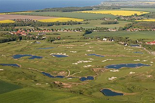
The 42nd Walker Cup Match was played on September 12 and 13, 2009 at the Merion Golf Club in Ardmore, Pennsylvania, United States. Team United States won 16½ to 9½ for its third consecutive win.
Mexican Town is a neighborhood of Ajo, Arizona in Pima County, Arizona, in the United States.

KRBX, branded as Radio Boise, is a listener-supported, independent community radio station headquartered in Boise, Idaho, United States, broadcasting at 89.9 FM and 93.5 FM, presenting a freeform radio format. The station is operated by the non-profit Boise Community Radio Project and was established in 2011. Its main terrestrial transmitter is located in the Owyhee Mountains of eastern Oregon, and its city of license is Caldwell, Idaho, with a translator in downtown Boise. It can be heard worldwide on the internet via streaming formats at radioboise.org.
Babel River is a stream in Bethel Census Area, Alaska, in the United States.
Austin Country Club is a private golf club in the southern United States, located in Austin, Texas. Established 120 years ago in 1899, the club moved to its third and present site in 1984, a challenging layout designed by noted course architect Pete Dye.