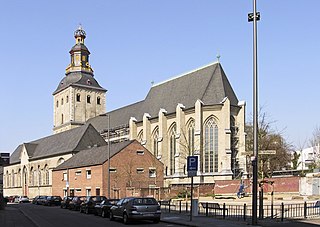
The Basilica church of St. Ursula is located in Cologne, North Rhine-Westphalia, Germany. It is built upon the ancient ruins of a Roman cemetery, where the 11,000 virgins associated with the legend of Saint Ursula are said to have been buried. The church has an impressive reliquary created from the bones of the former occupants of the cemetery. It is one of the twelve Romanesque churches of Cologne and was designated a Minor Basilica on 25 June 1920. While the nave and crossing tower are Romanesque, the choir has been rebuilt in the Gothic style.

Barjas is a village and municipality located in the region of El Bierzo. According to the 2010 census (INE), the municipality has a population of 261 inhabitants.

Stawiska is a village in the administrative district of Gmina Strzegom, within Świdnica County, Lower Silesian Voivodeship, in south-western Poland. Prior to 1945 it was in Germany. It lies approximately 3 kilometres (2 mi) south-west of Strzegom, 13 km (8 mi) north-west of Świdnica, and 55 km (34 mi) south-west of the regional capital Wrocław.

May is a district of Pavlodar Region in northern Kazakhstan. The administrative center of the district is the selo of Koktobe. Population: 11,787 ; 12,601 ; 16,859.
Klocek is a village in the administrative district of Gmina Tuchola, within Tuchola County, Kuyavian-Pomeranian Voivodeship, in north-central Poland. It lies approximately 12 kilometres (7 mi) north-east of Tuchola and 64 km (40 mi) north of Bydgoszcz.
Rakołupy Duże is a village in the administrative district of Gmina Leśniowice, within Chełm County, Lublin Voivodeship, in eastern Poland.
Białystok is a village in the administrative district of Gmina Dołhobyczów, within Hrubieszów County, Lublin Voivodeship, in eastern Poland, close to the border with Ukraine. It lies approximately 13 kilometres (8 mi) south-west of Dołhobyczów, 37 km (23 mi) south of Hrubieszów, and 128 km (80 mi) south-east of the regional capital Lublin.

Zivel is a village in the Kalbajar Rayon of Azerbaijan.
Zielonka is a village in the administrative district of Gmina Gidle, within Radomsko County, Łódź Voivodeship, in central Poland. It lies approximately 5 kilometres (3 mi) north-west of Gidle, 10 km (6 mi) south of Radomsko, and 90 km (56 mi) south of the regional capital Łódź.
Grabki Małe is a village in the administrative district of Gmina Gnojno, within Busko County, Świętokrzyskie Voivodeship, in south-central Poland. It lies approximately 8 kilometres (5 mi) east of Gnojno, 21 km (13 mi) north-east of Busko-Zdrój, and 41 km (25 mi) south-east of the regional capital Kielce.
Wiącka is a village in the administrative district of Gmina Bodzentyn, within Kielce County, Świętokrzyskie Voivodeship, in south-central Poland. It lies approximately 9 kilometres (6 mi) north-west of Bodzentyn and 20 km (12 mi) north-east of the regional capital Kielce.
Kozia Wieś is a village in the administrative district of Gmina Krasocin, within Włoszczowa County, Świętokrzyskie Voivodeship, in south-central Poland. It lies approximately 9 kilometres (6 mi) north-west of Krasocin, 11 km (7 mi) north-east of Włoszczowa, and 42 km (26 mi) west of the regional capital Kielce.
Borek is a village in the administrative district of Gmina Rudniki, within Olesno County, Opole Voivodeship, in south-western Poland.

The Protestant cemetery Bergisch Gladbach road in Mülheim district of Cologne existed since the beginning of the 17th century and is one of the oldest preserved cemeteries in Cologne, Germany. The cemetery is still in operation and used for burials.
Geusenfriedhof is a cemetery in Cologne, Germany. It is the oldest Protestant cemetery in the Rhineland, established around 1584.

Jüdischer Friedhof Deutz is a cemetery in Cologne, Germany. Founded in 1695, it is the oldest Jewish cemetery in the district of Cologne. last burial took place during the Second World War in 1941.
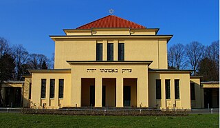
Jüdischer Friedhof Köln-Bocklemünd is a cemetery in Cologne, Germany. A Jewish burial site since 1918, many of its tombstones are noted for their extravagant artistic designs.

Südfriedhof is the German name for the South Cemetery in Cologne, Germany. With an area of over 61 hectares, it is the largest cemetery in Cologne.

Friedhof Trenkebergstraße is a cemetery in Cologne, Germany. The cemetery is 4,600 m² and offers space for 790 graves. Furthermore, there are 16 graves in this cemetery for German victims of the Second World War.

Westfriedhof is a cemetery in Cologne, Germany. With an area of 52 hectares, it is amongst the largest of the cemeteries in the city.


