
Virginia Beach is an independent city located on the southeastern coast of the Commonwealth of Virginia in the United States. As of the 2010 census, the population was 437,994. In 2015, the population was estimated to be 452,745. In 2017 the estimated population was 450,435. Although mostly suburban in character, it is the most populous city in Virginia and the 41st most populous city in the nation. Located on the Atlantic Ocean at the mouth of the Chesapeake Bay, Virginia Beach is included in the Hampton Roads metropolitan area. This area, known as "America's First Region", also includes the independent cities of Chesapeake, Hampton, Newport News, Norfolk, Portsmouth, and Suffolk, as well as other smaller cities, counties, and towns of Hampton Roads.

Newport News is an independent city in the U.S. state of Virginia. As of the 2010 census, the population was 180,719. In 2013, the population was estimated to be 183,412, making it the fifth-most populous city in Virginia.

Hampton is an independent city in the Commonwealth of Virginia in the United States. As of the 2010 census, the population was 137,436.

Cape Charles is a town / municipal corporation in Northampton County, Virginia, United States. The population was 1,009 as of the 2010 U.S.Decennial Census.
Hampton Roads is the name of both a body of water that serves as a wide channel for the James, Nansemond and Elizabeth rivers between Old Point Comfort and Sewell's Point where the Chesapeake Bay flows into the Atlantic Ocean and the surrounding metropolitan region located in the Southeastern Virginia and Northeastern North Carolina portions of the Tidewater region.

The Middle Peninsula is the second of three large peninsulas on the western shore of Chesapeake Bay in Virginia, in the United States. It lies between the Northern Neck and the Virginia Peninsula. This peninsula is bounded by the Rappahannock River on the north and the York River on the south, with the Chesapeake Bay to the east. It encompasses six Virginia counties: Essex, Gloucester, King and Queen, King William, Mathews, and Middlesex. Developed for tobacco plantations in the colonial era, in the 21st century the Middle Peninsula is known for its quiet rural life, vegetable truck-farming, and fishing industry.

The Chesapeake Bay Bridge–Tunnel (CBBT) is a 23-mile (37 km) bridge–tunnel crossing at the mouth of the Chesapeake Bay, the Hampton Roads harbor, and nearby mouths of the James and Elizabeth Rivers in the American state of Virginia. It connects Northampton County on the Delmarva Peninsula and Eastern Shore with Virginia Beach, Norfolk, Chesapeake, and Portsmouth on the Western Shore and South side / Tidewater which are part of the Hampton Roads metropolitan area of eight close cities around the harbor's shores and peninsula. The Bridge-Tunnel originally combined 12 miles (19 km) of trestle, two 1-mile-long (1.6 km) tunnels, four artificial islands, four high-level bridges, approximately 2 miles (3.2 km) of causeway, and 5.5 miles (8.9 km) of northeast and southwest approach roads—crossing the Chesapeake Bay and preserving traffic on the Thimble Shoals and Chesapeake dredged shipping channels leading to the Atlantic. It replaced vehicle ferry services that operated from South Hampton Roads and from the Virginia Peninsula since the 1930s. Financed by toll revenue bonds, the Bridge–Tunnel was opened on April 15, 1964, and remains one of only ten bridge–tunnel systems in the world, three of which are located in the water dominated Hampton Roads area of Tidewater Virginia.

South Hampton Roads is a region located in the extreme southeastern portion of Virginia's Tidewater region in the United States with a total population of 1,191,937. It is part of the Virginia Beach-Norfolk-Newport News, VA-NC MSA, which itself has a population of 1,724,876.

Willoughby Spit is a peninsula of land in the independent city of Norfolk, Virginia in the United States. It is bordered by water on three sides: the Chesapeake Bay to the north, Hampton Roads to the west, and Willoughby Bay to the south.
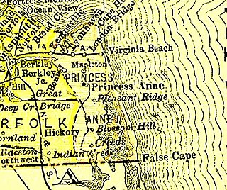
County of Princess Anne is a former county in the British Colony of Virginia and the Commonwealth of Virginia in the United States, first incorporated in 1691. The county was merged into the city of Virginia Beach on January 1, 1963, ceasing to exist.

Hampton Roads Transit (HRT), incorporated on October 1, 1999, began through the voluntary merger of PENTRAN on the Virginia Peninsula and TRT in South Hampton Roads and currently serves over 22 million annual passengers within its 369-square-mile (960 km2) service area around Hampton Roads. The purpose of the HRT is to provide reliable and efficient transportation service and facilities to the Hampton Roads community.

Assateague Island National Seashore is a unit of the National Park Service system of the U.S. Department of the Interior. Located on the East Coast along the Atlantic Ocean in Maryland and Virginia, Assateague Island is the largest natural barrier island ecosystem in the Middle Atlantic states region that remains predominantly unaffected by human development. Located within a three-hour drive to the east and south of the Richmond, Washington, Baltimore, Wilmington, Philadelphia major metropolitan areas plus north of the several clustered smaller cities around Hampton Roads harbor of Virginia with Newport News, Hampton, Norfolk, Portsmouth, Chesapeake and Virginia Beach. The National Seashore offers a setting in which to experience a dynamic barrier island and to pursue a multitude of recreational opportunities. The stated mission of the park is to preserve and protect “unique coastal resources and the natural ecosystem conditions and processes upon which they depend, provide high-quality resource-based recreational opportunities compatible with resource protection and educate the public as to the values and significance of the area”.

Transportation in the Commonwealth of Virginia is by land, sea and air. Virginia's extensive network of highways and railroads were developed and built over a period almost 400 years, beginning almost immediately after the founding of Jamestown in 1607, and often incorporating old established trails of the Native Americans.
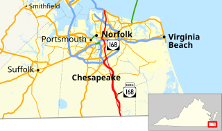
State Route 168 is a primary state highway in the South Hampton Roads region of the U.S. state of Virginia. It runs from the border with North Carolina through the independent cities of Chesapeake and Norfolk where it ends in the Ocean View area near the Hampton Roads Bridge-Tunnel.
Since Norfolk serves as the commercial and cultural center for the geographical region of Hampton Roads, it can be difficult to separate the economic characteristics of Norfolk, from that of the region as a whole. The waterways which almost completely surround the Hampton Roads region also play an important part in the local economy. As a strategic location at the mouth of the Chesapeake Bay, its protected deep water channels serve as major arteries for the import and export of goods from across the Mid-Atlantic, Mid-West, and international destinations, as well as being the location of the world's largest naval base.
Located in the southeastern corner of the state, Norfolk is economically and culturally important to Virginia. A variety of transportation modes have developed around the city's importance and somewhat unusual geography.
Virginia Beach, Virginia's development is tied to the establishment of a transportation infrastructure that allowed access to the Atlantic shoreline.
Historically, the harbor was the key to the Hampton Roads area's growth, both on land and in water-related activities and events. Ironically, the harbor and its tributary waterways were both important transportation conduits and obstacles to other land-based commerce and travel. For hundreds of years, state and community leaders have worked to develop solutions to accommodate both.


