
Union County is a county located in the U.S. state of Tennessee. As of the 2020 census, its population was 19,802. Its county seat is Maynardville. Union County is included in the Knoxville metropolitan statistical area.

Pickett County is a county located in the U.S. state of Tennessee. As of the 2020 census, the population was 5,001, making it the least populous county in Tennessee. Its county seat is Byrdstown. The city of Byrdstown and the Kentucky town of Albany, 11 miles (18 km) to the northeast, are positioned between two Army Corps of Engineers lakes: Dale Hollow Lake, mainly in Tennessee, and Lake Cumberland, in Kentucky. The area is known as "Twin Lakes" and Byrdstown is noted as "The Gateway To Dale Hollow Lake". Every year thousands of people vacation at the many resorts situated along the lakes.
Morgan County is a county located in the U.S. state of Tennessee. As of the 2020 census, the population was 21,035. Its county seat is Wartburg. Morgan County is part of the Knoxville, TN Combined Statistical Area.
Cocke County is a county on the eastern border of the U.S. state of Tennessee. As of the 2020 census, the population was 35,999. Its county seat is Newport. Cocke County comprises the Newport, TN Micropolitan Statistical Area, which is part of the Knoxville-Morristown-Sevierville, Tennessee Combined Statistical Area.

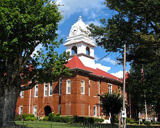
Claiborne County is a county located in the U.S. state of Tennessee. As of the 2020 census, the population was 32,043. Its county seat is Tazewell and its largest city is Harrogate.

Anderson County is a county in the U.S. state of Tennessee. It is located in the northern part of the state in East Tennessee. As of the 2020 census, its population was 77,123. Its county seat is Clinton. Anderson County is included in the Knoxville, TN Metropolitan Statistical Area.

Tazewell is a town in and the county seat of Claiborne County, Tennessee, United States. The population was 2,165 at the 2000 census, 2,218 at the 2010 census, and 2,348 at the 2020 census. The town is named for Tazewell, Virginia, which itself was named for Henry Tazewell (1753–1799), a U.S. senator from Virginia.

The Holston River is a 136-mile (219 km) river that flows from Kingsport, Tennessee, to Knoxville, Tennessee. Along with its three major forks, it comprises a major river system that drains much of northeastern Tennessee, southwestern Virginia, and northwestern North Carolina. The Holston's confluence with the French Broad River at Knoxville marks the beginning of the Tennessee River.
The Powell River is a 195-mile-long river in the United States that rises in Southwest Virginia and flows southwest into East Tennessee.

The Sheltowee Trace Trail is a 343-mile (552.00 km) National Recreation Trail that was created in 1979 and stretches from the Burnt Mill Bridge Trail Head in the Big South Fork National River and Recreation Area in Tennessee to northern Rowan County, Kentucky. The trail is named after Daniel Boone, who was given the name Sheltowee when he was adopted as the son of the great warrior Chief Blackfish of the Shawnee tribe.

U.S. Route 23 (US 23) is a part of the United States Numbered Highway System that runs from Jacksonville, Florida, to Mackinaw City, Michigan. In Virginia, the U.S. Highway runs 60.80 miles (97.85 km) from the Tennessee state line near Weber City north to the Kentucky state line near Pound. US 23, which is known as Orby Cantrell Highway for most of its course, is a four-lane divided highway that follows Corridor B of the Appalachian Development Highway System through Southwest Virginia. The U.S. Highway serves as the main east–west highway of Scott County and the primary north–south highway of Wise County. US 23 runs concurrently with US 58 from Weber City to Duffield and with US 58 Alternate between Big Stone Gap and the independent city of Norton.
Powell Mountain is a mountain ridge of the Ridge-and-valley Appalachians of the Appalachian Mountains. It is a long and narrow ridge, running northeast to southwest, from about Norton, Virginia, to near Tazewell, Tennessee. It separates the Clinch River basin and the Powell River basin of Powell Valley. It was named for an 18th-century explorer.

State Route 80 is a primary state highway in the southwest part of the U.S. state of Virginia. It runs from the Kentucky state line at Breaks Interstate Park east to U.S. Route 11 near Meadowview. Kentucky Route 80 and Missouri's Route 80 continue the number west to Matthews, Missouri. The entire length of SR 80 is part of U.S. Bicycle Route 76.
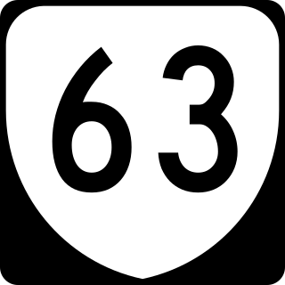
State Route 63 is a primary state highway in the U.S. state of Virginia. The state highway runs 39.28 miles (63.22 km) from U.S. Route 58 Alternate in St. Paul north to SR 80 and SR 83 in Haysi.

State Route 61 is a primary state highway in the U.S. state of Virginia. The state highway runs 48.16 miles (77.51 km) from SR 16 in Tazewell east to U.S. Route 460 in Narrows. SR 61 passes through several narrow creek valleys as it parallels the West Virginia state line through Tazewell, Bland, and Giles counties. The only sizeable community between the highway's endpoints is Rocky Gap, where the highway meets US 52 and Interstate 77 (I-77).
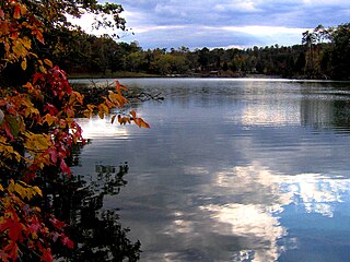
Big Ridge State Park is a state park in Union County, Tennessee, in the southeastern United States. The park consists of 3,687 acres (14.92 km2) on the southern shore of the Norris Reservoir, an impoundment of the Clinch River created by the completion of Norris Dam in 1936. Much of the park's recreational focus is on Big Ridge Lake, a 45-acre (0.18 km2) sub-impoundment of Norris near the center of the park.
Morrison City is an unincorporated community in Sullivan County, Tennessee, United States. Named for pioneer settler Peter Morison, Morrison City developed with the industrial growth of nearby Kingsport, Tennessee, in the 1930s. Peter Morison, his wife Mary Kirkpatrick Morison, and other relatives, are buried in the Morrison Chapel Cemetery, in the heart of the community. They were awarded a land grant by the state of North Carolina, which controlled the area prior to Tennessee Statehood, in 1780. This was to recognize distinguished service during the Battle of King's Mountain.
The Clear Fork is a 42.8-mile-long (68.9 km) tributary of the Cumberland River in Kentucky and Tennessee. By the Cumberland and Ohio rivers, it is part of the Mississippi River watershed.

Arthur is an unincorporated community in Claiborne County, Tennessee, United States. It is located along State Route 63 southwest of Harrogate, and a few miles south of the Cumberland Gap. Its zip code is 37707.

The Poor Fork is a 45-mile (72 km) tributary of the Cumberland River in Letcher and Harlan Counties, southeast Kentucky, in the United States. The river flows from its source at Flat Gap in Letcher County, on the Kentucky–Virginia border, generally southwest to where it meets Martin's Fork in Baxter to form the Cumberland River.
