
Worcester County is a county in the U.S. state of Massachusetts. At the 2020 census, the population was 862,111, making it the second-most populous county in Massachusetts. It is also the largest county in Massachusetts by geographic area. The largest city and traditional shire town is Worcester. Worcester County is part of the Worcester, MA–CT metropolitan statistical area and the Boston-Worcester-Providence combined statistical area.

Leominster is a city in Worcester County, Massachusetts, United States. It is the second-largest city in Worcester County, with a population of 43,222 at the 2023 census. Leominster is located north of Worcester and northwest of Boston. Both Route 2 and Route 12 pass through Leominster. Interstate 190, Route 13, and Route 117 all have starting/ending points in Leominster. Leominster is bounded by Fitchburg and Lunenburg to the north, Lancaster to the east, Sterling and Princeton to the south, and Westminster to the west.

Ayer is a census-designated place (CDP) and the primary settlement in the town of Ayer in Middlesex County, Massachusetts, United States. The population of the CDP was 2,986 at the 2020 census, out of 8,479 in the entire town.

Lunenburg is a town in Worcester County, Massachusetts, United States. The population was 11,782 at the 2020 census.

Route 2 is a 142.29-mile-long (228.99 km) major east–west state highway in Massachusetts, United States. Along with Route 9 and U.S. Route 20 to the south, these highways are the main alternatives to the Massachusetts Turnpike/I-90 toll highway. Route 2 runs the entire length of the northern tier of Massachusetts, beginning at the New York border, where it connects with New York State Route 2, and ending near Boston Common in Boston. Older alignments of Route 2 are known as Route 2A.
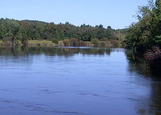
The Nashua River, 37.5 miles (60.4 km) long, is a tributary of the Merrimack River in Massachusetts and New Hampshire in the United States. It is formed in eastern Worcester County, Massachusetts, at the confluence of the North Nashua River and South Nashua River, and flows generally north-northeast past Groton to join the Merrimack at Nashua, New Hampshire. The Nashua River watershed occupies a major portion of north-central Massachusetts and a much smaller portion of southern New Hampshire.

Interstate 190 (I-190) is a 19.26 miles (31.00 km) auxiliary Interstate Highway in the US state of Massachusetts, maintained by the Massachusetts Department of Transportation (MassDOT). Spanning approximately 19 miles (31 km) along a south–north axis, it is a spur route of I-90 in Central Massachusetts. However, its southern terminus exists at its split from I-290 in Worcester, which itself splits from the turnpike in Auburn. Its northern terminus lays at an interchange with Route 2 in Leominster.

The Fitchburg Railroad is a former railroad company, which built a railroad line across northern Massachusetts, United States, leading to and through the Hoosac Tunnel. The Fitchburg was leased to the Boston and Maine Railroad in 1900. The main line from Boston to Fitchburg is now operated as the MBTA Fitchburg Line; Pan Am Railways runs freight service on some other portions.
The Central Massachusetts Railroad was a railroad in Massachusetts. The eastern terminus of the line was at North Cambridge Junction where it split off from the Middlesex Central Branch of the Boston and Lowell Railroad in North Cambridge and through which it had access to North Station in Boston. From there, the route ran 98.77 miles west through the modern-day towns of Belmont, Waltham, Weston, Wayland, Sudbury, Hudson, Bolton, Berlin, Clinton, West Boylston, Holden, Rutland, Oakham, Barre, New Braintree, Hardwick, Ware, Palmer, Belchertown, Amherst, and Hadley to its western terminal junction at N. O. Tower in Northampton with the Connecticut River Railroad.

The Fitchburg Line is a branch of the MBTA Commuter Rail system which runs from Boston's North Station to Wachusett station in Fitchburg, Massachusetts. The line is along the tracks of the former Fitchburg Railroad, which was built across northern Massachusetts, United States, in the 1840s. Winter weekend service includes a specially equipped seasonal "ski train" to Wachusett Mountain.

Route 140 is a 107.76-mile-long (173.42 km) north—south state highway which passes through Bristol, Norfolk and Worcester counties in Massachusetts. The highway follows a southeast-northwest trajectory, running from U.S. Route 6 in New Bedford just north of Buzzards Bay northwest to an intersection with Route 12 in Winchendon, a few miles south of the border with New Hampshire.
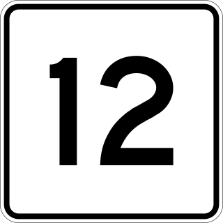
Massachusetts Route 12 is a 64.41-mile-long (103.66 km) north-south state highway that runs through central Massachusetts from a continuation of Connecticut Route 12 at the Connecticut state line at Dudley to the New Hampshire state line at Winchendon where it continues north as New Hampshire Route 12.
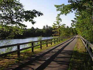
The Nashua River Rail Trail is a 12.5-mile (20.1 km) paved mixed-use rail trail in northern Massachusetts and southern New Hampshire under control of the Massachusetts Department of Conservation and Recreation (DCR). It roughly follows the course of the Nashua River, passing through the towns of Ayer, Groton, Pepperell, and Dunstable, Massachusetts and ends about a mile across the New Hampshire state border in Nashua, New Hampshire. The trail is used by walkers, cyclists, inline skaters, equestrians, and cross-country skiers.

Route 117 is a 31.0718-mile-long (50.0052 km) east–west state highway in Massachusetts, running from Route 12 in Leominster in northeast Worcester County to U.S. Route 20 in Waltham in central Middlesex County.

The Montachusett Region is a region comprising several cities and towns in the north-central area of Massachusetts surrounding Fitchburg. As it has no legal standing in state government, definitions of the region vary.

The Montachusett Regional Transit Authority (MART) is a public, nonprofit organization established under Chapter 161B of the Massachusetts General Laws to provide public transportation to the Montachusett Region. MART is one of Massachusetts' 15 regional transit authorities and provides public transportation to 21 communities within the Montachusett region consisting of the cities of Fitchburg, Leominster and Gardner, and the towns of Athol, Ashburnham, Ashby, Ayer, Bolton, Boxborough, Hardwick, Harvard, Hubbardston, Lancaster, Littleton, Lunenburg, Royalston, Shirley, Sterling, Stow, Templeton, Westminster, and Winchendon.

North Leominster station is an MBTA Commuter Rail station in Leominster, Massachusetts. It serves the Fitchburg Line. It is located at 34 Nashua Street, east of Main Street. The station, which is accessible, has two side platforms to serve the line's two tracks. There is a small freight yard adjacent to the parking lot and mainline tracks on the south end of the inbound platform. A garage opened in 2014 to nearly triple parking capacity at the station, which serves as a park-and-ride stop for Route 2 and I-190, to a total of 436 spaces.
North Cambridge, also known as "Area 11", is a neighborhood of Cambridge, Massachusetts bounded by Porter Square and the Fitchburg Line railroad tracks on the south, the city of Somerville on the northeast, Alewife Brook and the town of Arlington on the northwest, and the town of Belmont on the west. In 2005 it had a population of 10,642 residents living in 4,699 households, and the average income was $44,784. In 2010, the racial demographics for the neighborhood were 57.6% White, 20% Black, 15.1% Asian/Pacific Islander, 7.3% Hispanic origin, 0.3% Native American, 2.4% other race.

This is a list of roundabouts in the state of Massachusetts in the United States. Intersections that are called traffic circles or roundabouts in the rest of the US are referred to as "rotaries" in Massachusetts, as well as other parts of New England including parts of Connecticut, New Hampshire, Maine Rhode Island, & Vermont.
S. Wesley Haynes (1892–1983) was an American architect from Massachusetts.

