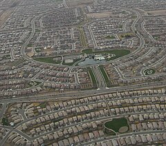
Maricopa is a city in the Gila River Valley in Arizona. With an estimated 51,977 residents as of 2018, Maricopa is the second most populous incorporated city in Pinal County and eighteenth most populous in Arizona. Maricopa forms part of the Phoenix metropolitan area.

South Mountain Park in Phoenix, Arizona is the largest municipal park in the United States, and one of the largest urban parks in North America and in the world. It has been designated as a Phoenix Point of Pride.

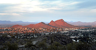
The South Mountains, known locally as simply South Mountain, is a mountain range in central Arizona in south Phoenix, Arizona. It is on public land managed by the city of Phoenix as South Mountain Park.

KSLX-FM is a Classic rock radio station serving the Phoenix, Arizona area. The Hubbard Broadcasting, Inc. outlet broadcasts at 100.7 MHz with an ERP of 100 kW and is licensed to Scottsdale, Arizona. KSLX simulcasts in digital HD Radio. Its studios are located on North 52nd Street west of Papago Park and its transmitter is in South Mountain Park.

Tempe Butte is the official name of an andesite butte of volcanic origin, located partially on Arizona State University's Tempe campus in Tempe, Arizona. It is often referred to by locals as A Mountain, after the 60-foot-tall (18 m) gold-painted letter 'A' near the top. Another name for the area, used by the City of Tempe, is Hayden Butte.

North/Northwest Phoenix is a region in the city of Phoenix, Arizona. While the area with this name has no official separate status, it usually refers to the Urban Villages of Paradise Valley, North Mountain, Deer Valley, Desert View, and North Gateway.

The Granite Mountain/Speculator Mine disaster of June 8, 1917, occurred as a result of a fire in a copper mine, and was the most deadly event in underground hard rock mining in United States history. Most men died of suffocation underground as the fire consumed their oxygen; a total of 168 miners were killed. The Butte, Montana copper mines were at full wartime production to support the US for the Great War. Miners had been seeking improved working conditions, as they were at high risk.
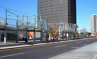
Thomas/Central Ave is a light rail station on Valley Metro Rail in Phoenix, Arizona, United States. It is the seventh stop southbound and the twenty-second stop northbound on the initial 20 mile starter line. The station is north of Thomas Road, and it can be accessed from both Thomas Road, at the south, and Catalina Drive, two blocks to the north. Catalina Drive is the south-boundary street for Park Central Mall.

Alhambra Elementary School District provides education for more than 14,000 students in the Phoenix and Glendale areas of Arizona. Alhambra has 15 schools. These schools educate students from kindergarten to eighth grade. The district feeds into Phoenix Union High School District.

The Gila Bend Mountains are a 35-mile (56 km) long mountain range of the north-central Sonoran Desert southwest of Phoenix, Arizona and in southwest Maricopa County.

The Belmont Mountains are a 25 mi (40 km) long, arid, low elevation mountain range about 50 mi west of Phoenix, Arizona in the northern Sonoran Desert, north of the Gila River. The range is in the south of a region of two parallel washes; the Bouse Wash flows northwest to the Colorado River, and the Centennial Wash flows southeast to meet the Gila River.
Pima Butte is a mountain summit in Pinal County, Arizona eight miles north of present-day Maricopa, Arizona. Pima Butte is 1,660 feet above sea level. As a significant landmark in the Gila Valley it was near the site of the 1857 Battle of Pima Butte, to which it gave its name.

The Daisy Mountain Potential Preserve is a 6 square miles (16 km2) undeveloped Arizona State Trust Land area straddling the communities of Anthem, Desert Hills, northern area of Phoenix and New River Arizona, open to the public if they have a State Land Department Recreation Permit. The form is at http://www.land.state.az.us/programs/natural/RecreationPermit.pdf. Residents of the surrounding area enjoy hiking, horse back riding, photography, bicycling, birding, and other recreational activities within the potential preserve. Motorized vehicles are restricted by Arizona State Trust Land and Maricopa County Dust regulations. There is no water due to limited precipitation over the desert landscape, though intermittent or seasonal washes do exist. There are no designated trails although the Maricopa County Regional Trail's Anthem Trailhead is near-by and a number of informal trails providing paths exist and can be used by mountain bikers, hikers and horse-riders. Plant life consists mostly of cacti and dry shrubbery. A portion of the potential preserve seems to be limited to residents of the Anthem Country Club only, though there is a county easement from the Maricopa County Regional Trail through the Country Club to the Daisy Mountain Arizona State Trust land. Visitors are encouraged to use their judgement as to avoid intrusion onto Country Club property.

Deer Valley or Deer Valley Village is one of the 15 urban villages that make up Phoenix, Arizona, United States. As of 2010, the population was 165,656, 25% of whom were under 18 years of age. The origin of the name is unclear; it first appeared on a 1921 General Land Office map of the area describing the valley created by Skunk Creek.
Lookout Mountain Preserve is a municipal park in the northern part of Phoenix, Arizona. It is supervised and maintained by the Parks and Recreation Department of the City of Phoenix as part of the Phoenix Mountains Preserve system of parks. The preserve offers scenic vistas and trails for hiking and mountain biking.


