North Witchford Rural District

Last updated
Position within Isle of Ely North Witchford RD 1935.png
Position within Isle of Ely

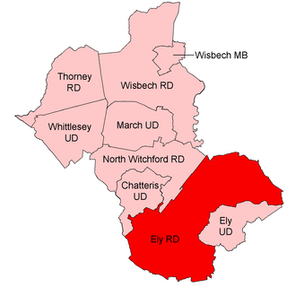
Coordinates: 52°22′19″N0°10′59″E / 52.372°N 0.183°E / 52.372; 0.183 North Witchford was a rural district in England from 1894 to 1974. It was named after the ancient hundred of North Witchford.

Geographic coordinate system Coordinate system

A geographic coordinate system is a coordinate system that enables every location on Earth to be specified by a set of numbers, letters or symbols. The coordinates are often chosen such that one of the numbers represents a vertical position and two or three of the numbers represent a horizontal position; alternatively, a geographic position may be expressed in a combined three-dimensional Cartesian vector. A common choice of coordinates is latitude, longitude and elevation. To specify a location on a plane requires a map projection.

Rural districts were a type of local government area – now superseded – established at the end of the 19th century in England, Wales, and Ireland for the administration of predominantly rural areas at a level lower than that of the administrative counties.

It was formed in 1894 under the Local Government Act 1894 based on the North Witchford rural sanitary district. It covered the parishes of Benwick, Doddington, Manea, Welches Dam and Wimblington. From 1894 to 1965 it was part of the administrative county of the Isle of Ely, and then Cambridgeshire and Isle of Ely.

Local Government Act 1894

The Local Government Act 1894 was an Act of the Parliament of the United Kingdom that reformed local government in England and Wales outside the County of London. The Act followed the reforms carried out at county level under the Local Government Act 1888. The 1894 legislation introduced elected councils at district and parish level.

Doddington, Cambridgeshire farm village in the United Kingdom

Doddington is a village and civil parish in the Isle of Ely, Cambridgeshire, 4 miles (6 km) between Chatteris and March.

Manea, Cambridgeshire village in the United Kingdom

Manea is a village and civil parish in the District of Fenland, Isle of Ely, Cambridgeshire, England.

It was abolished in 1974 under the Local Government Act 1972, and went on to form part of the district of Fenland

Local Government Act 1972 Act of Parliament in the United Kingdom

The Local Government Act 1972 is an Act of the Parliament of the United Kingdom that reformed local government in England and Wales on 1 April 1974.

Fenland District Non-metropolitan district in England

Fenland is a local government district in Cambridgeshire, England. Its council is based in March, and it covers the neighbouring market towns of Chatteris, Whittlesey and Wisbech; the last is often called the "capital of the fens".

Related Research Articles

Banbury Rural District

Banbury was a rural district in Oxfordshire, England from 1894 to 1974. It was formed under the Local Government Act 1894 from the bulk of the Banbury rural sanitary district, which had been divided among three counties. The Warwickshire part of the rural sanitary district formed the Farnborough Rural District, whilst the area in Northamptonshire formed the Middleton Cheney Rural District.

Chesterton Rural District

Chesterton was a rural district in Cambridgeshire, England from 1894 to 1974.

Kettering was a rural district in Northamptonshire in England from 1894 to 1974.

The Brixworth Rural District was a rural district in Northamptonshire, England from 1894 to 1974,. It was named after and administered from the village of Brixworth.

Ely Rural District rural district in England from 1894 to 1974

Ely was a rural district in England from 1894 to 1974. It was named after Ely, and surrounded it to the west and north. The district was created in 1894 under the Local Government Act 1894 from the Ely rural sanitary district. It formed part of the administrative county of the Isle of Ely from 1894 to 1965, when this was merged into Cambridgeshire and Isle of Ely.

Wisbech Rural District

Wisbech was a rural district in Cambridgeshire in England from 1894 to 1974.

Thorney Rural District

Thorney was a rural district in England from 1894 to 1974, situated to the east of Peterborough.

Norman Cross Rural District

Norman Cross was a rural district in Huntingdonshire from 1894 to 1974.

Boston was a rural district in Holland, Lincolnshire from 1894 to 1974. It was formed from the Boston rural sanitary district by the Local Government Act 1894 and did not include the municipal borough of Boston. The part of Boston RSD which was in Lindsey formed the Sibsey Rural District. In 1974, under the Local Government Act 1972, it was merged with Boston in a new borough of Boston.

East Elloe was a rural district in Holland in Lincolnshire from 1894 to 1974.

Spalding was a rural district in Holland in Lincolnshire, England from 1894 to 1974.

Halstead was a rural district in Essex, England from 1894 to 1974. It was created by the Local Government Act 1894 as a successor to the Halstead rural sanitary district.

Flaxton was a rural district in the North Riding of Yorkshire from 1894 to 1974. It was formed under the Local Government Act 1894 from the part of the York Rural Sanitary District which was in the North Riding.

Northampton was a rural district in Northamptonshire, England from 1894 to 1974.

Bingham Rural District

Bingham was a rural district in Nottinghamshire, England from 1894 to 1974.

Drayton or Market Drayton was a rural district in Shropshire, England from 1894 to 1974. It was created by the Local Government Act 1894 under the name 'Drayton', from that part of the Market Drayton rural sanitary district which was in Shropshire.

Gainsborough Rural District

Gainsborough was rural district in Lincolnshire, Parts of Lindsey from 1894 to 1974.

Freebridge Lynn Rural District

Freebridge Lynn Rural District was a rural district in Norfolk, England from 1894 to 1974.

Marshland Rural District

Marshland Rural District was a rural district in Norfolk, England from 1894 to 1974.

Huntingdon Rural District

Huntingdon was a rural district in Huntingdonshire from 1894 to 1974, lying to the north and west of urban Huntingdon. It was formed in 1894 under the Local Government Act 1894 from the earlier Huntingdon rural sanitary district.

References