
The Northwest Territories is a federal territory of Canada. At a land area of approximately 1,144,000 km2 (442,000 sq mi) and a 2016 census population of 41,786, it is the second-largest and the most populous of the three territories in Northern Canada. Its estimated population as of 2019 is 44,895. Yellowknife became the territorial capital in 1967, following recommendations by the Carrothers Commission.
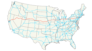
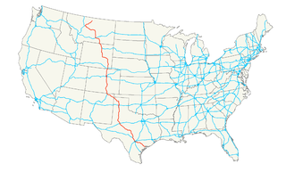
Interstate 80 (I-80) is an east–west transcontinental freeway in the United States that runs from downtown San Francisco, California, to Teaneck, New Jersey, in the New York City Metropolitan Area. The highway was designated in 1956 as one of the original routes of the Interstate Highway System. Its final segment was opened to traffic in 1986. It is the second-longest Interstate Highway in the United States, following I-90. The Interstate runs through many major cities including Oakland, Sacramento, Reno, Salt Lake City, Omaha, Des Moines, and Toledo, and passes within 10 miles (16 km) of Chicago, Cleveland, and New York City.

Numbered highways in Canada are split by province, and a majority are maintained by their province or territory transportation department. All highways in Canada are numbered except for three in the Northwest Territories, one in Alberta, one in Ontario, and one in Quebec. Ontario's 7000 series are not marked with their highway number but have been assigned one by the Ministry of Transportation. A number of highways in all provinces are better known locally by their name rather than their number. Some highways have additional letters added to their number: A is typically an alternate route, B is typically a business route, and other letters are used for bypass (truck) routes, connector routes, scenic routes, and spur routes. The territory of Nunavut has no highways.

U.S. Route 14, an east–west route, is one of the original United States highways of 1926. It currently has a length of 1,398 miles (2,250 km), but it had a peak length of 1,429 miles (2,300 km). For much of its length, it runs roughly parallel to Interstate 90.
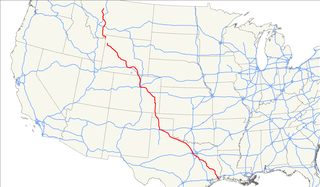
U.S. Route 287 (US 287) is a north–south United States highway. It is 1,791 miles (2,882 km) long. It serves as the major truck route between Fort Worth and Amarillo, Texas, and between Fort Collins, Colorado, and Laramie, Wyoming. The highway is broken into two segments by Yellowstone National Park, where an unnumbered park road serves as a connector.
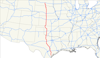
U.S. Route 69 (US 69) is a major north–south United States highway. When it was first created, it was only 150 miles (241 km) long, but it has since been expanded into a Minnesota to Texas cross-country route. The highway's southern terminus is in Port Arthur, Texas at an intersection with State Highway 87. Its northern terminus is in Albert Lea, Minnesota at Minnesota State Highway 13.
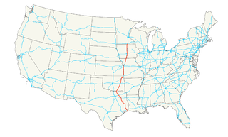
U.S. Route 183 (US 183) is a north–south United States highway. US 183 was the last U.S. Route to be completely paved. The 20-mile (32 km) segment in Loup County, Nebraska, north of Taylor, was unpaved until 1967. The highway's southern terminus is in Refugio, Texas, at the southern intersection of U.S. Highway 77 and Alternate US 77. Its northern terminus is in Presho, South Dakota, at an intersection with Interstate 90. US 183 and Alt US 77 overlap for their final 80 miles (130 km) between Cuero and Refugio.

The Liard Highway, designated Highway 77 in British Columbia and Highway 7 in the Northwest Territories, is a highway in Canada which forms the sole road connection between B.C. and the Northwest Territories.

U.S. Route 43 (US 43) is a 410-mile-long (660 km) north–south United States Highway in the East South Central States of Alabama and Tennessee. It travels from Prichard, Alabama to Columbia, Tennessee. The highway's southern terminus is in Prichard, at an intersection with US 90. Its northern terminus is in Columbia, Tennessee, at an intersection with US 31/US 412/US 412 Bus.
U.S. Highway 87 is a north–south United States highway that runs for 1,998 miles (3,215 km) from northern Montana to southern Texas. Most of the portion from Billings, Montana, to Raton, New Mexico, is co-signed along Interstates 90 and 25. It is also co-signed along the majority of Interstate 27 in Texas.
U.S. Route 421 (US 421) is a spur route of U.S. 21. It runs for 941 miles (1,514 km) from Fort Fisher, North Carolina south of Wilmington to Michigan City, Indiana at U.S. 20.
State Highway 6 runs from the Red River, the Texas–Oklahoma boundary, to northwest of Galveston, where it is known as the Old Galveston Highway. In Sugar Land and Missouri City, it is known as Alvin-Sugarland Road and runs perpendicular to I-69/US 59. In the Houston area, it runs north to FM 1960, then northwest along US Highway 290 to Hempstead, and south to Westheimer Road and Addicks, and is known as Addicks Satsuma Road. In the Bryan–College Station area, it is known as the Earl Rudder Freeway. In Hearne, it is known as Market Street. In Calvert, it is known as Main Street. For most of its length, SH 6 is not a limited-access road.
The Mackenzie Highway is a Canadian highway in northern Alberta and the Northwest Territories. It begins as Alberta Highway 2 at Mile Zero in Grimshaw, Alberta. After the first 4.0 km (2.5 mi), it becomes Alberta Highway 35 for the balance of its length through Alberta and then becomes Northwest Territories Highway 1.
U.S. Route 1 (US 1) in the U.S. state of Georgia, which is concurrent for almost its entire length with State Route 4 (SR 4), is a highway traversing south-to-north through portions of Charlton, Ware, Bacon, Appling, Toombs, Emanuel, Jefferson, and Richmond counties in the southeastern and east-central parts of the state. In Georgia, the highway originates at US 1/US 23/US 301/SR 15 at the St. Marys River and the Florida state line, where SR 4 and SR 15 reach their southern terminus. It travels to its northern terminus at US 1/US 25/US 78/US 278/SC 121 at the Savannah River and the South Carolina state line in Augusta. Here, SR 10 reaches its eastern terminus, and SR 121 reaches its northern terminus.

Northeastern Ontario is a secondary region of Northern Ontario which lies north of Lake Huron and east of Lake Superior.

State Route 17 (SR 17) is a 294-mile-long (473 km) state highway that travels south-to-north through portions of Chatham, Effingham, Screven, Jenkins, Burke, Jefferson, Warren, McDuffie, Wilkes, Elbert, Hart, Franklin, Stephens, Habersham, White, and Towns counties in the east-central and northeastern parts of the U.S. state of Georgia. The highway connects Interstate 16 (I-16) in Bloomingdale to the North Carolina state line, northwest of Hiawassee, via Millen, Louisville, Wrens, Thomson, Washington, Elberton, Royston, Toccoa, Clarkesville, and Hiawassee.
Maryland Route 140 is a 49-mile (79 km) state highway in the U.S. state of Maryland.
Highway 943 is a provincial highway in the northwest region of the Canadian province of Saskatchewan. It runs from the settlement of Meetoos, where it continues as Highway 698, to Highway 942 northwest of Big River. Highway 943 is about 69 km (43 mi) long.

Alberta Provincial Highway No. 35, commonly referred to as Highway 35, is a north–south highway in northwest Alberta, Canada that forms a portion of the Mackenzie Highway. Highway 35 is about 464 kilometres (288 mi) long.