Norwood, London may refer to:
South Norwood Country Park is a park in South Norwood, close to Elmers End station, mainly in the London Borough of Croydon. It is a 47 hectare green space which opened in 1989. The park is a mix of countryside and parkland, and land formerly used for sewage farms serving the growing London population.
South Norwood Lake and Grounds is a park in South Norwood in the London Borough of Croydon. The main entrance is in Woodvale Avenue while other entrances are located in Auckland Road and Sylvan Road. The area measures up to 281⁄2 acres 11.53 hectares.
South Norwood Leisure Centre is a leisure centre located on Portland Road in South Norwood in Croydon, London. It contains a 25m sized swimming pool with seating for spectators. The centre is managed by Fusion Lifestyle and Sport Croydon.
Norwood Park is a 13.3 hectare park located in West Norwood. The park is bordered by Elder Road, Central Hill and Salter's Hill in South East London in the London Borough of Lambeth.
West Norwood railway station is in the London Borough of Lambeth in West Norwood, south London. It is 7 miles 2 chains (11.3 km) measured from London Victoria. The station, and all trains serving it, are operated by Southern, and it lies in Travelcard Zone 3. Services from platform 1 go to London Victoria and London Bridge via Tulse Hill. Services from platform 2 operate to more varied destinations, including West Croydon and London Bridge via Crystal Palace.
West Norwood Cemetery is a 40-acre (16 ha) cemetery in West Norwood in London, England. It was also known as the South Metropolitan Cemetery. One of the first private landscaped cemeteries in London, it is one of the "Magnificent Seven" cemeteries of London, and is a site of major historical, architectural and ecological interest.
Norwood Road is a 2.6 hectare nature reserve in March in Cambridgeshire. It is managed by the Wildlife Trust for Bedfordshire, Cambridgeshire and Northamptonshire.
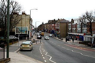
Norwood Green is a place in the London Borough of Ealing in London, England. It is a suburban development centred 10.7 miles (17.2 km) west of Charing Cross and 4 miles (6.4 km) ENE of Heathrow Airport.
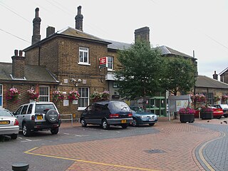
Norwood Junction railway station is a National Rail station in South Norwood in the London Borough of Croydon, south London and is in Travelcard Zone 4. It is 8 miles 55 chains (13.98 km) down the line from London Bridge.
Norwood New Town is a largely residential, former working-class enclave within the larger district of Upper Norwood in Southeast London. It is within the London Borough of Croydon. In common with the neighbouring districts of West Norwood, South Norwood and Upper Norwood, it is named after the contraction of the Great North Wood, which once occupied this area.
The Great North Wood was a natural oak woodland that covered most of the area of raised ground starting some four miles (6.4 km) south of central London, covering the Sydenham Ridge and the southern reaches of the River Effra and its tributaries. At its full extent, the wood's boundaries stretched almost as far as Croydon and as far north as Camberwell.

Norwood, known legally as Norwood-Ravenswood, is a UK charity established in 1785 in the East End of London. Its name comes from its long running home for Jewish children, Norwood Hall, in the south London suburb of West Norwood which opened in 1863 and closed in 1961.
| This disambiguation page lists articles associated with the title Norwood, London. If an internal link led you here, you may wish to change the link to point directly to the intended article. |
The London Borough of Croydon is a London borough in south London, England and is part of Outer London. It covers an area of 87 km2 (33.6 sq mi) and is the largest London borough by population. It is the southernmost borough of London. At its centre is the historic town of Croydon from which the borough takes its name. Croydon is mentioned in Domesday Book, and from a small market town has expanded into one of the most populous areas on the fringe of London. Croydon is the civic centre of the borough. The borough is now one of London's leading business, financial and cultural centres, and its influence in entertainment and the arts contribute to its status as a major metropolitan centre.
Crystal Palace is an area in South London, England, named after the Crystal Palace Exhibition building which stood in the area from 1854 until it was destroyed by fire in 1936. Approximately 7 miles southeast of Charing Cross, it includes one of the highest points in London, at 367 feet (112 m), offering views over the capital. The area has no defined boundaries and straddles five London boroughs and three postal districts, although there is a Crystal Palace electoral ward and Crystal Palace Park in the London Borough of Bromley. It is contiguous with Anerley, Dulwich Wood, Gipsy Hill, Penge, South Norwood, Sydenham and Upper Norwood.
Upper Norwood is an area of south-east London within the London Boroughs of Bromley, Croydon, Lambeth and Southwark. It is north of Croydon and is synonymous with the Crystal Palace area.
Streatham Hill railway station is one of three stations serving the district of Streatham, in the London Borough of Lambeth. It is 5 miles 57 chains (9.2 km) measured from London Victoria. The wooden station building at street level faces the busy Streatham High Road (A23) at the junction with Leigham Court Road. Services are operated by Southern.
Monks Orchard is a suburb on the edge of the London Borough of Croydon, England. It is a town situated about 10 miles (16.1 km) south south-east of Charing Cross.
Woodside is a neighbourhood in the London Borough of Croydon located between Addiscombe and South Norwood.
Anerley is an area of south east London, within the London Borough of Bromley. It is located west of Bromley and is 7.0 miles (11 km) south south-east of Charing Cross. The district is the former site of The Crystal Palace.
Gipsy Hill is an area in south London within the London Borough of Lambeth. It borders the London Boroughs of Southwark and Croydon.
Ringway 2 was the second innermost of the series of four London Ringways, ring roads planned in the 1960s to circle London at various distances from the city centre. They were part of a comprehensive scheme developed by the Greater London Council (GLC) to alleviate traffic congestion on the city's road system by providing high speed motorway-standard roads within the capital linking a series of radial roads taking traffic into and out of the city. The scheme was cancelled in 1973.
The A2022 is a non-primary road in England. It runs south-west into the foothills of the North Downs from West Wickham in the London borough of Bromley through Selsdon, Sanderstead, Addington, Purley, the Woodcote part of that town, Banstead in Surrey and Epsom Downs through which it descends to a similar altitude as at its beginning to end at Epsom also in Surrey.
The A215 is an A road in South London, starting at Elephant and Castle and finishing around Shirley. It runs through the London Boroughs of Lambeth, Southwark and Croydon.
Selhurst is a London suburb in the Borough of Croydon 7.8 miles (12.6 km) south-south-east of Charing Cross. The area is bounded by South Norwood, Croydon and Thornton Heath. The home stadium of Crystal Palace Football Club, called Selhurst Park, is sited at the northern end of the neighbourhood. The BRIT School, a performing arts school operated by The BRIT foundation, more commonly known for the BRIT Awards, is located in the area.