A gravel pit is an open-pit mine for the extraction of gravel. Gravel pits often lie in river valleys where the water table is high, so they may naturally fill with water to form ponds or lakes. Old, abandoned gravel pits are normally used either as nature reserves, or as amenity areas for water sports, landfills and walking. In addition, many gravel pits in the United Kingdom have been stocked with freshwater fish such as the common carp to create coarse fishing locations. Gravel and sand are mined for concrete, construction aggregate and other industrial mineral uses.

Gold mining is the resource extraction of gold by mining.

Shuswap Lake Provincial Park is a provincial park in British Columbia, Canada.

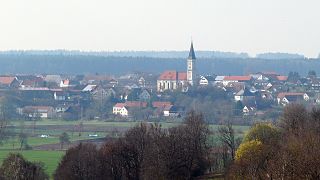
Krumbach is a town with 13,000 residents in the district Günzburg in Swabia, Bavaria, Germany. It is the second biggest town in the district.
Maberly is a tiny coastal hamlet at the end of route 238-II on the Bonavista Peninsula on the island of Newfoundland with a permanent year-round population of about 20. In the 1921 census, there were 83 inhabitants. It has long been associated with nearby Elliston, being about 3 km from Elliston Centre by road, and was officially annexed by that town in the 1960s. Driving from Elliston Centre to Maberly, you pass through Sandy Cove and the Neck.

Browning Pond is located in Oakham and Spencer, Massachusetts. This 89-acre (360,000 m2) great pond forms the headwaters of the Seven Mile River. It is part of the Chicopee River Watershed.

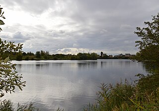
Sevenoaks Gravel Pits is a 73.7-hectare (182-acre) biological Site of Special Scientific Interest on the northern outskirts of Sevenoaks in Kent. It is managed by Kent Wildlife Trust as the Sevenoaks Wildlife Reserve and Jeffery Harrison Visitor Centre.
Eye Green Local Nature Reserve is a 12 hectare Local Nature Reserve in Eye Green in Cambridgeshire. It was managed by the Wildlife Trust for Bedfordshire, Cambridgeshire and Northamptonshire until September 2016, when management was transferred to its owner, Peterborough City Council. A small part is also in the Eye Gravel Pit geological Site of Special Scientific Interest.

Decoy Pit, Pools and Woods is a 20.27 hectares Site of Special Scientific Interest (SSSI) between Little Heath and Aldermaston Soke in the civil parish of Aldermaston in the English county of Berkshire, notified in 1993.

Swan Lane Open Space is a public park in Whetstone in the London Borough of Barnet. It is the smallest of Barnet's sixteen 'Premier Parks'. It has a children's playground, a café, and a pond which was formerly used for model boating but is now covered with reeds and water plants. Much of it is mown grass and trees, including giant redwoods and a Cedar of Lebanon, but it also has more natural areas managed for nature conservation.

Attenborough Nature Reserve is a nature reserve at Attenborough, Nottinghamshire, England, located 7 Kilometres south west of Nottingham city centre. It is managed by Nottinghamshire Wildlife Trust in partnership with the site's owners, Cemex, supported by Broxtowe Borough Council. At its centre is a building called Attenborough Nature Centre, comprising visitor services and educational facilities.
The Danube-Gunz interglacial, Danube-Gunz warm period (Donau-Günz-Warmzeit), often just Danube-Gunz, or also Uhlenberg interglacial (Uhlenberg-Warmzeit) are historical terms for a hypothetical warm period of the Pleistocene in the Alps, between the Danube and Gunz glacials. The interglacial was defined as the erosion phase that followed the Danube glacial and preceded the Gunz stage. It is therefore represented by the gap between the two depositions that are attributed to the two cold periods; in the type regions of the two glacial there are various depositions. In the area of the Iller-Lech Plateau they lie between the Lower Deckschotter of the Zusam Plateau and the Intermediate Deckschotter (Zwischenschottern); in the region of the Salzach Glacier between the Eichwald Schotter and the Older Deckenschotter ; and the area of Traun and Enns between the Prägünz Schotter and the Older Deckenschotter. The erosion phase linked with this interglacial is very distinct and the composition of the gravels (Schotter) in the area east of the Rhine Glacier changes markedly.
The Gunz-Haslach interglacial and the Gunz-Haslach warm period (Günz-Haslach-Warmzeit) are historical terms for a hypothetical warm period of the Pleistocene in the Alpine region, between the Gunz and Haslach glaciations. The interglacial was defined as the erosion phase which follows the Günz and precedes the Haslach Glacial Stage. It thus corresponds to the stratigraphic gap between the Zeil gravels in Swabia and Haslach gravels northeast of the Rhine Glacier.
Fingringhoe Wick is a 48.6 hectare nature reserve in Fingringhoe in Essex. It is managed by the Essex Wildlife Trust, which runs a visitor centre on the site. It is part of the Colne Estuary Site of Special Scientific Interest, Ramsar site and Nature Conservation Review site.

Great Holland Pits is a 16.2 hectare nature reserve east of Great Holland in Essex. It is managed by the Essex Wildlife Trust.

Claytonia is an unincorporated community in Owyhee County in the southwestern part of the U.S. state of Idaho.

The Mosbrucher Weiher, also called the Mosbrucher Maar, is a silted up maar east of the municipal boundary of the village of Mosbruch in the county Vulkaneifel in Germany. It is located immediately at the foot of the 675-metre-high Hochkelberg, a former volcano. The floor of the maar is in the shape of an elongated oval and is about 700×500 metres in size, its upper boundary has a diameter of about 1,300 × 1,050 metres. This makes the Mosbrucher Maar the third largest of the maars in the western Eifel region. The Üßbach stream flows past and close to the Mosbrucher Weiher.
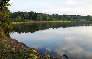
The Haidenweiher is a large pond about 1.3 kilometres southwest of the village of Dreifelden in the county of Westerwaldkreis in Germany. It has a surface area of c. 30 hectares and is the second largest of the Westerwald Lakes. It is linked to the Dreifelder Weiher by a drainage ditch and is used today for breeding fish. The pond was designated as a nature reserve in 1979 and is surrounded by dense woods. Rare bird species nest along its shores, especially waders.