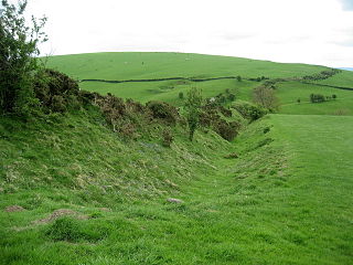
Offa's Dyke is a large linear earthwork that roughly follows the border between England and Wales. The structure is named after Offa, the Anglo-Saxon king of Mercia from AD 757 until 796, who is traditionally believed to have ordered its construction. Although its precise original purpose is debated, it delineated the border between Anglian Mercia and the Welsh kingdom of Powys.
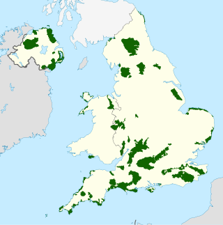
An Area of Outstanding Natural Beauty is an area of countryside in England, Wales, and Northern Ireland, that has been designated for conservation due to its significant landscape value. Areas are designated in recognition of their national importance by the relevant public body: Natural England, Natural Resources Wales, and the Northern Ireland Environment Agency respectively. In place of AONB, Scotland uses the similar national scenic area (NSA) designation. Areas of Outstanding Natural Beauty enjoy levels of protection from development similar to those of UK national parks, but unlike national parks the responsible bodies do not have their own planning powers. They also differ from national parks in their more limited opportunities for extensive outdoor recreation.
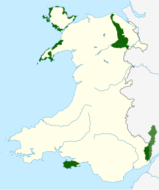
There are five Areas of Outstanding Natural Beauty (AONBs) in Wales. AONBs are areas of countryside that have been designated for statutory protection, due to their significant landscape value, by initially the Government of the United Kingdom and later Welsh devolved bodies. Of the current five areas designated, four are wholly in Wales, with another spanning the Wales-England border, and in total AONBs account for 4% of Wales' land area.

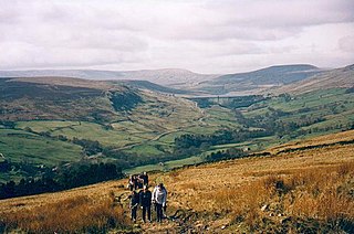
Offa's Dyke Path is a long-distance footpath loosely following the Wales–England border. Officially opened on 10 July 1971, by Lord Hunt, it is one of Britain's National Trails and draws walkers from throughout the world. About 60 miles (97 km) of the 177-mile (285 km) route either follows, or keeps close company with, the remnants of Offa's Dyke, an earthwork traditionally thought to have been constructed in the late 8th century on the orders of King Offa of Mercia.
South Shropshire was, between 1974 and 2009, a local government district in south west Shropshire, England.

Newcastle is a village in the rural south west of Shropshire, England. It lies at the confluence of the River Clun and the Folly Brook, 3 miles west of the small town of Clun. The B4368 runs through the village, on its way between Craven Arms in Shropshire to Newtown in Powys.

The Shropshire Hills is a designated Area of Outstanding Natural Beauty (AONB) in Shropshire, England. It is located in the south of the county, extending to its border with Wales. Designated in 1958, the area encompasses 802 square kilometres (310 sq mi) of land primarily in south-west Shropshire, taking its name from the upland region of the Shropshire Hills. The A49 road and Welsh Marches Railway Line bisect the area north–south, passing through or near Shrewsbury, Church Stretton, Craven Arms and Ludlow.

The Clwydian Range is a series of hills in the north-east of Wales that runs from Llandegla in the south to Prestatyn in the north; the highest point is 554 m (1,818 ft) Moel Famau. The range forms the north-western part of the Clwydian Range and Dee Valley Area of Outstanding Natural Beauty.
The Nidderdale AONB is an Area of Outstanding Natural Beauty in North Yorkshire, England, bordering the Yorkshire Dales National Park to the east and south. It comprises most of Nidderdale itself, part of lower Wharfedale, the Washburn valley and part of lower Wensleydale, including Jervaulx Abbey and the side valleys west of the River Ure. It covers a total area of 233 square miles (600 km2). The highest point in the Nidderdale AONB is Great Whernside, 704 metres (2,310 ft) above sea level, on the border with the Yorkshire Dales National Park.

The Wye Valley Area of Outstanding Natural Beauty is an internationally important protected landscape straddling the border between England and Wales.
The North Wales Path is a long-distance walk of some 60 miles (97 km) that runs close to the coast of northern Wales between Prestatyn in the east and Bangor in the west. Parts of it overlap with the Wales Coast Path. The path runs along parts of the Clwydian Range and Dee Valley Area of Outstanding Natural Beauty (AONB). The path was devised, implemented and maintained by the then Countryside Council for Wales and the three councils of: Gwynedd, Conwy, and Denbighshire.

Llanferres is a village and community in the county of Denbighshire in Wales. At the 2001 Census the population of the village was recorded as 676, increasing to 827 at the 2011 census.

The Clwyd-Powys Archaeological Trust(CPAT) (Welsh: Ymddiriedolaeth Archeolegol Clwyd-Powys(YACP)) is an educational charity which was established in 1975. Its objective is ‘to advance the education of the public in archaeology’. CPAT is one of four Welsh Archaeological Trusts (WATs) which work to help protect, record and interpret all aspects of the historic environment. This includes providing advice to local authorities on archaeology and planning, undertaking archaeological projects for private- and public-sector clients, and delivering a programme of community archaeology events and activities.
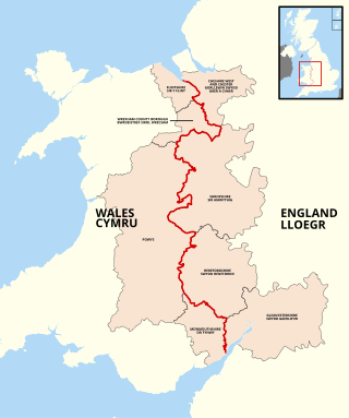
The England–Wales border, sometimes referred to as the Wales–England border or the Anglo-Welsh border, runs for 160 miles (260 km) from the Dee estuary, in the north, to the Severn estuary in the south, separating England and Wales.

Offa is a community and electoral ward in Wrexham County Borough, Wales, covering most of the south-western portion of the city of Wrexham. It is bordered by the communities of; Rhosddu, and Caia Park to the north, Abenbury to the east, Esclusham, and Marchwiel to the south, and Broughton, Coedpoeth, and Gwersyllt to the west.

The Wales Coast Path is a designated long-distance trail which follows, or runs close to, the coastline of Wales.

ITV Cymru Wales, previously known as Harlech Television and HTV Wales, is the ITV franchise for Wales. The new separate licence began on 1 January 2014, replacing the long-serving dual franchise region serving Wales and the West of England.

The England Coast Path is a proposed long-distance National Trail that will follow the coastline of England. When complete, it will be around 2,700 miles (4,300 km) miles long.
The North Wales Metro is a rail and bus transport improvement programme in north Wales. Styled as a "Metro", it is conceptually a multi-modal system with a combination of bus, heavy rail, and light rail services. It was initially focused on linking major settlements and employment areas of the north-east of Wales with the North West of England, with its hubs located in Wrexham, Chester and Deeside, although the programme has since expanded, with proposals extending to Anglesey in the north-west of Wales. The existing Borderlands line forms a core rail component of the network, where projects to increase connections, integrated access, and service frequency between Wrexham, Deeside and Liverpool are centred upon. The proposals were put forward in 2016 as is part of Welsh Labour's plan for north Wales. Labour has pledged to open the system by 2035. The proposals were included in the 2018 Wales & Borders franchise contest. It is the second of the three regional metros proposed by the Welsh Government to go ahead, after the South Wales Metro, and before the Swansea Bay and West Wales Metro. The project is described to be in its initial phases.
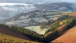
The Clwydian Range and Dee Valley is a designated Area of Outstanding Natural Beauty (AONB) and proposed national park, located in north-east Wales, covering the Clwydian Range, and the valley of the River Dee.