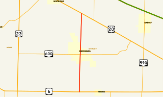
State Route 300 is a 6.33-mile (10.19 km) long north–south state highway in northwestern Ohio, a U.S. state. The southern terminus of SR 300 is at a T-intersection with U.S. Route 6 (US 6) approximately 1.50 miles (2.41 km) west of the village of Helena. Its northern terminus is at US 20 just over 2.50 miles (4.02 km) southeast of Woodville.

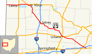
State Route 161 (SR 161) is an east–west state highway in central Ohio. Its western terminus is in Mutual at State Route 29 and its eastern terminus is near Alexandria at State Route 37. It is 57.46 miles (92.47 km) long. State Route 161 passes through Columbus, Ohio's capital, and a variety of towns including Plain City, Dublin, and New Albany.

State Route 373 is north–south state highway in the southern portion of Ohio. Its southern terminus is just over eleven miles (18 km) north of Ironton at SR 93 at the hamlet of Bartles, and its northern terminus is at about three miles (4.8 km) to the north of its southern terminus, also at SR 93.

State Route 621 is a north–south state highway in the central part of the U.S. state of Ohio. The southern terminus of SR 621 is at U.S. Route 36 approximately two and a half miles (4.0 km) northeast of Coshocton, and its northern terminus is adjacent to the North Appalachian Experimental Watershed Station, just north of its intersection with White Eyes Township Road 188, about 5 miles (8.0 km) northwest of the hamlet of Fresno. Continuing north after SR 621 ends is County Road 190.

State Route 559 is a north–south state highway in the central portion of the U.S. state of Ohio. The southern terminus of the highway is at the signalized junction of State Route 29 and State Route 4 in downtown Mechanicsburg. Its northern terminus is at a T-intersection with State Route 287 approximately 4 miles (6.4 km) northwest of North Lewisburg.

State Route 238 was a short northwest–southeast state highway in the southwestern portion of Ohio. At just over 1 mile (1.6 km) in length, State Route 238 had its southern terminus at the U.S. Route 62 /SR 3 concurrency less than 1 mile (1.6 km) southeast of Bloomingburg. Its northern terminus was at SR 38 in the downtown of the Fayette County village.

State Route 528 (SR 528) is north–south state highway in the northeastern portion of the U.S. state of Ohio. The southern terminus is at an intersection with U.S. Route 422 (US 422) and SR 88 in the village of Parkman, about 6½ miles south of Middlefield, and its northern terminus is at U.S. Route 20 about 2 miles (3.2 km) north of Madison. The entire highway is a two-lane highway, that passes through woodland and farmland. SR 528 was commissioned in the mid-1930s on the same route. The highway was extended in 1940, to US 20, replacing another state route. In the mid-1960s the route was extended south to US 422.

State Route 507 is a short east–west state route in western Ohio, located entirely in the northern portion of Champaign County. The western terminus of SR 507 is at U.S. Route 68 (US 68) one mile (1.6 km) south of West Liberty. Its eastern terminus is at SR 245 near the Ohio Caverns approximately four miles (6.4 km) southeast of West Liberty.

State Route 814 is a 3-mile (5 km), north–south state route in western Ohio. The entirety of SR 814 lies within Champaign County. The southern terminus of SR 814 is at U.S. Route 36 (US 36) approximately three miles (4.8 km) east of Urbana, and its northern terminus is at SR 296 about five and a half miles (8.9 km) northeast of Urbana. The SR 814 designation came about during the early 1980s, being re-numbered from State Route 714 following a major issue with SR 714 shields continually disappearing.

State Route 566 is a north–south state highway in eastern Ohio, a U.S. state. Located exclusively in northern Noble County, SR 566 has its southern terminus at SR 147, at a T-intersection 1.25 miles (2.01 km) north of the unincorporated community of Mount Ephraim. Its northern terminus is at another T-intersection, this time with SR 285 approximately 1.25 miles (2.01 km) south of the village of Senecaville.

State Route 288 (SR 288) is a 6.82-mile (10.98 km) long east–west state highway in the northern portion of the U.S. state of Ohio. The western terminus of SR 288 is at a T-intersection with SR 309 about 3 miles (4.8 km) southwest of Galion. Its eastern terminus is also at a T-intersection, this time with SR 97 approximately 5.50 miles (8.85 km) northwest of Lexington.

State Route 746 is a north–south thirteen-mile-long (21 km) state highway located in central Ohio, a U.S. state. Its southern terminus is at U.S. Route 42 (US 42) approximately three miles (4.8 km) north of Ashley, and its northern terminus is at SR 309 in Caledonia.

State Route 716 is a state highway in the western part of the U.S. state of Ohio. Its southern terminus is at SR 705 in the village of Osgood in northeastern Darke County. The northern terminus of SR 716 is at SR 274 in the village of Chickasaw in southeastern Mercer County. For its entire length, SR 716 runs parallel to, and approximately four miles (6.4 km) to the east of, U.S. Route 127.
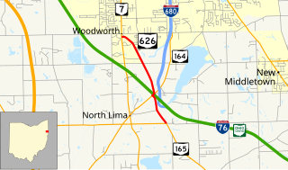
State Route 626 is a north–south state highway in the northeastern portion of the U.S. state of Ohio. The southern terminus of SR 626 is at SR 165 approximately one and a half miles (2.4 km) southeast of the hamlet of North Lima. Its northern terminus is at SR 7 nearly two miles (3.2 km) south of the township of Boardman.

State Route 692 was a short north–south state route in southern Ohio that was located entirely within Meigs County. The southern terminus of SR 692 was at SR 143 approximately three miles (4.8 km) northwest of the hamlet of Harrisonville. Its northern terminus was at SR 681 near the hamlet of Pageville. In 2013, the Ohio Department of Transportation (ODOT) removed SR 692 from the state highway system by making the route north of Pageville an extension of SR 684 and the remainder being transferred to Meigs County's jurisdiction.

Ohio State Route 691 is a north–south state route in southern Ohio. The entirety of SR 691 is within Athens County. Its southern terminus is at OH 56 about 1.5 miles (2.4 km) northwest of New Marshfield, and its northern terminus is at an interchange with US 33 and SR 78 in Nelsonville.

State Route 282 is a north–south state highway in northeastern Ohio, a U.S. state. The southern terminus of SR 282 is at a T-intersection with SR 305 near the hamlet of Nelson. Its northern terminus is also at a T-intersection, this time with the four-lane divided U.S. Route 422 (US 422) approximately two miles (3.2 km) southeast of Parkman. SR 282 primarily serves as an access route for Nelson Kennedy Ledges State Park. For its duration, the highway is also known as Nelson Ledge Road.

State Route 191 is a north–south state highway in northwestern Ohio, a U.S. state. SR 191's southern terminus is at U.S. Route 6 (US 6) approximately four miles (6.4 km) south of Stryker. Its northern terminus is at the concurrency of US 20A and US 127 in downtown West Unity. Between its southern terminus and Stryker, SR 191 runs parallel to, and to the east of, the Tiffin River.
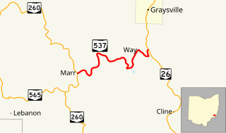
State Route 537 is a short east–west state highway in southeastern Ohio. At a length of just shy of five miles (8.0 km), SR 537 is located entirely within southwestern Monroe County. The state route's western terminus is at SR 260 approximately three and a half miles (5.6 km) southeast of the unincorporated community of Sycamore Valley, and its eastern terminus is at SR 26 one mile (1.6 km) south of the village limits of Graysville.
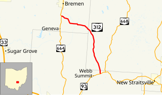
State Route 312 (SR 312) is a north–south state highway located in the southern portion of the U.S. state of Ohio. SR 312 runs from its southern terminus at a T-intersection with SR 93 approximately 4.25 miles (6.84 km) northeast of Logan to its northern terminus at a T-intersection with SR 664 nearly 1.25 miles (2.01 km) south of Bremen.