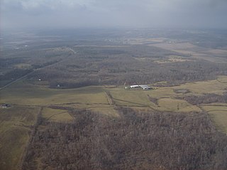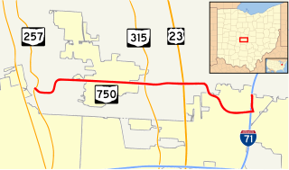
State Route 750 is an east–west state highway located in central Ohio. The western terminus of the state highway is at a signalized intersection with SR 257 nearly 2.5 miles (4.0 km) west of Powell, just outside the Columbus Zoo and Aquarium. The highway travels east to Highbanks Metro Park and Polaris Fashion Place. The eastern terminus of SR 750 is at Interstate 71 (I-71) in the far northern reaches of the city of Columbus. The route was designated in 1937, and both termini were rerouted. The eastern terminus was extended east in 1997, and the western terminus was rerouted south in 2007.
State Route 55 (SR 55) is an east–west state route in western Ohio. Its western terminus is near the town of Laura at SR 571, and its eastern terminus is south of downtown Urbana at U.S. Route 68 (US 68).

State Route 287 (SR 287) is a 13.69-mile-long (22.03 km) east–west state highway in the western portion of the U.S. state of Ohio. The western terminus of SR 287 is at SR 245 nearly 1.75 miles (2.82 km) east of West Liberty. Its eastern terminus is at an interchange with U.S. Route 33 (US 33) about 5.25 miles (8.45 km) northeast of North Lewisburg that dually serves as the southern terminus of SR 739.

State Route 540 (SR 540) is an east–west state highway in the western portion of the U.S. state of Ohio. SR 540 has its western terminus in downtown Bellefontaine at a signalized intersection with U.S. Route 68 (US 68) and SR 47. Its eastern terminus is at a T-intersection with SR 292 approximately 3.50 miles (5.63 km) southwest of West Mansfield.

State Route 775 (SR 775) is a 31.49-mile-long (50.68 km) north–south state route in the southern portion of the U.S. state of Ohio. Its southern terminus is on the East Huntington Bridge with the unmarked West Virginia Route 106 south of Proctorville, and its northern terminus is at SR 141 nearly 7 miles (11 km) west of Gallipolis. Most of the route is a rural two-lane highway and passes through woodland. The same of its path, SR 775, passing through the Wayne National Forest. The route was commissioned in the mid-1930s and the highway was paved by the late 1950s. The route was extended in the mid-2000s, to its current southern terminus.

State Route 353 (SR 353) is an east–west state highway in southwestern Ohio, a U.S. state. Its western terminus is at U.S. Route 62 (US 62) about four and a half miles (7.2 km) south of Russellville, and its eastern terminus is near the unincorporated community of Decatur at SR 125. The entire route is a two-lane highway, passing through farmland and woodland. The route was commissioned in the mid-1930s and was paved in the mid-1950s.
State Route 169 is a state highway in the northeastern portion of the U.S. state of Ohio that is signed north–south, but trends more east–west. The southern (eastern) terminus of SR 169 is at a signalized intersection with U.S. Route 422 (US 422) just east of Niles. The northern (western) terminus of the highway is at a signalized intersection with US 422 in Warren.

State Route 31 (SR 31) is a 32.12-mile-long (51.69 km) Ohio State Route that runs between Marysville and Kenton in the US state of Ohio. The southern terminus of SR 31 is at an intersection with SR 38 in downtown Marysville and the northern terminus is at an intersection with U.S. Route 68 (US 69), in downtown Kenton. None of the highway is listed on the National Highway System. Most of the route is a rural two-lane highway and passes through both farmland and residential properties.

State Route 167 is a 14.08-mile-long (22.66 km) east–west state highway in the northeastern portion of the U.S. state of Ohio. Its western terminus is at the northern end of the SR 46 and SR 307 concurrency in Jefferson, and its eastern terminus is at the Pennsylvania state line about 13 miles (21 km) south of Conneaut, where Pennsylvania Route 198 continues east. The route was designated in 1923, and has been rerouted three times since.
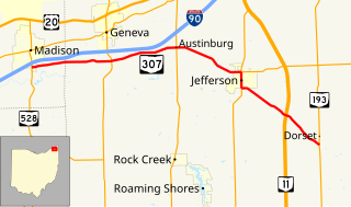
State Route 307 (SR 307) is an east–west state highway in the northeastern portion of the U.S. state of Ohio. Its western terminus is at State Route 528 on the southern boundary of Madison, and its eastern terminus is at State Route 193 nearly 7 miles (11 km) southeast of Jefferson.

State Route 97 (SR 97) is a 34.57-mile (55.64 km) state route that runs between Galion and south of Loudonville in the US state of Ohio. Most of the route is a rural two-lane highway and passes through woodland, farmland and residential properties. For some of its path, SR 97 runs near the Clear Fork Mohican River.

State Route 528 (SR 528) is north–south state highway in the northeastern portion of the U.S. state of Ohio. The southern terminus is at an intersection with U.S. Route 422 (US 422) and SR 88 in the village of Parkman, about 6½ miles south of Middlefield, and its northern terminus is at U.S. Route 20 about 2 miles (3.2 km) north of Madison. The entire highway is a two-lane highway, that passes through woodland and farmland. SR 528 was commissioned in the mid-1930s on the same route. The highway was extended in 1940, to US 20, replacing another state route. In the mid-1960s the route was extended south to US 422.

State Route 669 (SR 669) is an east–west state highway in Perry and Morgan Counties in the US state of Ohio. The western terminus of SR 669 is at an intersection with SR 13, southeast of Somerset. The eastern terminus of SR 669 at an intersection with SR 37 and SR 78. Most of the route is a rural two-lane highway and passes through woodland, farmland, and residential properties. For some of its path, SR 669 runs generally parallel to the west of Muskingum River.
Interstate 75 (I-75) runs from Cincinnati to Toledo by way of Dayton in the U.S. state of Ohio. The highway enters the state running concurrently with I-71 from Kentucky on the Brent Spence Bridge over the Ohio River and into the Bluegrass region. I-75 continues north into the Miami Valley and then passes through the Great Black Swamp before crossing into Michigan.
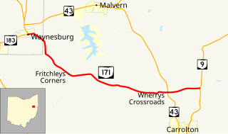
State Route 171 is a west–east state highway located in northeastern Ohio. The highway's western terminus is at a signalized intersection with SR 183 in Waynesburg. The eastern terminus of SR 171 is at SR 9 approximately two miles (3.2 km) north of Carrollton.
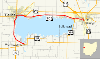
State Route 703 (SR 703) is a state highway in western Ohio. Its western terminus is in Montezuma at SR 219, and its eastern terminus is in St. Mary's at an intersection with SR 29, SR 66, and the southern terminus of SR 116 in St. Mary's. The route is mainly an east–west highway along the shores of Grand Lake St. Marys, although the section between Celina and Montezuma travels in a more north-south fashion.
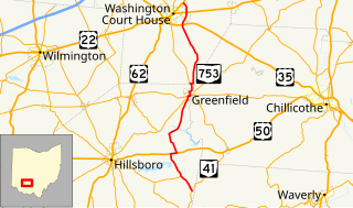
State Route 753 is a state highway in Ohio. The route is 35.35 miles (56.89 km) long and is located in eastern Highland County and southeastern Fayette County. The route's southern terminus is at an intersection with SR 41 in Brush Creek Township and its northern terminus is at an intersection with U.S. Route 62 and SR 3 on the border of Washington Court House and Union Township.