
The Battle of Okinawa, codenamed Operation Iceberg, was a major battle of the Pacific War fought on the island of Okinawa by United States Army (USA) and United States Marine Corps (USMC) forces against the Imperial Japanese Army (IJA). The initial invasion of Okinawa on 1 April 1945 was the largest amphibious assault in the Pacific Theater of World War II. The Kerama Islands surrounding Okinawa were preemptively captured on 26 March, (L-6) by the 77th Infantry Division. The 82-day battle lasted from 1 April until 22 June 1945. After a long campaign of island hopping, the Allies were planning to use Kadena Air Base on the large island of Okinawa as a base for Operation Downfall, the planned invasion of the Japanese home islands, 340 mi (550 km) away.

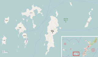
Okinawa Prefecture is a prefecture of Japan. Okinawa Prefecture is the southernmost and westernmost prefecture of Japan, has a population of 1,457,162 and has a geographic area of 2,281 km2.

Ie is a village located in Kunigami District, Okinawa Prefecture, Japan. The village lies on the island of Iejima.

Yomitan is a village located in Nakagami District, Okinawa Prefecture, Japan.

Zamami is a village located in Shimajiri District, Okinawa Prefecture, Japan. The village consists of more than 20 islands approximately 40 kilometres (25 mi) west of the prefectural capital of Naha. As of February 2013 the village had a population of 913 and a population density of 55.20 persons per km². The total area of the village of Zamami is 16.74 square kilometres (6.46 sq mi).
This article is about the history of the Ryukyu Islands southwest of the main islands of Japan.

The Ryukyu Kingdom was a kingdom in the Ryukyu Islands from 1429 to 1879. It was ruled as a tributary state of imperial China by the Ryukyuan monarchy, who unified Okinawa Island to end the Sanzan period, and extended the kingdom to the Amami Islands and Sakishima Islands. The Ryukyu Kingdom played a central role in the maritime trade networks of medieval East Asia and Southeast Asia despite its small size. The Ryukyu Kingdom became a vassal state of the Satsuma Domain of Japan after the invasion of Ryukyu in 1609 but retained de jure independence until it was transformed into the Ryukyu Domain by the Empire of Japan in 1872. The Ryukyu Kingdom was formally annexed and dissolved by Japan in 1879 to form Okinawa Prefecture, and the Ryukyuan monarchy was integrated into the new Japanese nobility.
The Kerama Islands are an island group 32 kilometres (20 mi) southwest of Okinawa Island in Japan. Historically, the islands were part of the Ryukyu Kingdom, and for some 600 years, islanders were employed as navigators on the kingdom’s trading vessels to China.

Iejima, previously romanized in English as Ie Shima, is an island in Okinawa Prefecture, Japan, lying a few kilometers off the Motobu Peninsula on Okinawa Island. The island measures 20 kilometres (12 mi) in circumference and covers 23 square kilometres (8.9 sq mi). As of December 2012 the island had a population of 4,610. Ie Village, which covers the entire island, has a ferry connection with the town of Motobu on Okinawa Island.
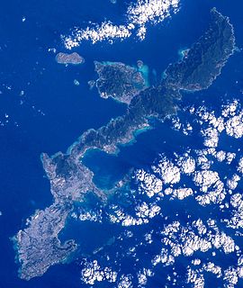
Okinawa Island is the largest of the Okinawa Islands and the Ryukyu (Nansei) Islands of Japan in the Kyushu region. It is the smallest and least populated of the five main islands of Japan. The island is approximately 106 kilometres (66 mi) long, an average 11 kilometres (7 mi) wide, and has an area of 1,206.98 square kilometers (466.02 sq mi). It is roughly 640 kilometres (400 mi) south of the main island of Kyushu and the rest of Japan. It is 500 km (300 mi) north of Taiwan. The total population of Okinawa Island is 1,384,762. The Greater Naha area has roughly 800,000 residents, while the city itself has about 320,000 people. Naha is the seat of Okinawa Prefecture on the southwestern part of Okinawa Island. Okinawa has a humid subtropical climate.

The 6th Marine Division was a United States Marine Corps World War II infantry division formed in September 1944. During the invasion of Okinawa it saw combat at Yae-Take and Sugar Loaf Hill and was awarded a Presidential Unit Citation. The 6th Division had also prepared for the invasion of Japan before the war ended. After the war it served in Tsingtao, China, where the division was disbanded on April 1, 1946, being the only Marine division to be formed and disbanded overseas and never set foot in the United States.
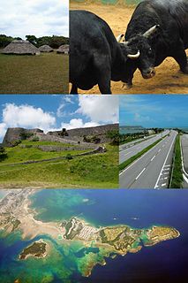
Uruma is a city located in Okinawa Prefecture, Japan. The modern city of Uruma was established on April 1, 2005, when the cities of Gushikawa and Ishikawa were merged with the towns of Katsuren and Yonashiro. As of May 1, 2013, the city has an estimated population of 118,330 and a population density of 1,400 people per km2. The total area is 86.00 km2. The city covers part of the east coast of the south of Okinawa Island, the Katsuren Peninsula, and the eight Yokatsu Islands. The Yokatsu Islands include numerous sites important to the Ryukyuan religion, and the city as a whole has numerous historical sites, including: Katsuren Castle, Agena Castle, and Iha Castle and the Iha Shell Mound. It is home to the largest venue for Okinawan bullfighting. The Mid-Sea Road, which crosses the ocean and connects the Yokatsu Islands to the main island of Okinawa, is now a symbol of Uruma.
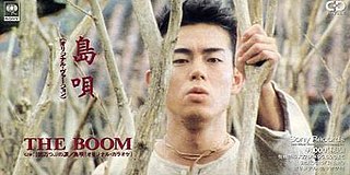
"Shima Uta" is a 1992 song by the Japanese band The Boom. It was written by the lead singer, Kazufumi Miyazawa, based on his impressions from visiting Okinawa for a photo shoot. It is the band's best selling song, well known throughout Japan and Argentina, and one of the most widely known songs associated with Okinawa although the band members are all from Yamanashi Prefecture. The song uses a mix of modern pop and rock styles as well as min'yō. Okinawan musical instruments and Okinawan vocabulary have been incorporated into the song.
National Route 58 is a Japanese national highway connecting the capital cities Kagoshima and Naha of Kagoshima Prefecture and Okinawa Prefecture, respectively. With a total length of 884.4 kilometers (549.5 mi), it is the longest national highway in Japan, though it measures only 245.2 kilometers (152.4 mi) on land. The highway begins at an intersection with National Routes 3 and 10 in Kagoshima. From Kagoshima, it travels southwest along the first island chain that divides the Pacific Ocean from the East China Sea. From the north to the south, it has sections on the islands of Tanegashima, Amami Ōshima, and finally, Okinawa. On Okinawa it ends at an intersection with National Routes 330, 331, and 390 in Naha.
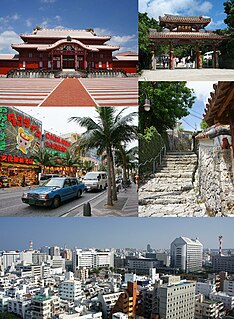
Naha is the capital city of Okinawa Prefecture, the southernmost prefecture of Japan. As of 1 June 2019, the city has an estimated population of 317,405 and a population density of 7,939 persons per km2. The total area is 39.98 km2 (15.44 sq mi)
Intelligence and the Japanese Civilian was a 1945 film produced by the US Marine Corps, to instruct Marines on how they should handle the civilian population of Japan during the post-war occupation.
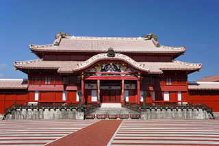
Shuri is a district of the city of Naha, Okinawa. It was formerly a separate city in and of itself, and the royal capital of the Ryūkyū Kingdom. A number of famous historical sites are located in Shuri, including Shuri Castle, the Shureimon gate, Sunuhyan-utaki, and royal mausoleum Tamaudun, all of which are designated World Heritage Sites by UNESCO.

The military of the Ryukyu Kingdom defended the kingdom from 1429 until 1879. It had roots in the late army of Chūzan, which became the Ryukyu Kingdom under the leadership of King Shō Hashi. The Ryukyuan military operated throughout the Ryukyu Islands, the East China Sea, and elsewhere that Ryukyuan ships went. Ryukyu primarily fought with other Ryukyuan kingdoms and chiefdoms, but also Japanese samurai from Satsuma Domain and pirates. Soldiers were stationed aboard ships and Ryukyuan fortifications. The Ryukyuan military declined after the 17th century.
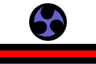
The flag of Ryukyu is a number of flags that represent the Ryukyu Kingdom, the Ryukyu Islands, and the Ryukyuan people.
Chikako Yamashiro is a Japanese filmmaker and video artist. Her works in photography, video and performance create visual investigations into the history, politics and culture of her homeland Okinawa. Particularly salient are themes related to the terrible civilian casualties incurred in Okinawa during World War II and the on-going troubles and hardships caused by the U.S. military presence in Okinawa. Since 2019 she is Associate Professor at the Tokyo University of the Arts.