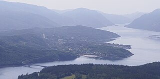
Terråk is the administrative centre of the municipality of Bindal in Nordland country, Norway. The village is located in the eastern part of the municipality, along the shore of the Sørfjorden arm of the Bindalsfjorden. The nearby Vassås Bridge connects Terråk to the village of Vassås just to the north.

Saglivatnet is a lake on the border of Trøndelag and Nordland counties in Norway. The 2.16-square-kilometre (0.83 sq mi) lake lies on the border of the municipalities of Nærøy and Bindal. The water flows out to the north into the river Saglielva which flows into the Sørfjorden, an arm off the main Bindalsfjorden.
Oldervika may refer to the following locations:

Vågaholmen is the administrative centre of the municipality of Rødøy in Nordland county, Norway. The village is located along the Tjongsfjorden, just west of the village of Tjong.
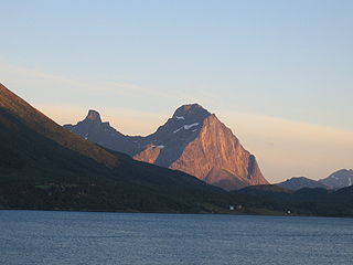
Blokktinden or Blokktind is a mountain in the municipality of Rødøy in Nordland county, Norway. It is located on the southern side of Tjongsfjorden, across from the village of Tjong. The summit has a good view of the Svartisen glacier and the coastal islands.
Ågskardet is a village in the municipality of Meløy in Nordland county, Norway. It is located on the southern side of the Holandsfjorden, about 3.5 kilometres (2.2 mi) north of the village of Tjong. There were 127 inhabitants in 2008.
Sørfjorden or Sørfjord is the name of several fjords on the coast of Norway.
Bindalsfjorden is a fjord in the southern part of Nordland county, Norway. The fjord is mostly located in the municipality of Bindal with a small part in neighboring Sømna municipality. The 71-kilometre (44 mi) long fjord begins near the villages of Terråk and Vassås where the Sørfjorden and Tosenfjorden join together. It then flows northwest past Bindalseidet and then southwest past the village of Holm before the mouth of the fjord by the island of Austra.

Storselsøya is an island in Nordland county, Norway. The island is divided between two municipalities: Rødøy in the north and Lurøy in the south. The island of Nesøya lies to the west, the island of Lurøya lies to the south, and the mainland village of Tonnes lies to the east.

Rødøya is an island in the municipality of Rødøy in Nordland county, Norway. The 8.5-square-kilometre (3.3 sq mi) island is located just west of the mouth of the Tjongsfjorden, north of the island of Gjerdøya, and west of the mainland. There are ferry connections from the village of Rødøy to the village of Jektvika on the mainland and to the nearby island of Gjerdøya. Rødøy Church is located in the village of Rødøy on the south side of the island. The island had 150 residents in 2017.

Melfjorden is a fjord in the municipality of Rødøy in Nordland county, Norway. It is located on the Arctic Circle. The 33-kilometre (21 mi) long fjord goes from the village of Melfjordbotn in the east to its mouth in the Rødøyfjorden near the island of Rangsundøya. There are two fjord arms that branch off the main fjord: Nordfjorden flows to the north into the Saltfjellet–Svartisen National Park and Sørfjorden to the south past the villages of Sørfjorden and Kilboghavn.
Melfjordbotn or Melfjorden is a village in Rødøy Municipality in Nordland county, Norway. The village is located at the eastern end of the Melfjorden, southwest of the Svartisen glacier. The Saltfjellet–Svartisen National Park lies about 7 kilometres (4.3 mi) north of the village.
Rødøy Church is a parish church of the Church of Norway in Rødøy Municipality in Nordland county, Norway. It is located on the island of Rødøya. It is one of the churches in the Rødøy parish which is part of the Nord-Helgeland prosti (deanery) in the Diocese of Sør-Hålogaland. The white, wooden church was built in a octagonal style in 1885 by the architect A. Grenstad. The church seats about 700 people.
Tjongsfjorden Church is a parish church of the Church of Norway in Rødøy Municipality in Nordland county, Norway. It is located in the village of Tjong on the mainland in the northern part of the municipality. It is one of the churches in the Rødøy parish which is part of the Nord-Helgeland prosti (deanery) in the Diocese of Sør-Hålogaland. The white, wooden church was built in a long church style in 1962 by the architect Per Myrvold. The church seats about 280 people.
Sørfjorden Church is a parish church of the Church of Norway in Rødøy Municipality in Nordland county, Norway. It is located in the village of Sørfjorden on the mainland in the southern part of the municipality. It is one of the churches in the Rødøy parish which is part of the Nord-Helgeland prosti (deanery) in the Diocese of Sør-Hålogaland. The white, wooden church was built in a long church style in 1916 by the architect O.M. Olsen. The church seats about 230 people.
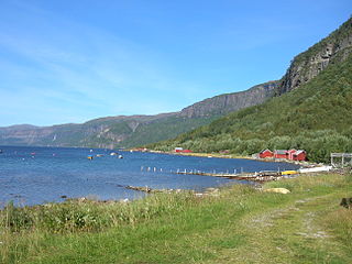
Sørfjorden is a village in the municipality of Rødøy in Nordland county, Norway. The village is located on the eastern shore of the Sørfjorden, just south of Oldervika. It is the location of Sørfjorden Church. There is no road connection to the rest of Norway, even though it is located on the mainland. The only access is by ferry to Kilboghamn and Jektvika.
Tjong or Tjongsfjord is a village in the municipality of Rødøy in Nordland county, Norway. The village is located along the Tjongsfjorden, east of the municipal center of Vågaholmen. The local church, Tjongsfjorden Church, serves all of northeastern Rødøy. The village of Ågskardet in neighboring Meløy Municipality lies about 3.5 kilometres (2.2 mi) to the north.
Sørfjorden Chapel is a chapel of the Church of Norway in Gildeskål Municipality in Nordland county, Norway. It is located in the village of Sørfinnset. It is an annex chapel in the Gildeskål parish which is part of the Bodø domprosti (deanery) in the Diocese of Sør-Hålogaland, although the chapel building is not owned by the parish, it is privately owned by the local residents of the Sørfjorden farms. The white, wooden chapel was built in a long church style in 1927. The chapel seats about 300 people. The church is used for worship services about four times each year.
Sørfinnset is a village in the municipality of Gildeskål in Nordland county, Norway. It is located on the mainland, south of the vilalge of Inndyr and east of the village of Storvika. Norwegian County Road 17 passes by 2 kilometres (1.2 mi) south of the village. Sørfjorden Chapel is located in the village.