Related Research Articles

Bluffton is a city in Otter Tail County, Minnesota, United States, along the Leaf River. The population was 207 at the 2010 census.
Reedy Island is a small island in the middle of the channel of the Delaware River near its mouth on Delaware Bay in the U.S. state of Delaware. It is located approximately one mile (1.6 km) east of Port Penn, Delaware and five miles (8.0 km) southwest of Salem, New Jersey.

The Río Negro is the most important river in Uruguay. It originates in the southern highlands of Brazil, just east of Bagé, and flows west across the entire width of Uruguay to the Uruguay River. The course of the Río Negro across Uruguay effectively divides the south of the country from the north. The Río Negro's principals tributaries are Yí River and Tacuarembó River.

Cerro Largo Department is a department of Uruguay. Its capital is Melo. It is located in the east of the country, bordering Brazil to its northeast with Yaguaron River as the natural border, Treinta y Tres Department to its south, Durazno Department to its west and the departments of Tacuarembó and Rivera to its northwest with Negro River as its natural border with them.

The Oka is a river in Siberia, left tributary of the Angara River. It originates in the Sayan Mountains in western Buryatia and flows through Irkutsk Oblast. It flows for 630 km (391 mi), into the Bratsk reservoir.

The Holland River is a river in Ontario, Canada, that drains the Holland River watershed into Cook's Bay, the southern extremity of Lake Simcoe. It is named after Captain Samuel (Johannes) Holland, (1729–1801), Dutch-born first Surveyor General of British North America. The river flows generally north, and its headwaters lie in the Oak Ridges Moraine. The Holland River watershed is approximately 600 square kilometres (230 sq mi), spanning an area that includes New Tecumseth, King Township, Newmarket, Aurora, East Gwillimbury, and Whitchurch-Stouffville.
Babine Lake Marine Provincial Park is a provincial park in British Columbia, Canada. The park was established by Order-in-Council in 1993, comprising two sites at Pendleton Bay totalling 36.9 hectares. Another was established in the same year at Smithers Landing, comprising approximately 157.8 hectares. Three more sites were added in 2001, Hook (Deep) Bay, Pierre Creek, Pinkut Creek and Sandpoint. All sites combined comprise approximately 492 hectares.
Moortown is a rural area in the north east of County Tyrone, Northern Ireland. It lies on the western shores of Lough Neagh, beside Ballinderry and Ardboe. It is relatively close to the towns of Cookstown, Magherafelt and Dungannon. It is in Cookstown District Council area. Places of interest include Kinturk Cultural Centre, Coyles Cottage, the air-drome, the Battery Harbour and the Ardboe High Cross.

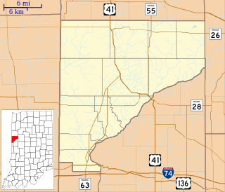
Kickapoo was a small town in Warren Township, Warren County, in the U.S. state of Indiana.

Pai Pedro is a municipality in the northeast of the Brazilian state of Minas Gerais. As of 2007 the population was 5,979 in a total area of 785 km2 (303 sq mi). The elevation is 520 meters (1,710 ft). It became a municipality in 1997. The postal code (CEP) is 39517-000.

Frays River is a semi-canalised short river in England that branches off the River Colne at Uxbridge Moor and rejoins it at West Drayton. The river is believed to be a man-made diversion of waters from the River Colne to feed watermills around Uxbridge. The name is originates from John Fray who owned Cowley Hall beside the river in the fifteenth century. Other names for the river are the Uxbridge and Cowley Mill Stream, the Cowley Stream or the Colham Mill Stream. In the 17th century the river powered five mills. Drayton Mill at West Drayton was mentioned in Domesday Book and was used for flour milling, paper-making and the manufacture of millboard. It ceased operation in about 1923.
Gile is a village in the administrative district of Gmina Bartoszyce, within Bartoszyce County, Warmian-Masurian Voivodeship, in northern Poland, close to the border with the Kaliningrad Oblast of Russia.
The Arroyo de la India Muerta is a river of Uruguay.
Bimberamala River, a perennial river of the Clyde River catchment, is located in the Southern Tablelands and the upper ranges of the South Coast regions of New South Wales, Australia.

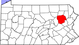
Waterton is an unincorporated community in Huntington Township, Luzerne County, Pennsylvania, United States. It lies between the boroughs of New Columbus and Shickshinny.

Kirklionys is a village in Varėna district municipality, in Alytus County, in southeastern Lithuania. According to the 2001 census, the village has a population of 3 people.

This is a list of the extreme points of Uruguay, the points that are farther north, south, east or west than any other location, and the highest and lowest points. It is also notable that Uruguay's northernmost point is farther south than the northernmost point of any other nation.
Fillmore is a populated place in Bossier Parish, Louisiana, United States, named after U.S. President Millard Fillmore.
Punta Gorda is a landform in Colonia Department, Uruguay.
References
- Rand McNally, The New International Atlas, 1993.
- GEOnet Names Server
Coordinates: 33°13′59″S54°30′55″W / 33.23306°S 54.51528°W

A geographic coordinate system is a coordinate system that enables every location on Earth to be specified by a set of numbers, letters or symbols. The coordinates are often chosen such that one of the numbers represents a vertical position and two or three of the numbers represent a horizontal position; alternatively, a geographic position may be expressed in a combined three-dimensional Cartesian vector. A common choice of coordinates is latitude, longitude and elevation. To specify a location on a plane requires a map projection.
| This article related to a river in Uruguay is a stub. You can help Wikipedia by expanding it. |