Zeta is a river in Montenegro. Its source is under the mountain Vojnik, and flows eastwards for 65 km (40 mi) until it flows into the river Morača just north of Podgorica. Its drainage basin area is 1,597 km2 (617 sq mi).

Mount Kyllini or Mount Cyllene, is a mountain on the Peloponnese in Greece famous for its association with the god Hermes. It rises to 2,376 m (7,795 ft) above sea level, making it the second highest point on the peninsula. It is located near the border between the historic regions of Arcadia and Achaea—in the northeast of Arcadia, and entirely within modern Corinthia. It is located west of Corinth, northwest of Stymfalia, north of Tripoli, and south of Derveni.

Kalavryta is a town and a municipality in the mountainous east-central part of the regional unit of Achaea, Greece. The town is located on the right bank of the river Vouraikos, 24 kilometres south of Aigio, 40 km southeast of Patras and 62 km northwest of Tripoli. Notable mountains in the municipality are Mount Erymanthos in the west and Aroania or Chelmos in the southeast. Kalavryta is the southern terminus of the Diakopto-Kalavryta rack railway, built by Italian engineers between 1885 and 1895.

The Ladon is a river in the Peloponnese peninsula of Greece. It features in Greek mythology. It is a tributary to the river Alfeios, which empties into the Ionian Sea. It is 70 km (43 mi) long.

Aroania, also known as Helmos or Chelmos, is a mountain range in Achaea, Peloponnese, Greece. At 2,355 m elevation, Aroania is the third highest mountain of the Peloponnese, after Taygetus and Kyllini, and the highest in Achaea. The largest town near the mountain is Kalavryta. The municipal unit Aroania took its name from the mountain.

The Pineiós is a river in Thessaly, Greece. The river is named after the god Peneus. During the later Middle Ages, it was also known as the Salambrias or Salabrias (Σαλα[μ]βριάς).

Peristera is a small mountain village and a community, part of the municipal unit of Akrata, Achaea, Greece. It is located at the foot of the mountain Chelmos or Aroania, at an altitude of about 1,200 m. Peristera is connected by road north to Akrata. Mesorrougi is 1 km to the south, and Akrata is 16 km to the northeast. The community includes the villages Agridi and Chalkianika.

Arcadia was a region in the central Peloponnese. It took its name from the mythological character Arcas and in Greek mythology, it was the home of the god Pan. In European Renaissance arts, Arcadia was celebrated as an unspoiled, harmonious wilderness; as such, it was referenced in popular culture.
Krios is a stream in the municipal unit of Aigeira, in Achaea, southern Greece. It is 20.3 km (12.6 mi) long. Its source is on mount Chelmos, near the village Perithori. It flows near the ancient city of Felloi and the villages Sinevro, Oasi and the Mycenaean acropolis of ancient Aigeira. The stream empties into the Gulf of Corinth near Aigeira.

Erymanthos is a mountain range in the southern part of Achaea and the northeastern part of Elis. With an elevation of 2,224 meters, it is the fourth-tallest mountain in the Peloponnese peninsula. The summit is located on the boundary of Achaea and Elis. Historically, Mount Erymanthos was part of northwestern Arcadia, where it was the second-tallest mountain range. The northern portion belonged to the historic Achaea.

Erymanthos is a river in the western part of the Peloponnese in Greece. Its source is on the southern slope of the Mount Erymanthos, near the village Agrampela, Achaea. It flows towards the south through a rocky landscape and receives several small tributaries. The river flows into an area rich in pine trees and passes several small mountain villages including Tripotama. Beyond Tripotama it forms the border between Elis and Arcadia. It flows east of the Foloi oak forest. The river empties into the Alfeios 5 km west of the Ladon (river) confluence, near the village Tripotamia.

Krathis is a river in the eastern part of Achaea, southern Greece. The river flows through the municipal unit of Akrata. It is 32.6 km (20.3 mi) long.
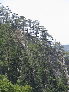
The Pindus Mountains mixed forests constitute a terrestrial ecoregion of Europe according to both the WWF and Digital Map of European Ecological Regions by the European Environment Agency. It belongs to the biome of Mediterranean forests, woodlands, and scrub, and to the Palearctic ecozone.

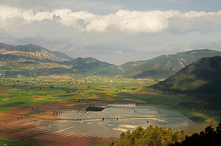
Pheneus or Pheneos was a town in the northeast of ancient Arcadia. Its territory, called Pheniatis, was bounded on the north by that of the Achaean towns of Aegeira and Pellene, east by the Stymphalia, west by the Cleitoria, and south by the Caphyatis and Orchomenia. This territory is shut in on every side by lofty mountains, offshoots of Mount Cyllene and the Aroanian chain; and it is about 7 miles in length and the same in breadth. Two streams descend from the northern mountains, and unite their waters about the middle of the valley; the united river bore in ancient times the name of Olbius and Aroanius. There is no opening through the mountains on the south; but the waters of the united river are carried off by subterranean channels (katavóthra) in the limestone rocks, and, after flowing underground, reappear as the sources of the river Ladon. In order to convey the waters of this river in a single channel to the katavóthra, the inhabitants at an early period constructed a canal, 50 stadia in length, and 30 feet in breadth. This great work, which was attributed to Heracles, had become useless in the time of Pausanias, and the river had resumed its ancient and irregular course; but traces of the canal of Heracles are still visible, and one bank of it was a conspicuous object in the valley when it was visited by William Martin Leake in 1806. The canal of Heracles, however, could not protect the valley from the danger to which it was exposed, in consequence of the katavóthra becoming obstructed, and the river finding no outlet for its waters. The Pheneatae related that their city was once destroyed by such an inundation, and in proof of it they pointed out upon the mountains the marks of the height to which the water was said to have ascended. Pausanias evidently refers to the yellow border which is still visible upon the mountains and around the plain: but in consequence of the great height of this line upon the rocks, it is difficult to believe it to be the mark of the ancient depth of water in the plain, and it is more probably caused by evaporation; the lower parts of the rock being constantly moistened, while the upper are in a state of comparative dryness, thus producing a difference of colour in process of time. It is, however, certain that the Pheneatic plain has been exposed more than once to such inundations. Pliny the Elder says that the calamity had occurred five times; and Eratosthenes related a memorable instance of such an inundation through the obstruction of the katavóthra, when, after they were again opened, the water rushing into the Ladon and the Alpheius overflowed the banks of those rivers at Olympia. The account of Eratosthenes has been confirmed by a similar occurrence in modern times. In 1821 the katavóthra became obstructed, and the water continued to rise in the plain till it had destroyed 7 to 8 square miles of cultivated country. Such was its condition till 1832, when the subterraneous channels again opened, the Ladon and Alpheius overflowed, and the plain of Olympia was inundated. Other ancient writers allude to the katavóthra and subterraneous course of the river of Pheneus.

Planitero is a mountain village in the municipal unit of Kleitoria, Achaea, Greece. It is situated in the southwestern part of the Chelmos (Aroania) mountains. Its population is 197 people. Its elevation is 700 m. Planiteri is 1.5 km north of Armpounas, 6 km northeast of Kleitoria and 12 km southeast of Kalavryta. The source of the river
Aroanios is near Planitero.

Lake Doxa is an artificial lake in western Corinthia, Greece. It is situated at an elevation of 900 m, in the municipal unit Feneos, near the village Archaia Feneos. Construction was completed in the late 1990s. It is fed and drained by the small river Doxa (Δόξα), which empties into the plain of Feneos. In the heart of the lake on a small peninsula features a small church of Agios Fanourios. The Saint George Monastery in Feneos was relocated to higher ground, north of the lake. The lake is surrounded by pine forests.
The Feneos Executions is the name given to a series of killings committed by the Greek People's Liberation Army (ELAS) resistance group, and especially by its secret police OPLA, in the Feneos area of Corinthia, Greece, during the very first stages of the Greek Civil War, while the country was still occupied by the Axis Powers.
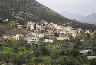
Marathos is a mountain village in the municipality of Malevizi, in the Crete region of Greece. It is about 20 kilometres west of Heraklion. The Marathianos River runs nearby and flows down to Fodele. The village relies mainly on agriculture, livestock and bee keeping.