
Namibia, officially the Republic of Namibia, is a country in Southern Africa. Its western border is the Atlantic Ocean. It shares land borders with Zambia and Angola to the north, Botswana to the east and South Africa to the south and east. Although it does not border Zimbabwe, less than 200 metres of the Botswanan right bank of the Zambezi River separates the two countries. Its capital and largest city is Windhoek.

At 824,292 km2 (318,261 sq mi), Namibia is the world's thirty-fourth largest country. After Mongolia, Namibia is the second least densely populated country in the world. Namibia got its name from the Namib desert that stretches along the coast of the Atlantic. It is also known for its wildlife.

The Zambezi Region is one of the 14 regions of Namibia. It is located in the north-eastern part of the country. It is largely concurrent with the major Zambezi River after which it was named. The region has eight constituencies and its capital is the town of Katima Mulilo. The self-governed village Bukalo is also situated in this region. The Zambezi Region had a population of 90,596 in 2011. As of 2020, it had 47,884 registered voters.
In South Africa, the terms township and location usually refer to the often underdeveloped racially segregated urban areas that, from the late 19th century until the end of apartheid, were reserved for non-whites, namely Black Africans, Coloureds and Indians. Townships were usually built on the periphery of towns and cities. The term township also has a distinct legal meaning in South Africa's system of land title, which carries no racial connotations.

Omusati is one of the fourteen regions of Namibia, its capital is Outapi. The towns of Okahao, Oshikuku and Ruacana as well as the self-governed village Tsandi are situated in this region. As of 2020, Omusati had 148,834 registered voters.

Ohangwena is one of the fourteen regions of Namibia, its capital is Eenhana. Major settlements in the region are the towns Eenhana and Helao Nafidi aa well as the self-governed village of Okongo. As of 2020, Ohangwena had 150,724 registered voters.

Colophospermum mopane, commonly called mopane, mopani, balsam tree, butterfly tree, or turpentine tree, is a tree in the legume family (Fabaceae), that grows in hot, dry, low-lying areas, 200 to 1,150 metres in elevation, in the far northern parts of Southern Africa. The tree only occurs in Africa and is the only species in genus Colophospermum. Its distinctive butterfly-shaped (bifoliate) leaf and thin seed pod make it easy to identify. In terms of human use it is, together with camel thorn and leadwood, one of the three regionally important firewood trees.
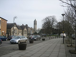
Dunboyne is a town in Meath, Ireland, 15 km north-west of Dublin city centre. It is a commuter town for Dublin. In the 20 years between the 1996 and 2016 censuses, the population of Dunboyne more than doubled from 3,080 to 7,272 inhabitants. As per the 2022 census, the population decreased slightly to 7,155.

Gonimbrasia belina is a species of emperor moth which is native to the warmer parts of southern Africa. Its large edible caterpillar, known as the mopane worm, madora, amacimbi “pigeon moth” or masontja, feeds primarily but not exclusively on mopane tree leaves. Mopane worms are an important source of protein for many in the region. The species was first described by John O. Westwood in 1849.
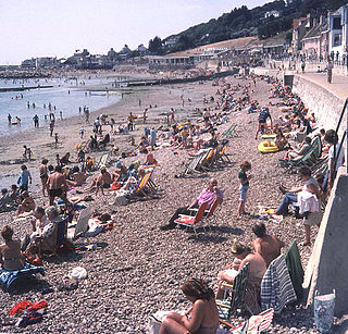
A period of unusually hot summer weather occurred in the British Isles during the summer of 1976. At the same time, there was a severe drought on the islands of Great Britain and Ireland. It was one of the driest, sunniest and warmest summers (June/July/August) in the 20th century, although the summer of 1995 is now regarded as the driest. Only a few places registered more than half their average summer rainfall. In the Central England temperature record, it was the warmest summer in the series until being surpassed in the 21st century. It was the warmest summer in the Aberdeen area since at least 1864, and the driest summer since 1868 in Glasgow.

Oshakati is a town in northern Namibia. It is the regional capital of the Oshana Region and one of Namibia's largest cities both by population and as an economic center.
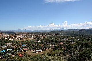
Outapi wa Nakafingo na Temba, also Outapi or Uutapi and Ombalantu, is a town in northern Namibia near the border with Angola, situated 90 km (56 mi) northwest of Oshakati. It is the capital of the Omusati region and the district capital of the Outapi electoral constituency. The language spoken there is Oshiwambo.
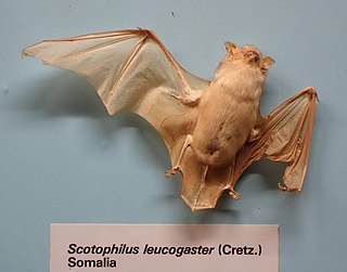
The white-bellied yellow bat or white-bellied house bat, is a species of vesper bat in the genus Scotophilus, the house bats. It can be found in Angola, Benin, Botswana, Burkina Faso, Cameroon, Central African Republic, Chad, Ivory Coast, Gambia, Ghana, Guinea, Guinea-Bissau, Kenya, Mali, Mauritania, Namibia, Niger, Nigeria, Senegal, Sierra Leone, Sudan, Togo, Uganda, and Zambia. It is found in dry and moist savanna and open woodland. It is a common species with a very wide range, and the International Union for Conservation of Nature has assessed its conservation status as being of "least concern".
The 2008 Namibia floods took place in early February 2008, a rapid onset of heavy rains triggered floods in northern Namibia, leading to one of its worst floods in 50 years. The floods had killed 42 people by early March and an estimated 65,000 people were affected, primarily in the regions of Omusati, Oshikoto, Oshana, Ohangwena and Caprivi. 40,000 people were assisted by the Namibian Red Cross with 4,600 in relocation camps. Over-crowding and insanitary conditions caused health concerns in relocation camps and an outbreak of cholera was announced in March. On 14 March, the United Nations Office for Outer Space Affairs triggered the International Charter for "Space and Major Disasters". Staple crops were devastated and 52,000 people from flood-affected areas were considered in need of immediate of assistance to cover their basic food needs. Deputy Prime Minister Libertine Amathila declared that the government would spend 65 million Namibian dollars to assist the displaced. Long-term impacts included damage to farmland, housing, schools, roads and infrastructure across the region. The floods reduced the resilience of the population who were left vulnerable to further flooding which occurred in 2009.

The 2009 Angola, Namibia and Zambia floods was a natural disaster which began in early March 2009 and resulted in the deaths of at least 131 people and otherwise affected around 445,000 people. The floods affected seven regions of Namibia, three provinces of Zambia, two regions of Angola and part of Botswana. The floodwaters damaged buildings and infrastructure and displaced at least 300,000 people. A state of emergency was declared in northern Namibia and there were fears that a disease epidemic would ensue. The Red Cross agencies and governments of the two countries responded to the disaster, and aid was distributed be the World Health Organization.
Okahao is a town in the Omusati Region of northern Namibia and the district capital of the Okahao electoral constituency. It is situated in the Ongandjera tribal area 73 kilometres (45 mi) west of Oshakati on the main road MR123. It is a former mission station of the Finnish Missionary Society.

Elim Constituency is an electoral constituency in the Omusati Region of Namibia. It had 15,210 inhabitants in 2004 and 7,883 registered voters in 2020. Its district capital is the settlement of Elim.

Mudumu is a National Park in Caprivi Region in north-eastern Namibia. The park was established in 1990. It covers an area of 737 square kilometres (285 sq mi). The Kwando River forms the western border with Botswana. Various communal area conservancies and community forests surround Mudumu National Park.