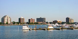
Sarnia is a city in Southwestern Ontario, Canada, with a 2016 population of 71,594. It is the largest city on Lake Huron and in Lambton County. Sarnia is located on the eastern bank of the junction between the Upper and Lower Great Lakes where Lake Huron flows into the St. Clair River, which forms the Canada–United States border, directly across from Port Huron, Michigan. The site's natural harbour first attracted the French explorer La Salle. He named the site "The Rapids" on 23 August 1679, when he had horses and men pull his 45-ton barque Le Griffon north against the nearly four-knot current of the St. Clair River.

Lambton County is a county in Southwestern Ontario, Canada. It is bordered on the north by Lake Huron, which is drained by the St. Clair River, the county's western border and part of the Canada-United States border. To the south is Lake Saint Clair and Chatham-Kent, another county in Ontario. Lambton County's northeastern border follows the Ausable River and Parkhill Creek north until it reaches Lake Huron at the beach community of Grand Bend. The county seat is in the Town of Plympton-Wyoming.
Bothwell was a federal and provincial electoral district in the Canadian province of Ontario, which was represented in the House of Commons of Canada from 1867 to 1904 and in the Legislative Assembly of Ontario from 1867 to 1875. It is sometimes also considered one of Ontario's historic counties, as it was listed in some post-Confederation census records as a county of residence.

King's Highway 402, commonly referred to as Highway 402 and historically as the Blue Water Bridge Approach, is a 400-series highway in the Canadian province of Ontario that connects the Blue Water Bridge international crossing near Sarnia to Highway 401 in London. It is one of multiple trade links between Ontario and the Midwestern United States. It is four lanes for much of its length, though the approach to the Blue Water Bridge is six lanes.

Lambton—Kent—Middlesex is a federal electoral district in Ontario, Canada, that has been represented in the House of Commons of Canada since 1997.
Lambton East was a federal electoral district represented in the House of Commons of Canada from 1882 to 1935. It was located in the province of Ontario. This riding was created from Lambton riding.
Lambton West was a federal electoral district represented in the House of Commons of Canada from 1883 to 1968. It was located in the province of Ontario. This riding was created from parts of Lambton riding.
Lambton—Kent was a federal electoral district in Ontario, Canada, that was represented in the House of Commons of Canada from 1935 to 1979. This riding was created in 1933 from parts of Kent, Lambton East and Lambton West ridings.
Middlesex was a federal electoral district represented in the House of Commons of Canada from 1968 to 1979. It was located in the province of Ontario. This riding was created in 1966 from parts of Lambton West, Lambton—Kent, Middlesex West and Middlesex East ridings.
Lambton—Middlesex is a federal electoral district represented in the House of Commons of Canada from 1979 to 1997. It was located in the province of Ontario. This riding was created in 1976 from parts of Huron—Middlesex, Lambton—Kent, Middlesex—London—Lambton and Sarnia—Lambton ridings.
Perth—Middlesex was an electoral district in Ontario, Canada, that was represented in the House of Commons of Canada from 1997 to 2003 and in the Legislative Assembly of Ontario from 1999 to 2007.
Patricia A. "Pat" Davidson was a member of the House of Commons of Canada from 2006 until 2015 representing the riding of Sarnia—Lambton and is a member of the Conservative Party of Canada.
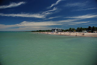
Lambton Shores is a municipality in Lambton County, Ontario, Canada, that is on the southern shores of Lake Huron.

Plympton–Wyoming is a town in the Canadian province of Ontario, located in Lambton County immediately east of Sarnia. It is the seat of the Lambton County Council.
The Lambton Kent District School Board is the school board responsible for public education in Lambton County and Kent County. Lambton and Kent Counties are made up of numerous small towns and communities situated in Southwestern Ontario, a geographic area surrounded by the Great Lakes. The board serves over 21,000 elementary and high school students. Surrounding towns and communities include Wheatley, Tilbury, Merlin, Blenheim, Chatham, Ridgetown, Thamesville, Dresden, Wallaceburg, Bothwell, Mooretown, Corunna, Sarnia, Brigden, Petrolia, Alvinston, Point Edward, Wyoming, Watford, Forest, Grand Bend, and Wyoming.
King's Highway 40, commonly referred to as Highway 40, is a provincially maintained highway in the southwestern portion of the Canadian province of Ontario. The 91.4-kilometre (56.8 mi) route links Chatham and Sarnia via Wallaceburg, following close to the St. Clair River. The southern terminus is at Highway 401 south of Chatham, while the northern terminus is at Highway 402 in Sarnia. The portion of Highway 40 between Highway 401 and north of Wallaceburg is within the municipality of Chatham-Kent, while the portion north of there is within Lambton County.

Brooke-Alvinston is a township municipality in the Canadian province of Ontario, located within Lambton County. It was formed on January 1, 2001, when the Township of Brooke was amalgamated with the Village of Alvinston.
King's Highway 22, commonly referred to as Highway 22, was a provincially maintained highway in the Canadian province of Ontario, located between Sarnia and London. Since 1998, the majority of the former route has been known as Middlesex County Road 22 and Lambton County Road 22. It began at Highway 7 and Highway 79 north of Watford and proceeded 46.0 kilometres (28.6 mi) east to Highway 4 in the north end of London. Between those two points, it passed through the small communities of Wisbeach, Dejong, Adelaide, Wrightmans Corners, Hickory Corner, Poplar Hill, Lobo, and Melrose. The highway was located within Lambton County, Middlesex County, and the city of London, and it followed the historic Egremont Road
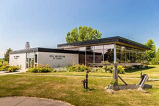
The Oil Museum of Canada, is a petroleum heritage museum in Oil Springs, Ontario, Canada. The museum is located on the site where James Miller Williams dug the first commercial oil well on the continent in 1858.