
Aleutians East Borough is a 2nd class borough in the U.S. state of Alaska. As of the 2020 census the borough's population was 3,420. The borough seat is Sand Point.

Kodiak Island Borough is a borough in the U.S. state of Alaska. At the 2020 census, the population was 13,101, down from 13,592 in 2010. The borough seat is Kodiak.

Cold Bay is a city in Aleutians East Borough, Alaska, United States. As of the 2010 census, the population was 108, but at the 2020 census this had reduced to 50.
King Cove is a city in Aleutians East Borough, Alaska, United States. As of the 2010 census, its population was 938, up from 792 in 2000, but at the 2020 census this had reduced to 757.

The Alaska Peninsula National Wildlife Refuge is a United States National Wildlife Refuge in southwestern Alaska whose use is regulated as an ecological-protection measure. It stretches along the southern coast of the Alaska Peninsula, between the Becharof National Wildlife Refuge on its east and the end of the peninsula at False Pass in the west. In between, however, it is broken into sections by lands of the Aniakchak National Monument and Izembek National Wildlife Refuge. The refuge is administered from offices in King Salmon, Alaska and was established to conserve Alaska Peninsula brown bears, caribou, moose, marine mammals, shorebirds, other migratory birds and fish, and to comply with treaty obligations.

The Kodiak National Wildlife Refuge is a United States National Wildlife Refuge in the Kodiak Archipelago in southwestern Alaska, United States.

The Alaska Peninsula is a peninsula extending about 497 mi (800 km) to the southwest from the mainland of Alaska and ending in the Aleutian Islands. The peninsula separates the Pacific Ocean from Bristol Bay, an arm of the Bering Sea.
The Saint Lazaria Wilderness or St. Lazaria Island is a nesting bird colony located twenty miles (32 km) west of Sitka, Alaska and is a part of the Gulf of Alaska unit of the Alaska Maritime National Wildlife Refuge. It is located in Sitka Sound, just south of Kruzof Island, and within the limits of the City and Borough of Sitka, Alaska. The island's name is Kanasx'ée in the Tlingit language.
Cape Sarichef Airport was a small landing strip located on the western end of Unimak Island in the Aleutian Islands of the U.S. state of Alaska. It was used to supply and support a United States Coast Guard LORAN station and U.S. Air Force DEW Line site during the Cold War.

The Yukon Delta National Wildlife Refuge is a United States National Wildlife Refuge covering about 19.16 million acres (77,500 km2) in southwestern Alaska. It is the second-largest National Wildlife Refuge in the country, only slightly smaller than the Arctic National Wildlife Refuge. It is a coastal plain extending to the Bering Sea, covering the delta created by the Yukon and Kuskokwim rivers. The delta includes extensive wetlands near sea level that are often inundated by Bering Sea tides. It is bordered on the east by Wood-Tikchik State Park, the largest state park in the United States. The refuge is administered from offices in Bethel.

Southwest Alaska is a region of the U.S. state of Alaska. The area is not exactly defined by any governmental administrative region(s); nor does it always have a clear geographic boundary.
Sinepuxent Bay Wildlife Management Area is a state wildlife management area (WMA) of Maryland that consists of several islands in Sinepuxent Bay, Isle of Wight Bay, and Chincoteague Bay in Worcester County.

The Izembek National Wildlife Refuge is the smallest of the National Wildlife Refuges located in the U.S. state of Alaska. It lies on the northwest coastal side of central Aleutians East Borough. Almost all of the refuge was designated as wilderness in 1980 under the Alaska National Interest Lands Conservation Act (Anilca). The refuge is administered from offices in Cold Bay.
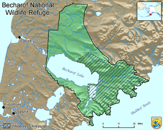
Becharof National Wildlife Refuge is a National Wildlife Refuge in the Aleutian Range of the Alaska Peninsula of southwestern Alaska. It is adjacent to Katmai National Park and Preserve. This national wildlife refuge, which covers an area of 1,200,000 acres (4,900 km2), was established in 1980 to conserve major brown bears, salmon, migratory birds, caribou, marine birds, and mammals and to comply with treaty obligations. It lies primarily in the east-central part of Lake and Peninsula Borough, but extends eastward into the mainland portion of Kodiak Island Borough. The refuge is administered from offices in King Salmon.
McNary National Wildlife Refuge is a wildlife preserve, one of the national wildlife refuges operated by the United States Fish and Wildlife Service. Extending along the east bank of the Columbia River in southeastern Washington, from the confluence of the Snake River to the mouth of the Walla Walla River, and downstream into Oregon, McNary NWR is located in rural Burbank, but very close to the rapid development of the Tri-Cities. In fact, the refuge meets the definition of an "urban refuge." Few areas in North America support waterfowl populations in the extraordinary numbers found here. There are spectacular concentrations of Canada geese, mallards, and other waterfowl. More than half the mallards in the Pacific Flyway overwinter at some time in this portion of the Columbia River Basin.

Humboldt Bay National Wildlife Refuge is located on Humboldt Bay, on the California North Coast near the cities of Eureka and Arcata. The refuge exists primarily to protect and enhance wetland habitats for migratory water birds using the bay area, including tens of thousands of shorebirds, ducks, geese, swans, and the black brant. Humboldt Bay National Wildlife Refuge, along with other public and private lands around Humboldt Bay, is one of the key stopovers for the millions of migratory birds that rely on the Pacific Flyway. More than 200 bird species, including 80 kinds of water birds and four endangered species, regularly feed, rest, or nest on the refuge or other areas around the bay.

The Alaska Peninsula montane taiga is a taiga and boreal forests ecoregion, located in Alaska, and defined by the World Wildlife Fund (WWF) categorization system.

The Beringia lowland tundra is a tundra ecoregion of North America, on the west coast of Alaska, mostly covered in wetland.
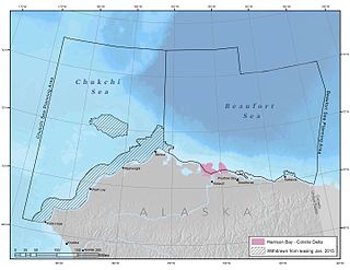
Harrison Bay is an estuary located north of Alaska that opens into the Beaufort Sea. It is adjacent to the Colville Delta. The powerful outflow of the Colville River creates a shallow region that is rich with nutrients, making it ecologically significant for wildlife.
The Simeonof Wilderness is a wilderness area in Aleutians East Borough, Alaska. The area was designated in 1976 by the United States Congress and is currently managed by the Alaska Maritime National Wildlife Refuge. The Simeonof Wilderness is located on homonymous Simeonof Island in the Shumagin Island group.