Related Research Articles
Borchgrevink Glacier is a large glacier in the Victory Mountains, Victoria Land, Antarctica. It drains south between Malta Plateau and Daniell Peninsula, and thence projects into Glacier Strait, Ross Sea, as a floating glacier tongue.
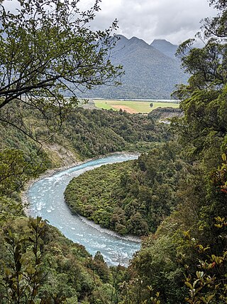
The Kaniere River is a river of New Zealand. It is located in the West Coast Region of the South Island. The river is the outflow of Lake Kaniere, and flows west to reach the Hokitika River five kilometres from the coast of the Tasman Sea.

The Kokatahi River is a river of the West Coast Region of New Zealand's South Island. A major tributary of the Hokitika River, it flows northwest from its origins on the northern slopes of Mount Ambrose, reaching the Hokitika River 12 kilometres from the latter's mouth at Hokitika. The two rivers between them share one of the West Coast's larger floodplains.
The Motupiko River is a river of the Tasman Region of New Zealand's South Island. A major tributary of the Motueka River, it flows north from its origins southeast of the Hope Saddle, meeting the Motueka at Kohatu Junction, 15 kilometres west of Wakefield. The Motupiko's tributaries include the Rainy River.

The Mungo River is a river of the West Coast Region of New Zealand's South Island. The major source of the Hokitika River, it flows generally west from the Southern Alps, becoming the Hokitika River at the point where it turns north as it flows through a gap in the Diedrichs Range. The Hokitika Saddle separates the headwaters of the Mungo from those of the Rakaia River system which flows to the island's east coast.
The Nancy River is a river of the West Coast Region of New Zealand's South Island. A tributary of the Ahaura River, it flows generally southwest from its source to the west of Mount Hochstsetter in the Southern Alps, turning west shortly before its outflow, 15 kilometres southeast of Lake Hochstetter.
The Okari River is a river of the West Coast Region of New Zealand's South Island. The river flows northwest from its sources at the northern end of the Paparoa Range crossing the swampy terrain of Addisons Flat to reach the Tasman Sea eight kilometres south of Cape Foulwind.
The Ōrangipuku River is a river of the West Coast Region of New Zealand's South Island. It flows north into the southern end of Lake Brunner.
The Pahau River or Pahu River is a river of the north Canterbury region of New Zealand's South Island. It has its origins in the Tekoa Range, 25 kilometres (16 mi) northwest of Culverden, and flows initially north before turning south to flow down a long valley between two ridges. At the northern edge of the Canterbury Plains it turns southeast, flowing past the southern outskirts of Culverden to reach the Hurunui River 8 kilometres (5 mi) southeast of the town.
The Penk River is a river of the Marlborough Region of New Zealand's South Island. It flows predominantly south from its origins on the slopes of Mount Horrible to reach the Awatere River 35 kilometres (22 mi) southwest of Seddon.
The Snowy River is a river of the West Coast Region of New Zealand's South Island. It flows generally west from its sources within Victoria Forest Park, and is one of the rivers whose courses mark the edges of the Ikamatua Plain. The Snowy River joins with the Blackwater River 100 metres prior to its junction with the Māwheraiti River two kilometres north of the township of Ikamatua.
The Te Wharau or Stony River is a river of the West Coast Region of New Zealand's South Island. It flows generally east from its sources in the Paparoa Range to reach the Inangahua River 15 kilometres north of Reefton.

The Toaroha River is a river of the West Coast Region of New Zealand's South Island. It flows generally north through a valley between the Toaroha and Diedrichs Ranges to reach the Kokatahi River 25 kilometres southeast of Hokitika.
The Waikākaho River is a river of the Marlborough Region of New Zealand's South Island. It flows south from its sources southeast of Havelock to reach the Wairau River 5 kilometres (3 mi) west of Tuamarina.
The Whareatea River is a river of the West Coast Region of New Zealand's South Island. It flows generally northwest to reach the Tasman Sea five kilometres to the east of Westport.

The Whitcombe River is a river of the West Coast Region of New Zealand's South Island. It flows north to reach the Hokitika River 30 kilometres south of Hokitika.
The Land Glacier is a broad, heavily crevassed glacier, about 35 nautical miles long, descending into Land Bay in Marie Byrd Land, Antarctica. It was discovered by the United States Antarctic Service (1939–41) and named for Rear Admiral Emory S. Land, Chairman of the United States Maritime Commission.
The Taipo River is a river of the central West Coast Region of New Zealand's South Island. It flows north from its sources west of Mount Rolleston, fed by the waters of several mountain streams. After some 15 kilometres it turns northeast to flow past the Bald Range before reaching the valley of the Taramakau River into which it flows 35 kilometres east of Hokitika.
The Tōtara River is a river of the northern West Coast Region of New Zealand's South Island. It rises near Mount Kelvin in the Paparoa Range and flows northwest to reach the Tasman Sea 10 kilometres south of Cape Foulwind. The Little Totara River joins the Tōtara just before it reaches the sea.

The Blackwater River is located in the Buller District of New Zealand. It flows north-northwest for 19 kilometres (12 mi) from the northern slopes of Mount Copernicus in the Paparoa Range, reaching the Buller River 16 kilometres (9.9 mi) west of Inangahua in the lower Buller Gorge.
References
- "Place name detail: Orikaka River". New Zealand Gazetteer. New Zealand Geographic Board . Retrieved 12 July 2009.
| International | |
|---|---|
| National | |
41°50′S171°54′E / 41.833°S 171.900°E