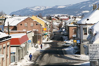
Stjørdal or Skierde is a municipality in Trøndelag county, Norway. It is part of the Stjørdalen region. The administrative centre of the municipality is the town of Stjørdal, also called Stjørdalshalsen. Some of the villages in the municipality include Elvran, Flornes, Hegra, Hell, Kvithammer, Prestmoen, Skatval, Skjelstadmarka, Sona, and Værnes.

Saltdal is a municipality in Nordland county, Norway. It is part of the traditional district of Salten. The administrative centre of the municipality is the village of Rognan. Other villages in Saltdal include Røkland and Lønsdal.

Svene is a village in the municipality of Flesberg in Buskerud, Norway. It is located in Numedal, 10 kilometres from Kongsberg. Its population (2017) is 376.

Sysle is a village in the municipality of Modum, Buskerud county, Norway. Its population (2014) is 227.
Folkestad is a village in Bø municipality, Norway. Its population is 422.

Dalen is the administrative centre of Tokke municipality, Norway. Its population is 801. Dalen is located on and around the delta where the river Tokke flows into the west end of the lake Bandak.
Yli is a village in Notodden municipality, Norway. It is located west of Notodden city, across the river Heddøla. Its population is 324.
Herre is a village in Bamble municipality, Norway. It is located west of Porsgrunn, across the Frierfjord. Its population is 1,356.
Båtstø is a small village in Buskerud, Norway.

Skrova is a small island group and village area in Vågan Municipality in Nordland county, Norway. The 2.5-square-kilometre (0.97 sq mi) Skrova island group in the Lofoten archipelago, about 9 kilometres (5.6 mi) southeast of the town of Svolvær. It is located in the Vestfjorden, south of the islands of Austvågøya, Litlmolla, and Stormolla. The largest island in the group is Storskrova and the island of Heimskrova is where most of the population is located. The six main inhabited islands in the group are all interconnected by a small bridge and several man-made causeways.

Feda is a village in Kvinesdal municipality in Vest-Agder county, Norway. The village is located on the north side of the Fedafjorden, about 10 kilometres (6.2 mi) southwest of the village of Liknes and about 12 kilometres (7.5 mi) east of the town of Flekkefjord. The 0.49-square-kilometre (120-acre) village has a population (2015) of 404, giving the village a population density of 824 inhabitants per square kilometre (2,130/sq mi).
Prestestranda is the administrative centre of Drangedal municipality, Norway. Its population is 1,223.
Buerstad is a village and statistical area (grunnkrets) in Nøtterøy municipality, Norway.
Torød is a village and statistical area (grunnkrets) in Nøtterøy municipality, Norway. it was also taken over by the Germans and soldiers lived in some houses. The statistical area Torød, which also can include the peripheral parts of the village as well as the surrounding countryside, has a population of 637.

Årøysund is a village and statistical area (grunnkrets) in Nøtterøy municipality, Norway.
Ormelet is a village and statistical area (grunnkrets) in Tjøme municipality, Norway.

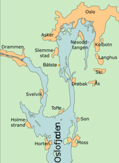
Lierbyen is the administrative center of Lier municipality in Buskerud county, Norway. The village is situated on the Lierelva River in the valley of Lierdalen which extends from Drammensfjord north toward Sylling near Tyrifjorden. Lierbyen is located about 39 km from Oslo, about 8 km from Drammen off European route E18. Lierbyen is a part of a greater urban area which also encompasses the villages Lier, Reistad and Kjellstad. The urban area has a population of 4,233 (2007)..

Tranby is a village in Lier municipality in Buskerud, Norway. Tranby is located approximately 25 minutes drive southwest of Oslo and 10 minutes drive north of Drammen.

Krvojevići is a village in the Republika Srpska, Bosnia and Herzegovina. According to the 1991 census, the village is located in the municipality of Rogatica.
Katun is a village in the municipality of Vranje, Serbia. According to the 2002 census, the village has a population of 432 people.