
The Ahuriri River is a river in the Otago region of the South Island of New Zealand.

The Mackenzie River is a river in the South Island of New Zealand.
Waitaki District is a territorial authority that is located in the Canterbury and Otago regions of the South Island of New Zealand, and it straddles the traditional border between the two regions, the Waitaki River.
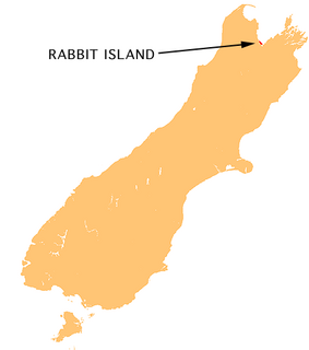
Moturoa / Rabbit Island is a small island located in the southernmost part of the Tasman Bay, in the northern coast of New Zealand's South Island. It lies across the southernmost part of Tasman Bay, at the top of New Zealand's South Island. The long narrow island runs east-west for 8 kilometres (5 mi), and covers 15 km2 (5.8 sq mi).
The Hakataramea River flows generally south through the Hakataramea Valley, which is separated from the more inland Mackenzie Basin by the Kirkliston Range in Canterbury, New Zealand.

The Godley River is an alpine braided river flowing through Canterbury, in New Zealand's South Island.
The Grays River is a tributary of the Tekapo River in the Mackenzie Basin of New Zealand. It flows southwest for 25 kilometres (16 mi), joining the larger river southeast of Lake Pukaki.
The Maerewhenua River, also known as the Marewhenua River, is a small river in the Otago region of New Zealand's South Island. It is located in North Otago and acts as a tributary of the Waitaki River, which forms the border between Otago and Canterbury.

Hakataramea, spelt Hakateramea in some older sources, is a rural village located in the southern Canterbury region of New Zealand's South Island. It is in the Waimate District and sits on the north bank of the Waitaki River at its confluence with the Hakataramea River.
The Kurow River is a river of North Otago, New Zealand. A tributary of the Waitaki River, it rises in Saint Marys Range and flows into that river downstream of Kurow.
The Little Awakino River is a river of North Otago, New Zealand. A tributary of the Waitaki River, it flows into that river a short distance downstream of Lake Waitaki.
The Little Opawa River is a river of the south Canterbury Region of New Zealand's South Island. It flows generally east from a ridge 20 kilometres (12 mi) southwest of Fairlie, joining with its southern neighbour, the Ōpaoa River very close to their joint outflow into the Tengawai River, close to the settlement of Albury.
The North Barlow River is a river in the West Coast Region of New Zealand's South island. It is one of the headwaters of the Barlow River.
The Otamatapaio River is a river in North Otago, New Zealand. It rises in the Hawkdun Range and flows north-eastward into Lake Benmore.
The Otekaieke River is a river in New Zealand, a tributary of the Waitaki River.
The Otematata River is a river in North Otago, New Zealand. It rises west of Kohurau and flows northward into Lake Aviemore east of Otematata township.
The Pitt River is a river in Fiordland, New Zealand. It rises north-west of Oilskin Pass and flows north-westward into Lake Beddoes.
The Teviot River is a river in New Zealand, a tributary of the Clutha River.
Scott Icefalls is an extensive icefalls near the head of Mill Glacier, between Otway Massif and the south part of Dominion Range. Named by the New Zealand Geological Survey Antarctic Expedition (NZGSAE) (1961–62) for Captain Robert F. Scott.
The White Rock River is a river in the South Canterbury area of New Zealand. It rises south of the 1,525 metres (5,003 ft) Mount Nimrod / Kaumira in the Hunter Hills and flows northeast then north to joint the Pareora River.


