The Namibian economy has a modern market sector, which produces most of the country's wealth, and a traditional subsistence sector. Although the majority of the population engages in subsistence agriculture and herding, Namibia has more than 200,000 skilled workers and a considerable number of well-trained professionals and managerials.

Walvis Bay, meaning "Whale Bay", is a city in Namibia and the name of the bay on which it lies. The town covers a total area of 29 square kilometres (11 sq mi) of land.
The history of Namibia has passed through several distinct stages from being colonised in the late nineteenth century to Namibia's independence on 21 March 1990.

Windhoek, (pronunciation:), is the capital and largest city of the Republic of Namibia. It is located in central Namibia in the Khomas Highland plateau area, at around 1,700 metres (5,600 ft) above sea level, almost exactly at the country's geographical centre. The population of Windhoek in 2011 was 325,858, growing continually due to an influx from all over Namibia.
ǂKxʼaoǁʼae, or Gobabi !Kung (Gobabis-!Xû), is a southeastern dialect of the ǃKung language, spoken in Botswana and in Namibia by about 7,000 people. In Botswana, most speakers are bilingual in Naro or Tswana.

Gobabis is a city in eastern Namibia. It is the regional capital of the Omaheke Region, and the district capital of the Gobabis electoral constituency. Gobabis is situated 200 km (120 mi) down the B6 motorway from Windhoek to Botswana. The town is 113 km (70 mi) from the Buitepos border post with Botswana, and serves as an important link to South Africa on the tarred Trans-Kalahari Highway. Gobabis is in the heart of the cattle farming area. In fact Gobabis is so proud of its cattle farming that a statue of a large Brahman bull with the inscription "Cattle Country" greets visitors to the town. Gobabis also has its own local Airport.
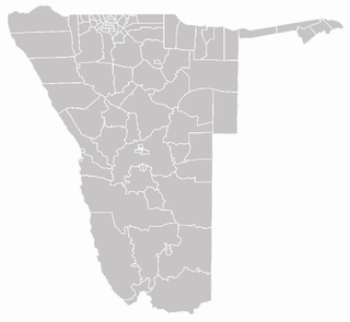
Each of the 14 regions in Namibia is further subdivided into electoral constituencies. The size of the constituencies varies with the size and population of each region. There are currently 121 constituencies in Namibia. The most populous constituency is Walvis Bay Urban; the least populous is Walvis Bay Rural, both in the Erongo region.

Ruacana is a town in Omusati Region, northern Namibia and the district capital of the Ruacana electoral constituency. It is located on the border with Angola on the river Kunene. The town is known for the picturesque Ruacana Falls nearby, and for the Ruacana Power Station.
Otjimbingwe is a settlement in the Erongo Region of central Namibia. It has approximately 8,000 inhabitants.
The Oorlam or Orlam people are a subtribe of the Nama people, largely assimilated after their migration from the Cape Colony to Namaqualand and Damaraland.
Eenhana is the capital town of the Ohangwena Region, northern Namibia, on the border with Angola. It also used to be a mission station of the Finnish Missionary Society.
Lesbian, gay, bisexual, and transgender (LGBT) persons in Namibia face legal challenges not experienced by non-LGBT residents. Discrimination based on sexual orientation and gender identity is not banned in Namibia. Households headed by same-sex couples are not eligible for the same legal protections available to opposite-sex couples.
Ongwediva is a town in the Oshana Region in the north of Namibia. It is the district capital of the Ongwediva electoral constituency. As of 2010 it had 27,000 inhabitants and covered 4,102 hectares of land. Ongwediva has seven churches, two private schools and 13 government-run schools. Most of the inhabitants speak Oshiwambo.
White Namibians are people of European birth or descent living in Namibia. The majority of white Namibians are Afrikaners, with a large minority being German Namibians (descended from Germans who colonised Namibia in the late 19th century). Many are also Portuguese or English immigrants. Current estimates of the white Namibian population run between 75,000 and 100,000. This discrepancy in data is because the Namibian government no longer collects data based on race.
Endola is a constituency in the Ohangwena Region of Namibia, on the border of Angola. It has 36,659 inhabitants, the district centre is the settlement of Endola. Ferdinand Ingashipola Shifidi became a councillor of the constituency in November 2014 and was re-elected in 2015.
Helao Nafidi is a town in Ohangwena Region in northern Namibia at the border to Angola. It has been established in 2004 as an amalgamation of several villages and settlements along the main road between Oshikango and Ohangwena which are both also part of the town. Helao Nafidi has 19,375 inhabitants. The town is separated into three urban areas, Oshikango in the north, bisected by the Namibian–Angolan border, and Omafo and Ohangwena south of it, with settlements and villages in the agricultural area between them.

Aminuis is a cluster of small settlements in the remote eastern part of the Omaheke Region of Namibia, located about 500 km east of Windhoek. It is the district capital of the Aminuis electoral constituency.
Tsintsabis is a settlement of about 4,000 inhabitants in the Oshikoto Region of Namibia. It is situated c. 65 kilometres (40 mi) northeast of Tsumeb and belongs to the Guinas electoral constituency. The settlement features a clinic and a Police station. Tsintsabis is not a proclaimed settlement. It is situated on farm land, some of which has been obtained by government to resettle landless people. The area is inhabited predominantly by San people but also by Damara, Ovambo and people from the Kavango Region.


