
A ring road is a road or a series of connected roads encircling a town, city or country. The most common purpose of a ring road is to assist in reducing traffic volumes in the urban centre, such as by offering an alternate route around the city for drivers who do not need to stop in the city core. Ring roads can also serve to connect suburbs to each other, allowing efficient travel between them.

The County of London Plan was prepared for the London County Council in 1943 by John Henry Forshaw (1895–1973) and Sir Leslie Patrick Abercrombie (1879–1957).

The A4150 Wolverhampton Inner Ring Road is a ring road that encircles the city centre of Wolverhampton in the West Midlands, England. The circumference of the road is around 2.1 miles (3.4 km). Technically, the route is listed as an "Inner Ring Road", although only a tiny section of the "Outer Ring Road" was ever constructed with only one of the two designed carriageways built. A second carriageway was built in 2017 along a short stretch between Patshull Avenue and Stafford Road. The section of outer ring road is called Wobaston Road and locally classified by Wolverhampton City Council as U119.

The R136 road is a regional road in Ireland, located in the southwest of Dublin. Named the Outer Ring Road, the route, which is dual carriageway, runs from the N4 at Lucan to the N81 at Tallaght, bypassing west of Clondalkin and crossing the N7 near Citywest. It was built as part of the planning for the new town of Adamstown.

The London Ringways were a series of four ring roads planned in the 1960s to circle London at various distances from the city centre. They were part of a comprehensive scheme developed by the Greater London Council (GLC) to alleviate traffic congestion on the city's road system by providing high-speed motorway-standard roads within the capital, linking a series of radial roads taking traffic into and out of the city.

The R710 road is a regional road in Ireland. Located in the south of Ireland at Waterford, it forms the Outer Ring Road around the south of the city. As of December 2006 it commences on the Old Kilmeaden Road at Knockhouse Lower, west of Waterford City and ends at a junction with the R683 on the Dunmore Road in the south-east of the city.

Bundesautobahn 99 is an autobahn in southern Germany. It is the Munich outer ring road.

Großhesselohe Isartalbahn station is a station on the Isar Valley Railway from Munich to Bichl in the German state of Bavaria. Since 1981, it has been a station of the Munich S-Bahn. The station is located in the municipality of Pullach, which also contains the stations of Pullach and Höllriegelskreuth. It is classified by Deutsche Bahn as a category 5 station and has two platform tracks. The station building is registered as a historic building on the List of Bavarian Monuments.

Bundesautobahn 100 is an Autobahn in Germany.

The Singelgracht is a semi-circular waterway that borders the entire city centre of Amsterdam, Netherlands. The canal runs along the Nassaukade, Stadhouderskade and Mauritskade streets. Formerly part of the ramparts, it formed the outer defenses of the city.
The Munich–Holzkirchen railway is a continuously-electrified, double-track, railway in the German state of Bavaria. It runs from Munich to Holzkirchen via Deisenhofen.
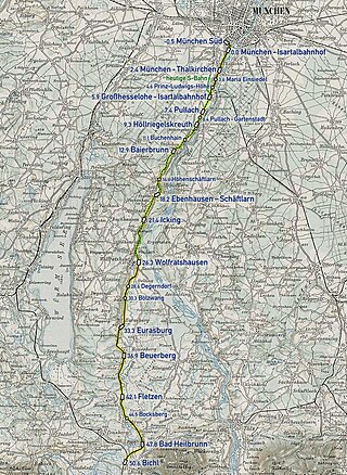
The Isar River Valley Railway is a standard gauge and electrified railway in the German state of Bavaria. Originally it was 51.1 km long, running from Munich South station to Bichl and was built from 1891 to 1898 in sections by the Lokalbahn AG company (LAG). The section from Munich South to Wolfratshausen was classified as a main line, while the section from Wolfratshausen to Bichl was classified as a branch line. In 1900, the LAG electrified the section from the Isartalbahnhof to Höllriegelskreuth for suburban services at 580 volts DC. In 1938, the LAG and, with it, the Isar Valley Railway were nationalised. After the Second World War, Deutsche Bundesbahn converted the electrification to 15 kV AC ; this was completed in 1955 and extended to Wolfratshausen in 1960. The northern section from Munich South to Grosshesselohe Isartal station and the southern section from Wolfratshausen to Bichl was closed by Deutsche Bundesbahn between 1959 and 1972. The middle section is now used by line S 7 of the Munich S-Bahn. The name of the line refers to the Isar as the northern half of the line follows the river's western bank. On the other hand, the southern section is located in the valley of the Loisach.
The Munich East–Munich Airport railway is a double-track and electrified main line in the German state of Bavaria that connects the city of Munich to Munich Airport, which is located 30 kilometres to the northeast. It is operated of DB Netz AG and integrated in the Munich S-Bahn as part of line S 8.
D0 motorway or Prague Ring Road is a motorway which, when completed, would create an outer ring road around in Prague, Czech Republic. Most of the Czech motorways radiate from the D0. Unlike the inner ring road, whose sub-sections have been given different official street names, the Prague Ring Road is also the official name of a street in all parts of the ring road leading through Prague.

The Fraunhoferstraße is a city center street in Munich. It is located in the district of Isarvorstadt and separates the Gärtnerplatzviertel in the north from the Glockenbachviertel in the south.
The Widenmayerstraße is an inner city street in the Munich district of Lehel. It is registered as a protected ensemble in the Bavarian protected monument list.

The Landsberger Straße is one of the main arterial roads in Munich.

Wolfratshauser Straße is a major road in Munich. It forms part of the Bundesstraße 11 and is named after the city Wolfratshausen south of Munich, in whose direction it leads.
Boschetsrieder Straße is an inner city street in the Munich districts of Thalkirchen, Obersendling and Forstenried/Am Waldfriedhof, which runs west from Bundesstraße 11 on the Isar hillside to Kreuzhof, where it continues as the Fürstenrieder Straße.

Candidstraße is an inner-city street in Munich and a section of the Mittlerer Ring.
