
Bay Street is a major thoroughfare in Downtown Toronto, Ontario, Canada. It is the centre of Toronto's Financial District and is often used by metonymy to refer to Canada's financial services industry since succeeding Montreal's St. James Street in that role in the 1970s.

Trinity—Spadina was a federal electoral district in Ontario, Canada, that was represented in the House of Commons of Canada from 1988 to 2015.
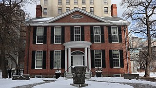
Campbell House is an 1822 heritage house and museum in downtown Toronto, Ontario, Canada. It was built for Upper Canada Chief Justice Sir William Campbell and his wife Hannah. The home was designed for entertaining and comfort, and constructed at a time when the Campbells were socially and economically established and their children had grown to adulthood. The house is one of the few remaining examples of Georgian architecture left in Toronto and is constructed in a style in vogue during the late Georgian era known as Palladian architecture.

One Yonge Street is a 25-storey office building in Toronto, Ontario, Canada. The building served as the headquarters of Torstar and its flagship newspaper, the Toronto Star, from 1971 to 2022. It is 100 metres tall and built in the International style. It was built as a replacement to the Old Toronto Star Building, which was located at 80 King Street West. That building was torn down to make room for First Canadian Place.

The Woolworth building, located at Queen Street West and Yonge Street in downtown Toronto, pre-dates the Toronto Eaton Centre.

The Salvation Army Toronto Grace Health Centre is a 150-bed hospital located at 650 Church Street in Toronto, Ontario. Owned and operated by the Salvation Army, it specializes in palliative care, post-acute care rehabilitation, and complex continuing care.

John Street is a street in Downtown Toronto. It runs from Stephanie Street and Grange Park in the north to the Metro Toronto Convention Centre on Front Street in the south. It is home to a number of Toronto's cultural institutions, including buildings for the CBC, CTV, Toronto International Film Festival. The National Post has described it as "Running directly through the entertainment district, its spine connects many great cultural institutions, popular retail outlets, restaurants and soon-to-be-built condos." The City of Toronto has dubbed the street a "Cultural Corridor" and a report calls it "the centrepiece of the Entertainment District."

SP!RE is a high-rise condominium building located at 70 Adelaide Street East at Church Street in downtown Toronto, Ontario, Canada by Context Developments. Construction was completed in 2007.

The Grand Opera House was an opera house and concert hall located in Toronto, Ontario, Canada.

The Simpson Tower, located at 401 Bay Street, is the 38th-tallest building in Toronto, Ontario, Canada. Completed in 1968 by John B. Parkin Associates and Bregman & Hamann, as the headquarters of the Simpsons department store company, it has 33 floors and is 144 m (472 ft) high. In 1978, as part of a corporate takeover, the Simpson Tower became the property of the Hudson's Bay Company. The building today remains the head office of HBC and also houses the head office of subsidiaries Hudson's Bay and Home Outfitters. It is adjacent to the historic Simpsons store at Yonge and Queen, which includes Arcadian Court. Today the store is the flagship for Hudson's Bay, is integrated with the Eaton Centre across Queen Street, and is the home of Toronto's comprehensive health centre.

The Ward was a neighbourhood in central Toronto, Ontario, Canada, in the 19th and early 20th centuries. Many new immigrants first settled in the neighbourhood; it was at the time widely considered a slum.

Richmond-Adelaide Centre is a cluster of office buildings in Toronto, Ontario, Canada, located in the financial district. It is bounded by Richmond Street West to the north, Sheppard Street to the east, Adelaide Street West to the south, and finally York Street as its western boundary. The complex is owned and operated by global real estate investor, developer and owner of Oxford Properties Group.
St. Andrew's Playground is a small park in downtown Toronto. It is located at the 450 Adelaide Street West, at the northwest corner of Brant St and Adelaide. It has a playground for children and an off-leash area for dogs that is surrounded by a short fence, with an accessible water fountain for pets, children, and adults. A Heritage Toronto plaque in the northwest corner describing the history and significance of the park was installed in 2007.

Pinnacle Centre is a condominium tower complex in Toronto, Ontario. The complex consists of four towers located on former railway lands on the Toronto waterfront. It is one of a number of new condominium projects in the area, the most notable being nearby Maple Leaf Square and CityPlace developments to the west. The Pinnacle Centre site is bounded by Yonge Street to the east, Harbour Street to the south, Bay Street to the west, and the Gardiner Expressway to the north. It was built by Vancouver−based Pinnacle International. It has 1,880 residences on approximately 3.8 acres of land.

The EY Tower is a skyscraper in Toronto, Ontario, Canada at 100 Adelaide Street West. The building was designed by Kohn Pedersen Fox and WZMH Architects.

Railway Lands is an area in Downtown Toronto, Ontario, Canada. Originally a large railway switching yard near the Toronto waterfront, including the CNR Spadina Roundhouse and the CPR John Roundhouse, it has since been redeveloped and today is home to mostly mixed-used development, including the CN Tower and the Rogers Centre. The lands were owned and maintained by the Canadian National Railway and later transferred to the federal crown corporation Canada Lands Company. The area is bounded by Front Street, Yonge Street, Gardiner Expressway and Bathurst Street. The western portion of the Railway Lands is now part of the CityPlace neighbourhood and the eastern portion is now called South Core.

The Paul Bishop's House is actually a pair of historic townhouses located at 363-365 Adelaide Street East in the St. Lawrence neighborhood downtown Toronto, Ontario, Canada. The houses, constructed in 1848 by Paul Bishop, sit upon the foundations laid by William Jarvis for his home in 1798. Jarvis was a member of the Queen's Rifles and Provincial Secretary and Registrar of Upper Canada. He selected a site at what is now the southeast corner of Sherbourne and Adelaide Streets and constructed a 30 by 41 foot building of squared logs that he covered with clapboards which he named Jarvis House.

Massey Tower is a new complex in Toronto, Ontario, Canada, spanning the block below Shuter Street, between Yonge and Victoria streets. The complex's northeast corner added much-needed backstage space to historic Massey Hall. To the south of the complex lies the historic Elgin and Winter Garden Theatres. The Yonge Street facade uses the 1905 Canadian Bank of Commerce headquarters at 197 Yonge Street, vacant since 1987. The complex's tower rises 60 storeys and stands 208.3 metres (683 ft) in height.
The CIL Building is a fourteen-storey office tower located at 130 Bloor Street West in Toronto, Ontario. Designed by the architectural firm Bregman and Hamann and completed in 1960, the building is one of Toronto's best examples of International Style architecture. The CIL building is best known for its two-storey penthouse, which was originally occupied by businessman Noah Torno and is now a designated historic property.

Chinatown, Toronto is a Chinese ethnic enclave located in the city's downtown core of Toronto, Ontario, Canada. It is centred at the intersections of Spadina Avenue and Dundas Street West.

