
Pachachaca is a river and valley of the Andes in Peru. Abancay lies on the river and in flows through the Ampay National Sanctuary. It is a notable kayaking location.
Pachachaca is a river and valley of the Andes in Peru. Abancay lies on the river and in flows through the Ampay National Sanctuary. It is a notable kayaking location.
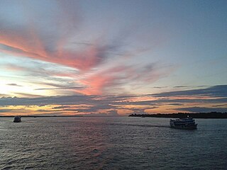
The Amazon River in South America is the largest river by discharge volume of water in the world, and the disputed longest river system in the world in comparison to the Nile.

The Yangtze or Yangzi is the longest river in Eurasia, the third-longest in the world, and the longest in the world to flow entirely within one country. It rises at Jari Hill in the Tanggula Mountains of the Tibetan Plateau and flows 6,300 km (3,900 mi) in a generally easterly direction to the East China Sea. It is the seventh-largest river by discharge volume in the world. Its drainage basin comprises one-fifth of the land area of China, and is home to nearly one-third of the country's population.

The Ganges is a trans-boundary river of Asia which flows through Bangladesh and India. The 2,525 km (1,569 mi) river rises in the western Himalayas in the Indian state of Uttarakhand. It flows south and east through the Gangetic plain of North India, receiving the right-bank tributary, the Yamuna, which also rises in the western Indian Himalayas, and several left-bank tributaries from Nepal that account for the bulk of its flow. In West Bengal state, India, a feeder canal taking off from its right bank diverts 50% of its flow southwards, artificially connecting it to the Hooghly river. The Ganges continues into Bangladesh, its name changing to the Padma. It is then joined by the Jamuna, the lower stream of the Brahmaputra, and eventually the Meghna, forming the major estuary of the Ganges Delta, and emptying into the Bay of Bengal. The Ganges-Brahmaputra-Meghna system is the second largest river on earth by discharge.

Idaho is a state in the Pacific Northwest region of the Western United States. To the north, it shares a small portion of the Canada–United States border with the province of British Columbia. It borders the states of Montana and Wyoming to the east, Nevada and Utah to the south, and Washington and Oregon to the west. The state's capital and largest city is Boise. With an area of 83,570 square miles (216,400 km2), Idaho is the 14th largest state by land area, but with a population of approximately 1.8 million, it ranks as the 13th least populous and the 7th least densely populated of the 50 U.S. states.

The IndusIN-dəs is a transboundary river of Asia and a trans-Himalayan river of South and Central Asia. The 3,120 km (1,940 mi) river rises in mountain springs northeast of Mount Kailash in Western Tibet, flows northwest through the disputed region of Kashmir, bends sharply to the left after the Nanga Parbat massif, and flows south-by-southwest through Pakistan, before emptying into the Arabian Sea near the port city of Karachi.

The Mississippi River is the second-longest river and chief river of the second-largest drainage system in North America, second only to the Hudson Bay drainage system. From its traditional source of Lake Itasca in northern Minnesota, it flows generally south for 2,340 miles (3,770 km) to the Mississippi River Delta in the Gulf of Mexico. With its many tributaries, the Mississippi's watershed drains all or parts of 32 U.S. states and two Canadian provinces between the Rocky and Appalachian mountains. The main stem is entirely within the United States; the total drainage basin is 1,151,000 sq mi (2,980,000 km2), of which only about one percent is in Canada. The Mississippi ranks as the thirteenth-largest river by discharge in the world. The river either borders or passes through the states of Minnesota, Wisconsin, Iowa, Illinois, Missouri, Kentucky, Tennessee, Arkansas, Mississippi, and Louisiana.

The Nile is a major north-flowing river in northeastern Africa. It flows into the Mediterranean Sea. The Nile is the longest river in Africa and has historically been considered the longest river in the world, though this has been contested by research suggesting that the Amazon River is slightly longer. Of the world's major rivers, the Nile is one of the smallest, as measured by annual flow in cubic metres of water. About 6,650 km (4,130 mi) long, its drainage basin covers eleven countries: the Democratic Republic of the Congo, Tanzania, Burundi, Rwanda, Uganda, Kenya, Ethiopia, Eritrea, South Sudan, Republic of the Sudan, and Egypt. In particular, the Nile is the primary water source of Egypt, Sudan and South Sudan. Additionally, the Nile is an important economic river, supporting agriculture and fishing.

The Ohio River is a 981-mile (1,579 km) long river in the United States. It is located at the boundary of the Midwestern and Southern United States, flowing in a southwesterly direction from western Pennsylvania to its mouth on the Mississippi River at the southern tip of Illinois. It is the third largest river by discharge volume in the United States and the largest tributary by volume of the north-south flowing Mississippi River that divides the eastern from western United States. It is also the 6th oldest river on the North American continent. The river flows through or along the border of six states, and its drainage basin includes parts of 14 states. Through its largest tributary, the Tennessee River, the basin includes several states of the southeastern U.S. It is the source of drinking water for five million people.

The Hudson River is a 315-mile (507 km) river that flows from north to south primarily through eastern New York. It originates in the Adirondack Mountains of Upstate New York and flows southward through the Hudson Valley to the New York Harbor between New York City and Jersey City, eventually draining into the Atlantic Ocean at Lower New York Bay. The river serves as a physical boundary between the states of New Jersey and New York at its southern end. Farther north, it marks local boundaries between several New York counties. The lower half of the river is a tidal estuary, deeper than the body of water into which it flows, occupying the Hudson Fjord, an inlet which formed during the most recent period of North American glaciation, estimated at 26,000 to 13,300 years ago. Even as far north as the city of Troy, the flow of the river changes direction with the tides.

The Oregon Trail was a 2,170-mile (3,490 km) east–west, large-wheeled wagon route and emigrant trail in the United States that connected the Missouri River to valleys in Oregon. The eastern part of the Oregon Trail spanned part of what is now the state of Kansas and nearly all of what are now the states of Nebraska and Wyoming. The western half of the trail spanned most of the current states of Idaho and Oregon.
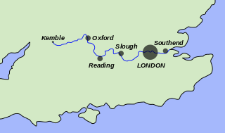
The River Thames, known alternatively in parts as the River Isis, is a river that flows through southern England including London. At 215 miles (346 km), it is the longest river entirely in England and the second-longest in the United Kingdom, after the River Severn.

The Midwestern United States, also referred to as the Midwest or the American Midwest, is one of four census regions of the United States Census Bureau. It occupies the northern central part of the United States. It was officially named the North Central Region by the Census Bureau until 1984. It is between the Northeastern United States and the Western United States, with Canada to the north and the Southern United States to the south.

River Jude Phoenix was an American actor, singer, musician, songwriter, and activist.

The Colorado River is one of the principal rivers in the Southwestern United States and in northern Mexico. The 1,450-mile-long (2,330 km) river drains an expansive, arid watershed that encompasses parts of seven U.S. states and two Mexican states. The name Colorado derives from the Spanish language for "colored reddish" due to its heavy silt load. Starting in the central Rocky Mountains of Colorado, it flows generally southwest across the Colorado Plateau and through the Grand Canyon before reaching Lake Mead on the Arizona–Nevada border, where it turns south toward the international border. After entering Mexico, the Colorado approaches the mostly dry Colorado River Delta at the tip of the Gulf of California between Baja California and Sonora.

The Brahmaputra is a trans-boundary river which flows through Tibet, Northeastern India, and Bangladesh. It is also known as the Yarlung Tsangpo in Tibetan, the Siang/Dihang River in Arunachali, Luit and Brahmaputra in Assamese, and Jamuna River in Bangla. It is the 9th largest river in the world by discharge, and the 15th longest.

The Ozarks, also known as the Ozark Mountains, Ozark Highlands or Ozark Plateau, is a physiographic region in the U.S. states of Missouri, Arkansas, Oklahoma and the extreme southeastern corner of Kansas. The Ozarks cover a significant portion of northern Arkansas and most of the southern half of Missouri, extending from Interstate 40 in central Arkansas to Interstate 70 in central Missouri.

Joan Alexandra Molinsky, known professionally as Joan Rivers, was an American comedian, actress, producer, writer and television host. She was noted for her blunt, often controversial comedic persona—heavily self-deprecating and acerbic, especially towards celebrities and politicians, delivered in her signature New York accent. She is considered a pioneer of women in comedy by many critics.

Club Atlético River Plate, commonly known as River Plate, is an Argentine professional sports club based in the Núñez neighborhood of Buenos Aires. Founded in 1901, the club is named after the English name for the city's estuary, Río de la Plata. Although many sports are practised at the club, River Plate is best known for its professional football team, which has won Argentina's Primera División championship a record of 37 times, its latest title in 2021. Domestic achievements also include 14 national cups, with the 2021 Trofeo de Campeones as the most recent, making River Plate the country's most successful team in domestic competitions with a total of 51 top-division titles.

A river is a natural flowing watercourse, usually freshwater stream, flowing on the surface or inside caves towards another waterbody at a lower elevation, such as an ocean, sea, bay, lake, wetland or another river. In some cases, a river flows into the ground or becomes dry at the end of its course without reaching another body of water. Small rivers can be referred to using names such as creek, brook and rivulet. There are no official definitions for the generic term river as applied to geographic features, although in some countries or communities a stream is defined by its size. Many names for small rivers are specific to geographic location; examples are "run" in some parts of the United States, "burn" in Scotland and Northeast England, and "beck" in Northern England. Sometimes a river is defined as being larger than a creek, but not always: the language is vague.

The Danube is the second-longest river in Europe, after the Volga in Russia. It flows through much of Central and Southeastern Europe, from the Black Forest into the Black Sea. A large and historically important river, it was once a frontier of the Roman Empire and today connects ten European countries, running through their territories or being a border. Originating in Germany, the Danube flows southeast for 2,850 km (1,770 mi), passing through or bordering Austria, Slovakia, Hungary, Croatia, Serbia, Romania, Bulgaria, Moldova, and Ukraine. Among the many cities on the river are four national capitals: Vienna, Budapest, Belgrade and Bratislava. Its drainage basin amounts to 817 000 km² and extends into nine more countries.