Pachapaqui

Last updated

Pachapaqui
Pacha P'aki
settlement
Plazapaqui.jpg
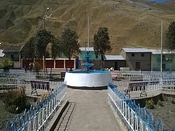
The main square of Pachapaqui
Coordinates: Coordinates: 9°57′45″S77°05′51″W / 9.9626°S 77.0976°W / -9.9626; -77.0976
CountryFlag of Peru.svg  Peru
Region Ancash
Province Bolognesi
District Aquia
CapitalPachapaqui
Area
  Total326.5 km2 (126.1 sq mi)
Elevation
3,800 m (12,500 ft)
Population
  Total1,000
  Density3.1/km2 (7.9/sq mi)
Time zone UTC-5 (PET)
UBIGEO 020504

Pachapaqui is a village in the north of Aquia District in the Bolognesi Province of the Ancash Region, Peru. It has about a thousand inhabitants, mostly engaged in raising cattle and sheep, and small-scale agriculture.

Contents

Geography

The stadium Estadio Municipal de Pachapaqui.jpg
The stadium
Yanaqucha ("black lake") at the foot of Jupa Tawqana Laguna Yanacocha.jpg
Yanaqucha ("black lake") at the foot of Jupa Tawqaña

Location

It is located at 3,800 m on a platform of uniform relief, on the western side of the Pativilca River. The distance to Lima is 350 km, to Huaraz in the Callejón de Huaylas 80 km and to Barranca 160 km.

Climate

Due to its altitude it is located in the Suni or Jalca region according to Javier Pulgar Vidal. The climate is mild and cold with annual temperature of 12 °C, dry during the months of May to October, precipitation from October to April. There may be some frost in June July and August. The rainy season is from December to March. It is characterized by heavy rainfall and occurrences of fog that can stay in the valleys all day long. There is frost in the months from July to September. The rest of the year is dry with mostly sunny days. However, in July and August there may be short rains and clouds.

Language

Fifty years ago, the main language was Quechua, different forms of Ancash Quechua. Now the dominant language is Castilian while Quechua is spoken almost entirely by the elderly due to the recent influx of new residents from the coast who speak only Spanish.

Tourism

Communication channels

Pachapaqui can be reached as follows:

Related Research Articles

<span class="mw-page-title-main">Department of Ancash</span> Departments of Peru

Ancash is a department and region in western Peru. It is bordered by the departments of La Libertad on the north, Huánuco and Pasco on the east, Lima on the south, and the Pacific Ocean on the west. Its capital is the city of Huaraz, and its largest city and port is Chimbote. The name of the region originates from the Quechua word anqash, from anqas ('blue') or from anka ('eagle').

<span class="mw-page-title-main">Department of Huancavelica</span> Departments of Peru

Huancavelica is a department and region in Peru with an area of 22,131.47 km2 (8,545.01 sq mi) and a population of 347,639. The capital is the city Huancavelica. The region is bordered by the departments of Lima and Ica in the west, Junín in the north, and Ayacucho in the east.

<span class="mw-page-title-main">Cordillera Huayhuash</span> Mountain range in the Andes of Peru

Huayhuash is a mountain range within the Andes of Peru, in the boundaries of the regions of Ancash, Lima and Huánuco. Since 2002 it is protected within the Cordillera Huayhuash Reserved Zone.

<span class="mw-page-title-main">Huaraz</span> City in Ancash, Peru

Huaraz, founded as San Sebastián de Huaraz, is a city in Peru. It is the capital of the Ancash Region and the seat of government of Huaraz Province. The urban area's population is distributed over the districts of Huaraz and Independencia. The city is located in the middle of the Callejon de Huaylas valley and on the right side of the Santa river. The city has an elevation of approximately 3050 metres above sea level. The built-up area covers 8 km2 and has a population of 120,000 inhabitants, making it the second largest city in the central Peruvian Andes after the city of Huancayo. It is the 22nd largest city in Peru. Huaraz is the seat of the province's Roman Catholic Bishop and the site of the cathedral.

The Santa Valley is an inter-andean valley in the Ancash Region in the north-central highlands of Peru. Due to its location between two mountain ranges, it is known as Callejón de Huaylas, the Alley of Huaylas, whereas "Huaylas" refers to the territorial division's name during the Viceroyalty of Peru.

<span class="mw-page-title-main">Santa River</span> River in Peru

The Santa River is a river in the South American Andes mountain range in the Ancash Region of northwest central Peru.

<span class="mw-page-title-main">Lake Conococha</span> Body of water

Lake Conococha is a South American lake located in the Andes mountains of northwestern Peru. It is located in the region of Ancash near the junction of the roads going from Callejón de Huaylas to Chiquián.

<span class="mw-page-title-main">Caraz</span> Town in Ancash, Peru

Caraz is a town in the Caraz District in the southeastern part of Huaylas Province of the Ancash Region in Peru.

<span class="mw-page-title-main">Asunción Province</span> Province in Ancash, Peru

Asunción Province is one of the 20 provinces of the Ancash Region in Peru, one of the smallest provinces of the region. It is located in the heart of the central highlands of the region, on the eastern slopes of the Cordillera Blanca, in the eastern area of the Ancash Region at a distance of 121 km from the city of Huaraz, the capital of the region, and 521 km from the city of Lima, the capital of Peru. Chacas, the capital of the province, is located about 3,350 m high in the midst of extremely rugged terrain.

<span class="mw-page-title-main">Huaraz Province</span> Province in Ancash, Peru

The Huaraz Province is one of twenty provinces of the Ancash Region in Peru. It was created on August 5, 1857 during the presidency of Ramón Castilla. Geographically, the province is located over the Callejón de Huaylas and the western slopes of the Cordillera Negra.

<span class="mw-page-title-main">Caraz District</span> District in Ancash, Peru

The Caraz District is one of 10 districts of the Huaylas Province in the Ancash Region of Peru. The capital of the district is Caraz. Its elevation is 2,285 m. In Caraz, the paved road comes from Pativilca.

<span class="mw-page-title-main">Yuracmarca District</span> District in Ancash, Peru

Yuracmarca or Yuraq Marka is one of 10 districts of the Huaylas Province in the Ancash Region of Peru. The capital of the district is the village of Yuracmarca.

Recuay is a town in the Ancash Region, Peru. It is located at the border of the Santa River, 3422 msnm, and it the capital of the Recuay Province. it was created by law 11326 on April 14, 1950.

<span class="mw-page-title-main">La Unión, Huánuco</span> Village in Huánuco, Peru

La Unión is a town in central Peru, capital of the province Dos de Mayo in the region Huánuco. The city is over the Vizcarra river and has two districts, Aguamiro on the right bank and Ripán on the left bank. It has a regional hospital. Close to the city, over a flat highland or meseta is the old famed Inca city called Wanuku Pampa, Wanuku Marka or Wanuku Viejo. The most important festival is by the end of July and it is called "La Fiesta del Sol".

Challhuacocha is a lake in Peru located in the Ancash Region, Pallasca Province, Conchucos District. It lies southeast of Lake Pelagatos, northwest of the lake named Labrascocha (possibly from Quechua Lawrasqucha) and north of the village of Challuacocha (possibly from Quechua Challwaqucha). It is situated at a height of 3,878 m (12,723 ft) comprising an area of 0.460868 km2 (460,868 m2).

<span class="mw-page-title-main">Taullicocha (Ancash)</span> Body of water

Taullicocha or Tawlliqucha is a lake in the Cordillera Blanca in the Andes of Peru located in the Ancash Region, Huaylas Province, Santa Cruz District. It is situated at a height of 4,426 m (14,521 ft) comprising an area of 0.133766 km2 (133,766 m2). Taullicocha lies southeast of Pucajirca and southwest of Taulliraju.

<span class="mw-page-title-main">Rúrec</span> Mountain in Peru

Rúrec, also spelled Rurec, is a 5,700-metre-high (18,701 ft) mountain in the southern part of the Cordillera Blanca in the Andes of Peru. It is located in the Ancash Region, Huaraz Province, Olleros District, and in the Huari Province, Chavín de Huantar District. Rúrec is located south of Huantsán.

<span class="mw-page-title-main">Calapo</span> Mountain in Peru

Calapo or Kallapu is a mountain in the Huallanca mountain range in the Andes of Peru which reaches an altitude of approximately 4,800 m (15,700 ft). It is located in the Ancash Region, Bolognesi Province, Aquia District, east of the town of Pachapaqui.

<span class="mw-page-title-main">Pampas Grande</span> Village in Ancash, Peru

Pampas Grande, founded as San Jerónimo de Pampas, It is a Peruvian town, capital of the homonymous district, located in the central part of the so-called Callejón de Huaylas in the Ancash region, about 4 hours from Huaraz and 9 from Lima. It has an approximate population of 1044 inhabitants, located at an average altitude of 3690 m a.s.l. It has a cold climate with average temperatures of 17 °C in summer and 12 °C in winter.

<span class="mw-page-title-main">Pedro Pablo Atusparía</span> Peruvian-Quechuan military leader (1840–1887)

Pedro Pablo Atusparía Ángeles was a Peruvian politician and indigenous rights activist of Quechua descent. He was known for initially organizing the Huaraz Rebellion before being rehabilitated by the new government of Andrés Avelino Cáceres as part of the larger Peruvian Civil War of 1884–1885.