
Oceania is a geographical region that includes Australasia, Melanesia, Micronesia, and Polynesia. Spanning the Eastern and Western hemispheres, Oceania is estimated to have a land area of 8,525,989 square kilometres (3,291,903 sq mi) and a population of around 44.5 million as of 2021. When compared with the continents, the region of Oceania is the smallest in land area and the second least populated after Antarctica. Its major population centres are Sydney, Melbourne, Brisbane, Perth, Auckland, Adelaide, Honolulu, and Christchurch.

The Pacific Ocean is the largest and deepest of Earth's five oceanic divisions. It extends from the Arctic Ocean in the north to the Southern Ocean in the south, and is bounded by the continents of Asia and Oceania in the west and the Americas in the east.

The Ring of Fire is a region around much of the rim of the Pacific Ocean where many volcanic eruptions and earthquakes occur. The Ring of Fire is a horseshoe-shaped belt about 40,000 km (25,000 mi) long and up to about 500 km (310 mi) wide.

The National Hurricane Center (NHC) is the division of the United States' NOAA/National Weather Service responsible for tracking and predicting tropical weather systems between the Prime Meridian and the 140th meridian west poleward to the 30th parallel north in the northeast Pacific Ocean and the 31st parallel north in the northern Atlantic Ocean. The agency, which is co-located with the Miami branch of the National Weather Service, is situated on the campus of Florida International University in Westchester, Florida.

El Niño–Southern Oscillation (ENSO) is an irregular periodic variation in winds and sea surface temperatures over the tropical eastern Pacific Ocean, affecting the climate of much of the tropics and subtropics. The warming phase of the sea temperature is known as El Niño and the cooling phase as La Niña. The Southern Oscillation is the accompanying atmospheric component, coupled with the sea temperature change: El Niño is accompanied by high air surface pressure in the tropical western Pacific and La Niña with low air surface pressure there. The two periods last several months each and typically occur every few years with varying intensity per period.

The Indo-Pacific is a vast biogeographic region of Earth.

An ocean current is a continuous, directed movement of sea water generated by a number of forces acting upon the water, including wind, the Coriolis effect, breaking waves, cabbeling, and temperature and salinity differences. Depth contours, shoreline configurations, and interactions with other currents influence a current's direction and strength. Ocean currents are primarily horizontal water movements.

Tropical cyclones and subtropical cyclones are named by various warning centers to simplify communication between forecasters and the general public regarding forecasts, watches and warnings. The names are intended to reduce confusion in the event of concurrent storms in the same basin. Once storms develop sustained wind speeds of more than 33 knots, names are generally assigned to them from predetermined lists, depending on the basin in which they originate. Some tropical depressions are named in the Western Pacific; while tropical cyclones must contain a significant amount of gale-force winds before they are named in the Southern Hemisphere.
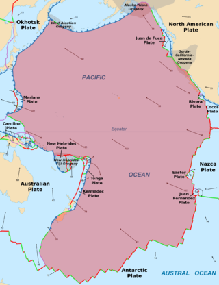
The Pacific Plate is an oceanic tectonic plate that lies beneath the Pacific Ocean. At 103 million km2 (40 million sq mi), it is the largest tectonic plate.

In oceanography, a gyre is any large system of circulating ocean currents, particularly those involved with large wind movements. Gyres are caused by the Coriolis effect; planetary vorticity, horizontal friction and vertical friction determine the circulatory patterns from the wind stress curl (torque).

Asia-Pacific (APAC) is the part of the world near the western Pacific Ocean. The Asia-Pacific region varies in area depending on context, but it generally includes countries in East Asia, Southeast Asia, and Oceania that border the Pacific Ocean. Afghanistan, the Indian subcontinent, Mongolia, Myanmar, and the Russian Far East may be included in a wider Asia-Pacific region.

A mid-ocean ridge (MOR) is a seafloor mountain system formed by plate tectonics. It typically has a depth of about 2,600 meters (8,500 ft) and rises about 2,000 meters (6,600 ft) above the deepest portion of an ocean basin. This feature is where seafloor spreading takes place along a divergent plate boundary. The rate of seafloor spreading determines the morphology of the crest of the mid-ocean ridge and its width in an ocean basin.

The Great Pacific garbage patch is a garbage patch, a gyre of marine debris particles, in the central North Pacific Ocean. It is located roughly from 135°W to 155°W and 35°N to 42°N. The collection of plastic and floating trash originates from the Pacific Rim, including countries in Asia, North America, and South America.

The Southern Oceanic languages are a linkage of Oceanic languages spoken in Vanuatu and New Caledonia. It was proposed by Lynch, Ross, and Crowley in 2002 and supported by later studies. They consider it to be a linkage rather than a language group with a clearly defined internal nested structure.

The Pacific Ocean theater of World War II was a major theater of the Pacific War, the war between the Allies and the Empire of Japan. It was defined by the Allied powers' Pacific Ocean Area command, which included most of the Pacific Ocean and its islands, while mainland Asia was excluded, as were the Philippines, the Dutch East Indies, Borneo, Australia, most of the Territory of New Guinea, and the western part of the Solomon Islands.
The 5th parallel north is a circle of latitude that is 5 degrees north of the Earth's equatorial plane. It crosses the Atlantic Ocean, Africa, the Indian Ocean, Southeast Asia, the Pacific Ocean, and South America.
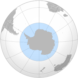
The Southern Ocean, also known as the Antarctic Ocean, comprises the southernmost waters of the World Ocean, generally taken to be south of 60° S latitude and encircling Antarctica. With a size of 20,327,000 km2 (7,848,000 sq mi), it is regarded as the second-smallest of the five principal oceanic divisions: smaller than the Pacific, Atlantic, and Indian oceans but larger than the Arctic Ocean. Over the past 30 years, the Southern Ocean has been subject to rapid climate change, which has led to changes in the marine ecosystem.

The Ocean ships were a class of sixty cargo ships built in the United States by Todd Shipyards Corporation during the Second World War for the British Ministry of War Transport under contracts let by the British Purchasing Commission. Eighteen were lost to enemy action and eight to accidents; survivors were sold postwar into merchant service.
