
The Orinoco River is one of the longest rivers in South America at 2,140 kilometres (1,330 mi). Its drainage basin, sometimes known as the Orinoquia, covers 880,000 km2 (340,000 sq mi), with 76.3 percent of it in Venezuela and the remainder in Colombia. It is the third largest river in the world by discharge volume of water. The Orinoco River and its tributaries are the major transportation system for eastern and interior Venezuela and the llanos of Colombia. The environment in the Orinoco's basin is extremely diverse; it hosts a wide variety of flora and fauna.

Herndon, formerly Trevorton Junction, is a borough in Northumberland County, Pennsylvania, United States. Herndon was first founded by Robert A. Parrish in 1840. The town was later named for Naval commander William Lewis Herndon, who died in 1857 while trying to rescue passengers from his sinking ship. The population was 324 at the 2010 census.
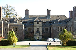
Llangoed Hall is a country house hotel, near the village of Llyswen, in Powys, Mid Wales. It is known for its decoration in Laura Ashley fabrics and styles, and was owned by Sir Bernard Ashley, the widower of the designer. It is a Grade II* listed building.
The City Hall Square Building was a 79-meter (259 ft) tall building located on North Clark Street in Chicago, Illinois, United States. It was completed in 1912 however was destroyed and replaced in 1965 by the Richard J. Daley Center.

Garden Hill is the second largest of 3 reserves of the Island Lake region. The First Nation community is located in the northeast section of the Canadian province of Manitoba on the shore of Island Lake. Garden Hill had a population of 2,776 in the Canada Census of 2011. The residents of Garden Hill speak Oji-Cree, the traditional First Nations language, and English.
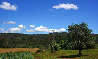
Irixoa is a municipality of northwestern Spain in the province of A Coruña, in the autonomous community of Galicia. It belongs to the comarca of Betanzos. Irixoa has a population of 1,502 inhabitants.

La Tortuga Island is an uninhabited island of Venezuela, the largest in the Federal Dependencies of Venezuela. It is part of a group of islands that include the Tortuguillos and Cayo Herradura. Isla La Tortuga has an area of 156 km2 (60 sq mi).
The Deer River is a 2.6-mile (4.2 km) long stream in eastern New Hampshire in the United States. It is a tributary of Silver Lake, part of the Ossipee Lake / Saco River watershed leading to the Atlantic Ocean.

Dubicsány is a village in Borsod-Abaúj-Zemplén County, in Hungary.
Cuchivero River is a river of Venezuela. It is part of the Orinoco River basin.
Matacuni River is a river of Venezuela. It is part of the Orinoco River basin.
Ocamo River is a river of Venezuela. It is part of the Orinoco River basin.
Mavaca River is a river of Venezuela. It is part of the Orinoco River basin.
Manaviche River is a river of Venezuela. It is part of the Orinoco River basin.

The Unare River is a river of Venezuela. It drains into the Caribbean Sea. In the 17th century the Dutch had a fort at the mouth of the river. It was constructed to protect their salt collection in the area. The other Dutch fort ever to stand on what is now Venezuelan soil stood on the little uninhabited islet La Tortuga, just west of Isla Margarita. It was built for the same reason as the one in Unare: to protect the salt harvesting activities of the Dutch. The Caribbean islands St. Maarten and Bonaire would subsequently satisfy the Dutch demand for salt.

The Claro River is a river of Chile located in the Maule Region. It rises in the Andes, in the Radal Siete Tazas National Park and flows northwest until the city of Molina. Then, it flows southwest, crosses below the Panamericana, to the vicinity of the city of Talca to empty into the Maule River. In this last portion of its course, the river receives the waters of the tributary Lircay River.

Bishopstown Community School was established in Bishopstown in 1979. It was, and still is, the only co-educational secondary school in the Bishopstown area.
Eureka Creek is a tributary of Baker Creek in the U.S. state of Alaska. Other Baker tributaries in the vicinity of Eureka Creek include Thanksgiving, Gold Run, and Pioneer creeks with Seattle Junior Creek a tributary of Pioneer.
Peno Township is an inactive township in Pike County, in the U.S. state of Missouri.

