
A dissected plateau is a plateau area that has been severely eroded so that the relief is sharp. Such an area may be referred to as mountainous, but dissected plateaus are distinguishable from orogenic mountain belts by the lack of folding, metamorphism, extensive faulting, or magmatic activity that accompanies orogeny.
The Coronado National Forest is a United States National Forest that includes an area of about 1.78 million acres (7,200 km2) spread throughout mountain ranges in southeastern Arizona and southwestern New Mexico.

The Jemez Mountains ([ˡhɛmɛz]) are a volcanic group of mountains in Rio Arriba, Sandoval, and Los Alamos counties, New Mexico, United States.
The Pajarito Plateau is a volcanic plateau in north central New Mexico, United States. The plateau, part of the Jemez Mountains, is bounded on the west by the Valles Caldera and on the east by the White Rock Canyon of the Rio Grande. The plateau is occupied by several notable entities, including Bandelier National Monument, the town of Los Alamos and its remote suburb White Rock, and Los Alamos National Laboratory. Elevations range from about 5600 feet at the river to about 7800 feet where the plateau merges into the mountain range.

Pajarito Mountain Ski Area (Pajarito) is located on the north face of Pajarito Mountain, one of the Jemez Mountains in north central New Mexico, west of Los Alamos. It is located on 850 acres (3.4 km2) of privately owned land. Pajarito Mountain is owned and operated by volunteers and Mountain Capital Partners. A typical season runs from Christmas to early April, but an outstanding season may run from Thanksgiving to late April. Pajarito now has a snowmaking system and it is producing snow. Season passes are available with discounts available for early season purchase.

The La Mesa Fire was a 1977 wildfire on the Pajarito Plateau of New Mexico, in the Southwestern United States.
Ricardo Moreno Escamilla was a Mexican professional boxer in the Super Featherweight division. Moreno was ranked #76 on The Ring's list of 100 All time Greatest Punchers.
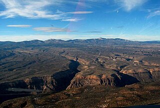
Caja del Rio is a dissected plateau, of volcanic origin, which covers approximately 84,000 acres of land in northern Santa Fe County, New Mexico, United States. The region is also known as the Caja, Caja del Rio Plateau, and Cerros del Rio. The center of the area is approximately 15 miles (23 km) west of Santa Fe, New Mexico. Most of the Caja is owned by the United States Forest Service and managed by the Santa Fe National Forest. Access is through New Mexico Highway 599, Santa Fe County Road 62, and Forest Service Road 24.

Los Alamos is a town in Los Alamos County, New Mexico, United States that is recognized as the development and creation place of the atomic bomb—the primary objective of the Manhattan Project by Los Alamos National Laboratory during World War II. The town is located on four mesas of the Pajarito Plateau, and has a population of 12,019. It is the county seat and one of two population centers in the county known as census-designated places (CDPs); the other is White Rock.

The Atascosa Mountains is a mountain range in western Santa Cruz County, Arizona, United States. It is sandwiched between the larger Tumacacori Mountains to the north, and a small east–west border range to the south, the Pajarito Mountains; the Pajaritos are on the U.S.-Mexico border and abut the Sierra La Esmeralda range in northern Sonora.

The San Luis Mountains are a small, lower elevation mountain range of central-southern Pima County Arizona adjacent to the U.S.-Mexico border, northeast of Sasabe, Arizona–Sasabe, Sonora.
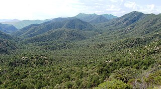
The Pajarito Mountains ia a small mountain range of western Santa Cruz County, Arizona, United States, that extend south into Sonora, Mexico. The range is adjacent the Atascosa Mountains at its north, with both ranges in the center of a north-south sequence of ranges called the Tumacacori Highlands. The Highlands have the Tumacacori Mountains at the north, and south of the U.S.-Mexico border, the Sierra La Esmeralda range,. The Tumacacori Highlands are part of a regional conservancy study of 'travel corridors' for cats, called Cuatro Gatos, Four Cats, for mountain lions, ocelot, bobcat, and jaguar.
The Las Guijas Mountains are a small northwest - southeast trending mountain range in southern Pima County, Arizona. The range is approximately 12 kilometres (7.5 mi) long by 4 km (2.5 mi). Surrounding ranges includes the Cerro Colorado Mountains to the northeast, the Tumacacori Mountains of Santa Cruz County to the east, the San Luis Mountains to the south and the Baboquivari Mountains across the Altar Valley to the west. Arivaca is immediately to the southeast and the old mining townsite of Las Guijas is in the wash just north of the range.
Pajarito Mesa is a census-designated place in Bernalillo County, New Mexico, United States. At the 2010 census, the population was 579. It is part of the Albuquerque Metropolitan Statistical Area.

The Pajarito Mountains are a small mountain range at the southern end of the Sierra Madre Occidental. They are located in the state of Nayarit in western Mexico.
The Pajarito Mountains are a small mountain range in the Sierra Madre Occidental. They are located in the state of Sonora in northwestern Mexico.

The Tumacacori Mountains is a mountain range in Santa Cruz and Pima counties in southern Arizona, United States. The highest peak in the range is an unnamed summit with an elevation of 5,736 feet (1,748 m).