
Seafloor spreading is a process that occurs at mid-ocean ridges, where new oceanic crust is formed through volcanic activity and then gradually moves away from the ridge.

Subduction is a geological process that takes place at convergent boundaries of tectonic plates where one plate moves under another and is forced to sink due to gravity into the mantle. Regions where this process occurs are known as subduction zones. Rates of subduction are typically in centimeters per year, with the average rate of convergence being approximately two to eight centimeters per year along most plate boundaries.

In plate tectonics, a divergent boundary or divergent plate boundary is a linear feature that exists between two tectonic plates that are moving away from each other. Divergent boundaries within continents initially produce rifts which eventually become rift valleys. Most active divergent plate boundaries occur between oceanic plates and exist as mid-oceanic ridges. Divergent boundaries also form volcanic islands which occur when the plates move apart to produce gaps which molten lava rises to fill.

A mantle plume is a proposed mechanism of convection of abnormally hot rock within the Earth's mantle. Because the plume head partly melts on reaching shallow depths, a plume is often invoked as the cause of volcanic hotspots, such as Hawaii or Iceland, and large igneous provinces such as the Deccan and Siberian traps. Some such volcanic regions lie far from tectonic plate boundaries, while others represent unusually large-volume volcanism near plate boundaries or in large igneous provinces.

A magma chamber is a large pool of liquid rock beneath the surface of the Earth. The molten rock, or magma, in such a chamber is under great pressure, and, given enough time, that pressure can gradually fracture the rock around it, creating a way for the magma to move upward. If it finds its way to the surface, then the result will be a volcanic eruption; consequently, many volcanoes are situated over magma chambers. These chambers are hard to detect deep within the Earth, and therefore most of those known are close to the surface, commonly between 1 km and 10 km down.
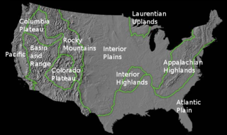
The richly textured landscape of the United States is a product of the dueling forces of plate tectonics, weathering and erosion. Over the 4.5 billion-year history of our Earth, tectonic upheavals and colliding plates have raised great mountain ranges while the forces of erosion and weathering worked to tear them down. Even after many millions of years, records of Earth's great upheavals remain imprinted as textural variations and surface patterns that define distinctive landscapes or provinces.

A mid-ocean ridge (MOR) is a seafloor mountain system formed by plate tectonics. It typically has a depth of ~2,500 meters and rises about two kilometers above the deepest portion of an ocean basin. This feature is where seafloor spreading takes place at a divergent plate boundary. The rate of seafloor spreading determines the morphology of the crest of the mid-ocean ridge and its width in an ocean basin. The production of new seafloor and oceanic lithosphere results from mantle upwelling in response to plate separation; the isentropic upwelling solid mantle material exceeds the solidus temperature and melts. The melt rises as magma at the linear weakness in the oceanic crust, and emerges as lava, creating new crust and lithosphere upon cooling. The Mid-Atlantic Ridge is a spreading center that bisects the North and South Atlantic basins; hence the origin of the name 'mid-ocean ridge'. Most oceanic spreading centers are not in the middle of their hosting ocean basis but regardless, are called mid-ocean ridges. Mid-ocean ridges around the globe are linked by plate tectonic boundaries to appear like the seam of a baseball. The mid-ocean ridge system thus comprises the longest mountain range on Earth, reaching about 65,000 km.
The Iceland plume is a postulated upwelling of anomalously hot rock in the Earth's mantle beneath Iceland. Its origin is thought to lie deep in the mantle, perhaps at the boundary between the core and the mantle at approximately 2,880 km depth. Opinions differ as to whether seismic studies have imaged such a structure. In this framework, the volcanism of Iceland is attributed to this plume, according to the theory of W. Jason Morgan.

Cleopatra, initially called Cleopatra Patera, is an impact crater on Venus, in Maxwell Montes.
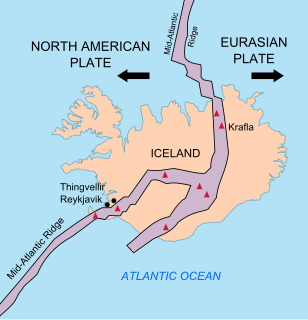
The geology of Iceland is unique and of particular interest to geologists. Iceland lies on the divergent boundary between the Eurasian plate and the North American plate. It also lies above a hotspot, the Iceland plume. The plume is believed to have caused the formation of Iceland itself, the island first appearing over the ocean surface about 16 to 18 million years ago. The result is an island characterized by repeated volcanism and geothermal phenomena such as geysers.
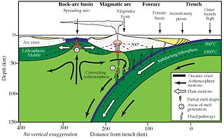
Back-arc basins are geologic basins, submarine features associated with island arcs and subduction zones. They are found at some convergent plate boundaries, presently concentrated in the western Pacific Ocean. Most of them result from tensional forces caused by oceanic trench rollback and the collapse of the edge of the continent. The arc crust is under extension or rifting as a result of the sinking of the subducting slab. Back-arc basins were initially a surprising result for plate tectonics theorists, who expected convergent boundaries to be zones of compression, rather than major extension. However, they are now recognized as consistent with this model in explaining how the interior of Earth loses heat.
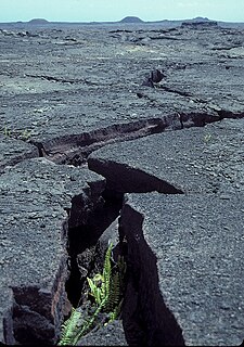
A rift zone is a feature of some volcanoes, especially shield volcanoes, in which a set of linear cracks develops in a volcanic edifice, typically forming into two or three well-defined regions along the flanks of the vent. Believed to be primarily caused by internal and gravitational stresses generated by magma emplacement within and across various regions of the volcano, rift zones allow the intrusion of magmatic dykes into the slopes of the volcano itself. The addition of these magmatic materials usually contributes to the further rifting of the slope, in addition to generating fissure eruptions from those dykes that reach the surface. It is the grouping of these fissures, and the dykes that feed them, that serves to delineate where and whether a rift zone is to be defined. The accumulated lava of repeated eruptions from rift zones along with the endogenous growth created by magma intrusions causes these volcanoes to have an elongated shape. Perhaps the best example of this is Mauna Loa, which in Hawaiian means "long mountain", and which features two very well defined rift zones extending tens of kilometers outward from the central vent.

The interaction between erosion and tectonics has been a topic of debate since the early 1990s. While the tectonic effects on surface processes such as erosion have long been recognized, the opposite has only recently been addressed. The primary questions surrounding this topic are what types of interactions exist between erosion and tectonics and what are the implications of these interactions. While this is still a matter of debate, one thing is clear, the Earth's landscape is a product of two factors: tectonics, which can create topography and maintain relief through surface and rock uplift, and climate, which mediates the erosional processes that wear away upland areas over time. The interaction of these processes can form, modify, or destroy geomorphic features on the Earth's surface.
Volcanic passive margins (VPM) and non-volcanic passive margins are the two forms of transitional crust that lie beneath passive continental margins that occur on Earth as the result of the formation of ocean basins via continental rifting. Initiation of igneous processes associated with volcanic passive margins occurs before and/or during the rifting process depending on the cause of rifting. There are two accepted models for VPM formation: hotspots/mantle plumes and slab pull. Both result in large, quick lava flows over a relatively short period of geologic time. VPM's progress further as cooling and subsidence begins as the margins give way to formation of normal oceanic crust from the widening rifts.
Guðmundur or Gudmundur is an Icelandic male first name, sometimes shortened to Gummi or Gvendur.
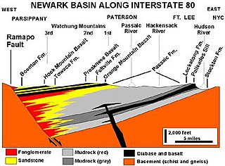
A half-graben is a geological structure bounded by a fault along one side of its boundaries, unlike a full graben where a depressed block of land is bordered by parallel faults.

The opening of the North Atlantic Ocean is a geological event that occurred over millions of years, during which the supercontinent Pangea broke up. As modern-day Europe and North America separated during the final breakup of Pangea in the early Cenozoic Era, they formed the North Atlantic Ocean. Geologists believe the breakup occurred either due to primary processes of the Iceland plume or secondary processes of lithospheric extension from plate tectonics.
Mountains are widely distributed across the surface of Io, the innermost large moon of Jupiter. There are about 115 named mountains; the average length is 157 km (98 mi) and the average height is 6,300 m (20,700 ft). The longest is 570 km (350 mi), and the highest is Boösaule Montes, at 17,500 metres (57,400 ft), taller than any mountain on Earth. Ionian mountains often appear as large, isolated structures; no global tectonic pattern is evident, unlike on Earth, where plate tectonics is dominant.
The Angola Basin is located along the West African South Atlantic Margin which extends from Cameroon to Angola. It is characterized as a passive margin that began spreading in the south and then continued upwards throughout the basin. This basin formed during the initial breakup of the supercontinent Pangaea during the early Cretaceous, creating the Atlantic Ocean and causing the formation of the Angola, Cape, and Argentine basins. It is often separated into two units: the Lower Congo Basin, which lies in the northern region and the Kwanza Basin which is in the southern part of the Angola margin. The Angola Basin is famous for its "Aptian Salt Basins," a thick layer of evaporites that has influenced topography of the basin since its deposition and acts as an important petroleum reservoir.

The geological deformation of Iceland is the way that the rocks of the island of Iceland are changing due to tectonic forces. The geological deformation explains the location of earthquakes, volcanoes, fissures, and the shape of the island. Iceland is the largest landmass (102,775 km²) situated on an oceanic ridge. It is an elevated plateau of the sea floor, situated at the crossing of the Mid-Atlantic Ridge and the Greenland-Iceland-Faeroe Ridge. It lies along the oceanic divergent plate boundary of North American Plate and Eurasian Plate. The western part of Iceland sits on the North American Plate and the eastern part sits on the Eurasian Plate. The Reykjanes Ridge of the Mid-Atlantic ridge system in this region crosses the island from southwest and connects to the Kolbeinsey Ridge in the northeast.


