
Thasos or Thassos is a Greek island in the North Aegean Sea. It is the northernmost major Greek island, and 12th largest by area.

Lemnos or Limnos is a Greek island in the northern Aegean Sea. Administratively the island forms a separate municipality within the Lemnos regional unit, which is part of the North Aegean region. The principal town of the island and seat of the municipality is Myrina. At 477.583 square kilometres (184.396 sq mi), it is the 8th-largest island of Greece.

The (Northern) Sporades are an archipelago along the east coast of Greece, northeast of the island of Euboea, in the Aegean Sea. They consist of 24 islands, four of which are permanently inhabited: Alonnisos, Skiathos, Skopelos and Skyros. They may also be referred to as the Thessalian Sporades.

The North Aegean Region is one of the thirteen administrative regions of Greece, and the smallest of the thirteen by population. It comprises the islands of the north-eastern Aegean Sea, called the North Aegean islands, except for Thasos and Samothrace, which belong to the Greek region of Eastern Macedonia and Thrace, and Imbros and Tenedos, which belong to Turkey.

Imbros, officially Gökçeada since 29 July 1970, is the largest island of Turkey, located in Çanakkale Province. It is located in the north-northeastern Aegean Sea, at the entrance of Saros Bay, and has the westernmost point of Turkey. Imbros has an area of 279 km2 (108 sq mi) and has some wooded areas.

The Battle of Athos took place on 1–2 July 1807 as a part of the Napoleonic Wars during the Russo-Turkish War of 1806-1812.

The Thracian Sea is the northernmost part of the Aegean Sea. It is bounded by Macedonia and Thrace as well as northwestern Turkey. The entire area of the sea lies north of the 40th parallel. Its length from east to west is from 23°E to about 25.8°E, or from the Strymonian Gulf east to the northernmost part of the Gallipoli peninsula and the width from north to south is about 40.25°N to 41°N, or from the Dardanelles north to the boundary between the Xanthi and the Rhodope regional units. Islands includes Thasos and Samothrace in Greece and Gökçeada in Turkey. In the south, the sea extends to the north coast of the island of Lemnos. The bays and gulfs includes the Ierissian Gulf to the southwest, the Strymonian Gulf where the Strymon River empties, the Kavala Gulf and the Saros Gulf in Turkey. Rivers emptying into this portion of the gulf include the Nestos and the Evros/Meriç. The famous thermal springs are Loutra Eleftheron in Kavala.
Palaiochori may refer to several places in Greece:

Moudros is a town and a former municipality on the island of Lemnos, North Aegean, Greece. Since the 2011 local government reform it is part of the municipality Lemnos, of which it is a municipal unit. It covers the entire eastern peninsula of the island, with a land area of 185.127 km², covering 38.8% of the island's territory. The municipal seat was the town of Moúdros. Its next largest town is Kontopoúli (623). The municipal unit's total population was 3,925 in the 2011 census.

Nea Koutali is a municipal unit on the island of Lemnos, North Aegean, Greece. Located in the south central portion of the island with a land area of 75.735 square kilometres (29.241 sq mi), it accounts for about 15.9% of the island's area, making it the smallest of the four municipal units on Lemnos. The seat of government is the village of Kontias, while its next largest town is Nea Koutali with 442 people. Nea Koutali's total population as of 2011 was 2,526.
Greek dance (choros) is a very old tradition, being referred to by authors such as Plato, Aristotle, Plutarch and Lucian. There are different styles and interpretations from all of the islands and surrounding mainland areas. Each region formed its own choreography and style to fit in with their own ways. For example, island dances have more of a different smooth flow to them, while Pontic dancing closer to the Black Sea, is very sharp. There are over 10,000 traditional dances that come from all regions of Greece. There are also pan-Hellenic dances, which have been adopted throughout the Greek world. These include specifically the Syrtos, Kalamatianos, Pyrrhichios, Ballos and hasapiko.
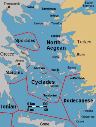
The North Aegean islands are a number of scattered islands in the North Aegean Sea, also known as the Northeastern Aegean islands, belonging mostly to Greece and a few of them to Turkey. The islands do not form a physical chain or group, but are frequently grouped together for tourist or administrative purposes. To the south are the Dodecanese islands; and to the west are the Cyclades and Sporades islands.

Greece is a country of the Balkans, in Southeastern Europe, bordered to the north by Albania, North Macedonia and Bulgaria; to the east by Turkey, and is surrounded to the east by the Aegean Sea, to the south by the Cretan and the Libyan seas, and to the west by the Ionian Sea which separates Greece from Italy.
The Vilayet of the Archipelago was a first-level administrative division (vilayet) of the Ottoman Empire extant from 1867 to 1912–13, including, at its maximum extent, the Ottoman Aegean islands, Cyprus and the Dardanelles Strait.
Falkonera or Gerakoulia (Γερακούλια), anciently known as Hierakia (Ἱεράκια), is a small uninhabited Greek island in the southwestern Aegean Sea, between the island of Milos and the Peloponnese. Although outside the Saronic Gulf, it is generally included among the Saronic Islands. The islet marks the summit of a horst tending WNW-ESE, which separates the Myrtoon basin to the north from the Cretan basin to the south.
An earthquake occurred in the northern Aegean Sea between Greece and Turkey on May 24, 2014. It had a moment magnitude of 6.9 and a maximum Mercalli intensity of VIII (Severe). Serious damage was reported on the Turkish island of Imbros and the cities of Edirne and Çanakkale, as well as on the Greek island of Lemnos. The earthquake was felt in Bulgaria and southern Romania. Several aftershocks followed the main shock, the strongest measuring 5.3 ML. This aftershock struck the Gulf of Saros at 12:31 local time.

Pyrgadikia is a Greek village in the Chalkidiki peninsula. It is located in the south-east part of Chalkidiki, built on the coast of Siggitikos bay. It is part of the Aristotelis municipality and the Panagia municipal unit. The population of the village is 320 residents according to 2011 census. The central church of the village is dedicated to Panagia and celebrated every year on the eight of September.