The PaleozoicEra is the first of three geological eras of the Phanerozoic Eon. Beginning 538.8 million years ago (Ma), it succeeds the Neoproterozoic and ends 251.9 Ma at the start of the Mesozoic Era. The Paleozoic is subdivided into six geologic periods :

In geology, a supercontinent is the assembly of most or all of Earth's continental blocks or cratons to form a single large landmass. However, some geologists use a different definition, "a grouping of formerly dispersed continents", which leaves room for interpretation and is easier to apply to Precambrian times. To separate supercontinents from other groupings, a limit has been proposed in which a continent must include at least about 75% of the continental crust then in existence in order to qualify as a supercontinent.

Laurasia was the more northern of two large landmasses that formed part of the Pangaea supercontinent from around 335 to 175 million years ago (Mya), the other being Gondwana. It separated from Gondwana 215 to 175 Mya during the breakup of Pangaea, drifting farther north after the split and finally broke apart with the opening of the North Atlantic Ocean c. 56 Mya. The name is a portmanteau of Laurentia and Asia.

Pangaea Proxima is a possible future supercontinent configuration. Consistent with the supercontinent cycle, Pangaea Proxima could form within the next 250 million years. This potential configuration, hypothesized by Christopher Scotese in November 1982, earned its name from its similarity to the previous Pangaea supercontinent. Scotese later changed Pangaea Ultima to Pangaea Proxima to alleviate confusion about the name Pangaea Ultima which could imply that it would be the last supercontinent. The concept was suggested by extrapolating past cycles of formation and breakup of supercontinents, not on theoretical understanding of the mechanisms of tectonic change, which are too imprecise to make predictions that far into the future. "It's all pretty much fantasy to start with," Scotese has said. "But it's a fun exercise to think about what might happen. And you can only do it if you have a really clear idea of why things happen in the first place."

Pannotia, also known as the Vendian supercontinent, Greater Gondwana, and the Pan-African supercontinent, was a relatively short-lived Neoproterozoic supercontinent that formed at the end of the Precambrian during the Pan-African orogeny, during the Cryogenian period and broke apart 560 Ma with the opening of the Iapetus Ocean, in the late Ediacaran and early Cambrian. Pannotia formed when Laurentia was located adjacent to the two major South American cratons, Amazonia and Río de la Plata. The opening of the Iapetus Ocean separated Laurentia from Baltica, Amazonia, and Río de la Plata. In 2022 the whole concept of Pannotia has been put into question by scientists who argue its existence is not supported by geochronology, "the supposed landmass had begun to break up well before it was fully assembled".

Siberia, also known as Angaraland and Angarida, is an ancient craton in the heart of Siberia. Today forming the Central Siberian Plateau, it formed an independent landmass prior to its fusion into Pangea during the Late Carboniferous-Permian. The Verkhoyansk Sea, a passive continental margin, was fringing the Siberian Craton to the east in what is now the East Siberian Lowland.
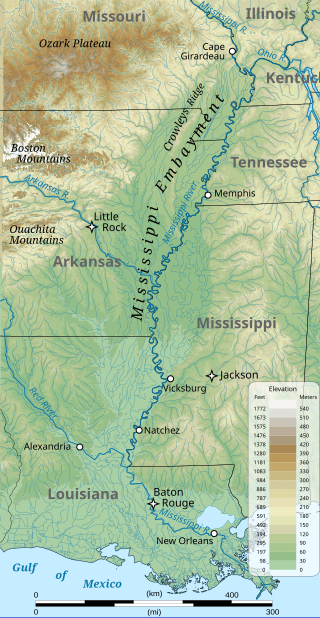
The Mississippi embayment is a physiographic feature in the south-central United States, part of the Mississippi Alluvial Plain. It is essentially a northward continuation of the fluvial sediments of the Mississippi River Delta to its confluence with the Ohio River at Cairo, Illinois. The current sedimentary area was formed in the Cretaceous and early Cenozoic by the filling with sediment of a pre-existing basin. An explanation for the embayment's formation was put forward by Van Arsdale and Cox in 2007: movement of the Earth's crust brought this region over a volcanic "hotspot" in the Earth's mantle causing an upthrust of magma which formed the Appalachian-Ouachita range. Subsequent erosion caused a deep trough that was flooded by the Gulf of Mexico and eventually filled with sediment from the Mississippi River.
A wire is a strand of drawn metal used especially in electrical conductors and fencing.

The Cisuralian is the first series/epoch of the Permian. The Cisuralian was preceded by the Pennsylvanian and followed by the Guadalupian. The Cisuralian Epoch is named after the western slopes of the Ural Mountains in Russia and Kazakhstan and dates between 298.9 ± 0.15 – 272.3 ± 0.5 Ma.
Christopher R. Scotese is an American geologist and paleogeographer. He received his PhD from the University of Chicago in 1985. He is the creator of the Paleomap Project, which aims to map Earth over the last billion years, and is credited with predicting Pangaea Ultima, a possible future supercontinent configuration. Later Scotese changed Pangaea Ultima to Pangaea Proxima to alleviate confusion about the name Pangaea Ultima, which would imply that it would be the last supercontinent.
Gondwana was a supercontinent also known as Gondwanaland.

The geological history of the Earth follows the major geological events in Earth's past based on the geological time scale, a system of chronological measurement based on the study of the planet's rock layers (stratigraphy). Earth formed about 4.54 billion years ago by accretion from the solar nebula, a disk-shaped mass of dust and gas left over from the formation of the Sun, which also created the rest of the Solar System.

Gondwana was a large landmass, sometimes referred to as a supercontinent. It was formed by the accretion of several cratons, beginning c. 800 to 650Ma with the East African Orogeny, the collision of India and Madagascar with East Africa, and was completed c.600 to 530 Ma with the overlapping Brasiliano and Kuunga orogenies, the collision of South America with Africa, and the addition of Australia and Antarctica, respectively. Eventually, Gondwana became the largest piece of continental crust of the Palaeozoic Era, covering an area of about 100,000,000 km2 (39,000,000 sq mi), about one-fifth of the Earth's surface. It fused with Euramerica during the Carboniferous to form Pangea. It began to separate from northern Pangea (Laurasia) during the Triassic, and started to fragment during the Early Jurassic. The final stages of break-up, involving the separation of Antarctica from South America and Australia, occurred during the Paleogene (from around 66 to 23 million years ago. Gondwana was not considered a supercontinent by the earliest definition, since the landmasses of Baltica, Laurentia, and Siberia were separated from it. To differentiate it from the Indian region of the same name, it is also commonly called Gondwanaland.

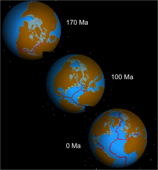
Pangaea or Pangea was a supercontinent that existed during the late Paleozoic and early Mesozoic eras. It assembled from the earlier continental units of Gondwana, Euramerica and Siberia during the Carboniferous approximately 335 million years ago, and began to break apart about 200 million years ago, at the end of the Triassic and beginning of the Jurassic. In contrast to the present Earth and its distribution of continental mass, Pangaea was centred on the equator and surrounded by the superocean Panthalassa and the Paleo-Tethys and subsequent Tethys Oceans. Pangaea is the most recent supercontinent to have existed and the first to be reconstructed by geologists.
A paleocontinent or palaeocontinent is a distinct area of continental crust that existed as a major landmass in the geological past. There have been many different landmasses throughout Earth's time. They range in sizes, some are just a collection of small microcontinents while others are large conglomerates of crust. As time progresses and sea levels rise and fall more crust can be exposed making way for larger landmasses. The continents of the past shaped the evolution of organisms on Earth and contributed to the climate of the globe as well. As landmasses break apart, species are separated and those that were once the same now have evolved to their new climate. The constant movement of these landmasses greatly determines the distribution of organisms on Earth's surface. This is evident with how similar fossils are found on completely separate continents. Also, as continents move, mountain building events (orogenies) occur, causing a shift in the global climate as new rock is exposed and then there is more exposed rock at higher elevations. This causes glacial ice expansion and an overall cooler global climate. The movement of the continents greatly affects the overall dispersal of organisms throughout the world and the trend in climate throughout Earth's history. Examples include Laurentia, Baltica and Avalonia, which collided together during the Caledonian orogeny to form the Old Red Sandstone paleocontinent of Laurussia. Another example includes a collision that occurred during the late Pennsylvanian and early Permian time when there was a collision between the two continents of Tarimsky and Kirghiz-Kazakh. This collision was caused because of their askew convergence when the paleoceanic basin closed.

The Central Pangean Mountains were an extensive northeast–southwest trending mountain range in the central portion of the supercontinent Pangaea during the Carboniferous, Permian and Triassic periods. They were formed as a result of collision between the minor supercontinents Laurussia and Gondwana during the formation of Pangaea. At its greatest elevation during the early part of the Permian period, it was comparable to the present Himalayas. Remnants of this massive mountain range include the Appalachian Mountains and Ouachita Mountains of North America and the Little Atlas of Morocco, Africa.
The opening of the North Atlantic Ocean is a geological event that has occurred over millions of years, during which the supercontinent Pangea broke up. As modern-day Europe and North America separated during the final breakup of Pangea in the early Cenozoic Era, they formed the North Atlantic Ocean. Geologists believe the breakup occurred either due to primary processes of the Iceland plume or secondary processes of lithospheric extension from plate tectonics.
The Pangean megamonsoon refers to the theory that the supercontinent Pangea experienced a distinct seasonal reversal of winds, which resulted in extreme transitions between dry and wet periods throughout the year. Pangea was a conglomeration of all the global continental land masses, which lasted from the late Carboniferous to the mid-Jurassic. The megamonsoon intensified as the continents continued to shift toward one another and reached its maximum strength in the Triassic, when the continental surface area of Pangea was at its peak.

The East Antarctic Shield or Craton is a cratonic rock body that covers 10.2 million square kilometers or roughly 73% of the continent of Antarctica. The shield is almost entirely buried by the East Antarctic Ice Sheet that has an average thickness of 2200 meters but reaches up to 4700 meters in some locations. East Antarctica is separated from West Antarctica by the 100–300 kilometer wide Transantarctic Mountains, which span nearly 3,500 kilometers from the Weddell Sea to the Ross Sea. The East Antarctic Shield is then divided into an extensive central craton that occupies most of the continental interior and various other marginal cratons that are exposed along the coast.