
Karst is a topography formed from the dissolution of soluble carbonate rocks such as limestone and dolomite. It is characterized by features like poljes above and drainage systems with sinkholes and caves underground. There is some evidence that karst may occur in more weathering-resistant rocks such as quartzite given the right conditions.

The Ikara–Flinders Ranges National Park, formerly Flinders Ranges National Park, is a national park situated approximately 430 km (270 mi) north of Adelaide. It lies northeast of the small town of Hawker, in the northern central part of South Australia's largest mountain range, the Flinders Ranges, and covers an area of 95,000 ha (370 sq mi) between Hawker and Blinman. It is known for the land formation known as Wilpena Pound, while other well-known features include the Heysen Range and the Brachina and Bunyeroo gorges. The Heysen Trail and Mawson Trail pass through the park.

A landform is a natural or anthropogenic land feature on the solid surface of the Earth or other planetary body. Landforms together make up a given terrain, and their arrangement in the landscape is known as topography. Landforms include hills, mountains, canyons, and valleys, as well as shoreline features such as bays, peninsulas, and seas, including submerged features such as mid-ocean ridges, volcanoes, and the great ocean basins.

The Jurassic Coast is a World Heritage Site on the English Channel coast of southern England. It stretches from Exmouth in East Devon to Studland Bay in Dorset, a distance of about 96 miles (154 km), and was inscribed on the World Heritage List in mid-December 2001.
Landforms are categorized by characteristic physical attributes such as their creating process, shape, elevation, slope, orientation, rock exposure, and soil type.

Alphonsus is an ancient impact crater on the Moon that dates from the pre-Nectarian era. It is located on the lunar highlands on the eastern end of Mare Nubium, west of the Imbrian Highlands, and slightly overlaps the crater Ptolemaeus to the north. To the southwest is the smaller Alpetragius. The crater name was approved by the IAU in 1935.

A pyramidal peak, sometimes called a glacial horn in extreme cases, is an angular, sharply pointed mountain peak which results from the cirque erosion due to multiple glaciers diverging from a central point. Pyramidal peaks are often examples of nunataks.

A hoodoo is a tall, thin spire of rock formed by erosion. Hoodoos typically consist of relatively soft rock topped by harder, less easily eroded stone that protects each column from the elements. They generally form within sedimentary rock and volcanic rock formations.

Paititi is a legendary Inca lost city or utopian rich land. It allegedly lies east of the Andes, hidden somewhere within the remote rainforests of southeast Peru, northern Bolivia or northwest Brazil. The Paititi legend in Peru revolves around the story of the culture-hero Inkarri, who, after he had founded Q'ero and Cusco, retreated toward the jungles of Pantiacolla to live out the rest of his days in his refuge city of Paititi. Other versions of the legend see Paititi as an Inca refuge in the border area between Bolivia and Brazil.

The Bosnian pyramid claims are pseudoarchaeological theories put forward to explain the formation of a cluster of natural hills in the area of Visoko in central Bosnia and Herzegovina. Since 2005, Semir Osmanagić, a Bosnian-American businessman based in Houston, Texas, has claimed that these hills are the largest human-made ancient pyramids on Earth. His claims have been overwhelmingly refuted by scientists but he has proceeded to promote the area as a tourist attraction.
Mameria is an area of high-elevation jungle to the northeast of the Paucartambo range in southeast Peru, drained by the Mameria River, an affluent of the Nistrón River. Until the 1960s this remote and sparsely populated area would have been considered a part of the Callanga jungle area. Machiguenga peoples, fleeing the slavery that they were subject to along the Yavero River, fled to this area which acquired its current name from the Machiguenga observing that "mameri," which means "there are none," regarding the lack of fish in the river.
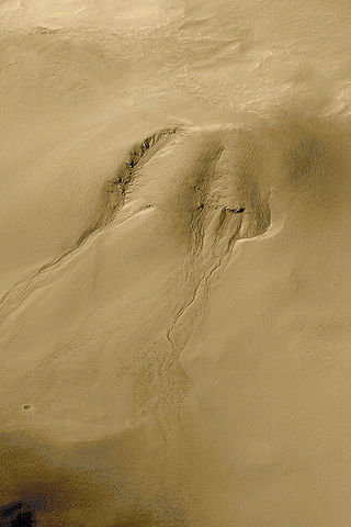
Groundwater sapping is a geomorphic erosion process that results in the headward migration of channels in response to near constant fluid discharge at a fixed point. The consistent flow of water displaces fine sediments which physically and chemically weathers rocks. Valleys that appear to have been created by groundwater sapping occur throughout the world in areas such as England, Colorado, Hawai’i, New Zealand, and many other places. However, it is difficult to characterize a landform as being formed exclusively by groundwater sapping due to phenomena such as pluvial runoff, plunge-pool undercutting, changes in water table level, and inconsistent groundwater flow. An example of drainage ways created purely by the outflow of subsurface fluids can be seen on the foreshores of beaches. As the surge of water and sand brought to land by a wave retreats seaward, the film of water becomes thinner until it forms rhomboid shaped patterns in the sand. Small fans form at the apex of the rhombic features, which are eventually fed by the remaining backflow of water traveling downslope. Channels begin to form headward in the form of millimeter wide rills along the sides of the fans; the creation of these small channel networks culminates when the last of the backwash dissipates.

Sarah Helen Parcak is an American archaeologist and Egyptologist, who has used satellite imagery to identify potential archaeological sites in Egypt, Rome and elsewhere in the former Roman Empire. She is a professor of Anthropology and director of the Laboratory for Global Observation at the University of Alabama at Birmingham. In partnership with her husband, Greg Mumford, she directs survey and excavation projects in the Faiyum, Sinai, and Egypt's East Delta.
Gregory Deyermenjian is a psychologist and explorer. In 1981 he visited the ruins of Vilcabamba la Vieja at Espíritu Pampa, and then turned his attention to the northeast and north of Cusco, Peru. Since the mid-1980s he has made numerous expeditions to Peru investigating Paititi, a legendary lost city that is part of the history and legend of the western Amazon basin. He is a long-term Fellow of The Explorers Club.
The Petroglyphs of Pusharo constitute a unique and extensive ancient rock art archaeological site in southeastern Peru's Manú National Park, an expanse of rain forest that still contains unexplored and little known areas, and for which an official government permit is required for entry.

The following outline is provided as an overview of and topical guide to geography:

Shell rings are archaeological sites with curved shell middens completely or partially surrounding a clear space. The rings were sited next to estuaries that supported large populations of shellfish, usually oysters. Shell rings have been reported in several countries, including Colombia, Peru, Japan, and the southeastern United States. Archaeologists continue to debate the origins and use of shell rings.
South American Explorers, headquartered in Ithaca, New York, was a nonprofit travel, scientific, and educational organization founded in 1977. Its goals were advancing field exploration and research in South and Central America on subjects such as biology, geography, anthropology, and archaeology, and promoting field sports such as mountaineering, rafting, and caving.

Lomas, also called fog oases and mist oases, are areas of fog-watered vegetation in the coastal desert of Peru and northern Chile. About 100 lomas near the Pacific Ocean are identified between 5°S and 30°S latitude, a north–south distance of about 2,800 kilometres (1,700 mi). Lomas range in size from a small vegetated area to more than 40,000 hectares and their flora includes many endemic species. Apart from river valleys and the lomas the coastal desert is almost without vegetation. Scholars have described individual lomas as "an island of vegetation in a virtual ocean of desert."

The Melnik Earth Pyramids are rock formations, known as hoodoos, situated at the foothills of the Pirin mountain range in south-western Bulgaria. They span an area of 17 km2 near the town of Melnik, Blagoevgrad Province. Reaching a height of up to 100 m these sandstone pyramids are shaped in forms, resembling giant mushrooms, ancient towers and obelisks. They were formed primarily due to erosion from rainfall and bedrock wear. The Melnik Earth Pyramids are a geological phenomenon of global importance and were declared a natural landmark in 1960. The rock formations are home to rich flora and fauna heavily influenced by the Mediterranean climate. They are a tourist destination due to the natural environment of the area, the cultural sights of Melnik and the Rozhen Monastery.
