
Rogiet is a village and community in Monmouthshire, south east Wales, between Caldicot and Magor, 8 miles (13 km) west of Chepstow and 11 miles (18 km) east of Newport, which covers an area of 847 hectares (3.27 sq mi). It lies close to the M4 and M48 motorways, and the Second Severn Crossing. It has a railway station named Severn Tunnel Junction.

Mount Druitt is a suburb of Sydney, in the state of New South Wales, Australia. It is located 38 kilometres (24 mi) west of the Sydney central business district, in the local government area of the City of Blacktown, and is part of the Greater Western Sydney region.
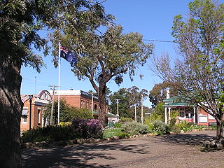
Binalong (Byn-a-long) is a village in the Southern Tablelands of New South Wales, Australia, 37 km north-west of Yass in Yass Valley Shire. At the 2016 census, Binalong and the surrounding area had a population of 543.

Murrumburrah is a township in New South Wales, Australia, part of a twin town with Harden. The town is in Hilltops Council local government area in the South West Slopes area of NSW. It is on the Burley Griffin Way, the major link from the Riverina to the Hume Highway near Yass, and ultimately Sydney, Canberra and the coast. At the 2011 census, Murrumburrah had a population of 479.

Langtree is a rural locality and the site of a discontinued railway station in the central northern part of the Riverina. The railway station was about 8 kilometres north of Goorawin and 22 kilometres south of Hillston.

The Parish of Colo is a parish of the County of Camden in the Southern Highlands region of New South Wales. It is centred on the town of Colo Vale, and includes Aylmerton, Willow Vale, Alpine and Yerrinbool. It also includes the northern parts of Mittagong that are north of the Old Hume Highway. The new Hume Highway runs through the parish from south-west to north-east.
The Parish of Bargo is a parish of the County of Camden in New South Wales. Its seat is the village of Bargo. The Main Southern railway line passes through the parish, including the Bargo station. The Hume Highway also passes through the parish, where it intersects Avon Dam Road, and also by the Pheasants Nest roadhouse.
Nubba is a locality and former railway station on the Main South railway line in New South Wales, Australia, located midway between Wallendbeen and Harden. The station was open between 1882 and 1975 and has now been demolished. At the 2006 census, Nubba had a population of 281 people.
Napier is a locality in the Riverina district of New South Wales, Australia and also a civil parish of Buccleuch County, New South Wales.
The parish of Algalah is an Australian cadastral parish in the NSW county of Narromine. It is located 367km west north west from Sydney approximately midway between Tottenham and Narromine and is in Narromine Shire, at 32°14′54″S147°49′04″E.

Tirrannaville is a locality in the Goulburn Mulwaree Council, New South Wales, Australia. It is located about 11 km south of Goulburn on the road to Braidwood. It was formerly called Terranna, which is the name of the parish covering most of the locality. The northern part of the defined locality, including the small settlement of Tirrannaville and cemetery, is in the parish of Goulburn. At the 2016 census, it had a population of 237. The locality mostly consists of grazing land.

Mount Fairy is a locality in the Queanbeyan–Palerang Regional Council, New South Wales, Australia. It is located to the east of the Bungendore–Tarago road. At the 2016 census, it had a population of 205.
Illalong is a rural locality just off the Burley Griffin Way in south New South Wales.
Tabratong located at 32°14′54″S 147°27′04″ is a cadastral parish of Kennedy County New South Wales.
Biamble is a civil parish of Napier County, New South Wales, that is located at 31°43′54″S 149°19′04″E. The civil parish is roughly equivalent to the rural locality of Neilrex in Warrumbungle Shire Council.
Benolong Parish is a civil parish of Gordon County, New South Wales. a Cadastral divisions of New South Wales.
Gundy Parish is a civil parish of Gordon County, New South Wales. a Cadastral divisions of New South Wales.
Burrawong Parish is a civil parish of Gordon County, New South Wales, a Cadastral divisions of New South Wales.

Buckinbah Parish is a civil parish of Gordon County, New South Wales, a Cadastral divisions of New South Wales.

