Parque Thays

Last updated
Parque Thays.jpg

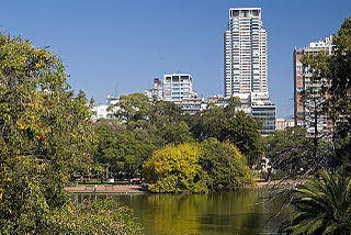
The Parque Thays is a public space in Recoleta, Buenos Aires, Argentina. The park is located in the corners of Libertador avenue y Callao avenue.

Recoleta, Buenos Aires Barrio in Buenos Aires, Argentina

Recoleta is a downtown residential neighborhood in Buenos Aires, Argentina. It is an area of great historical and architectural interest, due to its Beaux-Arts architecture as well as the distinguished Recoleta Cemetery. It is also an important tourist destination in the city.

Buenos Aires Place in Argentina

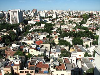
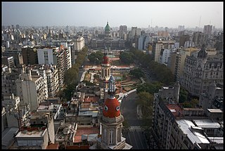
Buenos Aires is the capital and largest city of Argentina. The city is located on the western shore of the estuary of the Río de la Plata, on the South American continent's southeastern coast. "Buenos Aires" can be translated as "fair winds" or "good airs", but the former was the meaning intended by the founders in the 16th century, by the use of the original name "Real de Nuestra Señora Santa María del Buen Ayre". The Greater Buenos Aires conurbation, which also includes several Buenos Aires Province districts, constitutes the fourth-most populous metropolitan area in the Americas, with a population of around 15.6 million.

Argentina federal republic in South America

Argentina, officially the Argentine Republic, is a country located mostly in the southern half of South America. Sharing the bulk of the Southern Cone with Chile to the west, the country is also bordered by Bolivia and Paraguay to the north, Brazil to the northeast, Uruguay and the South Atlantic Ocean to the east, and the Drake Passage to the south. With a mainland area of 2,780,400 km2 (1,073,500 sq mi), Argentina is the eighth-largest country in the world, the fourth largest in the Americas, and the largest Spanish-speaking nation. The sovereign state is subdivided into twenty-three provinces and one autonomous city, Buenos Aires, which is the federal capital of the nation as decided by Congress. The provinces and the capital have their own constitutions, but exist under a federal system. Argentina claims sovereignty over part of Antarctica, the Falkland Islands, and South Georgia and the South Sandwich Islands.

It was named after the French landscape architect Carlos Thays.

Carlos Thays Argentine architect

Carlos Thays was a French-Argentine landscape architect, and a student of French landscape architect Édouard André.

One of the sculptures can be seen in this place is Torso Masculino Desnudo ("Nude Male Torso") by Colombian artist Fernando Botero.

Fernando Botero Colombian artist

Fernando Botero Angulo is a Colombian figurative artist and sculptor. Born in Medellín, his signature style, also known as "Boterismo", depicts people and figures in large, exaggerated volume, which can represent political criticism or humor, depending on the piece. He is considered the most recognized and quoted living artist from Latin America, and his art can be found in highly visible places around the world, such as Park Avenue in New York City and the Champs-Élysées in Paris.

The land on which the park is located is the formerly occupied Italpark amusement park, which was closed in 1990.

Italpark theme park

The Italpark was a theme park in Argentina, which was located where currently is the Parque Thays in the Recoleta neighbourhood of Buenos Aires. It became a landmark of Buenos Aires in its 30 years of existence.

Related Research Articles

Belgrano, Buenos Aires Barrio in Buenos Aires, Argentina

Belgrano is a leafy, northern barrio or neighborhood of the city of Buenos Aires, Argentina.

Palermo, Buenos Aires Barrio in Buenos Aires, Argentina

Palermo is a neighborhood, or barrio of the Argentine capital, Buenos Aires. It is located in the northeast of the city, bordering the barrios of Belgrano to the north, Almagro and Recoleta to the south, Villa Crespo and Colegiales to the west and the Río de la Plata river to the east. With a total area of 17.4 km2 (7 sq mi), Palermo is the largest neighborhood in Buenos Aires. As of 1991 it had a population of 256,927 inhabitants. It is the only barrio within the administrative division of Comuna 14.

Caballito, Buenos Aires Barrio in Buenos Aires, Argentina

Caballito is a barrio (neighborhood) of the Argentine capital, Buenos Aires. It is the only barrio in the administrative division Comuna 6.

Chacarita, Buenos Aires Barrio in Buenos Aires, Argentina

Chacarita is a barrio or neighborhood in the north-central part of Buenos Aires, Argentina. Located between Colegiales, Palermo, Villa Crespo, La Paternal and Villa Ortúzar, this is a quiet neighbourhood with tree-lined streets, a combination of vintage rowhouses and apartment buildings. Locally, it's probably best known for the 95 hectare Chacarita Cemetery.

Parque Tres de Febrero park in Argentina

Parque Tres de Febrero, popularly known as Bosques de Palermo, is an urban park of approximately 400 hectares located in the neighborhood of Palermo in Buenos Aires, Argentina. Located between Libertador and Figueroa Alcorta Avenues, it is known for its groves, lakes, and rose gardens.

Parque Patricios Barrio in Buenos Aires, Argentina

Parque Patricios is a barrio located on the southern side of Buenos Aires, Argentina belonging to the fourth comuna.

Buenos Aires Botanical Garden botanical garden

The Buenos Aires Botanical Garden is a botanical garden located in the Palermo neighborhood of Buenos Aires in Argentina. The garden is triangular in shape, and is bounded by Santa Fe Avenue, Las Heras Avenue and República Árabe Siria Street.

Plaza San Martín (Buenos Aires) square in Buenos Aires, Argentina

Plaza San Martín is a park located in the Retiro neighbourhood of Buenos Aires, Argentina. Situated at the northern end of pedestrianized Florida Street, the park is bounded by Libertador Ave. (N), Maipú St. (W), Santa Fe Avenue (S), and Leandro Alem Av. (E). Its coordinates are 34°35′42″S58°22′32″W.

Avenida Alvear street in Buenos Aires, Argentina

Avenida Alvear is an upscale thoroughfare in Buenos Aires, Argentina. Located in the neighbourhood of Recoleta, it extends for seven blocks, from the Plazoleta Carlos Pellegrini to Alvear Plaza. The avenue is famous not only for the most exclusive representatives of haute couture, but also for its numerous demi-palaces and extensive presence of the French academy architecture that was so much in vogue in uptown Buenos Aires at the turn of the 20th century. The Buenos Aires Legislature approved the bill to declare it as a Historic Protection Area. A study by the U.S. television network NBC, placed it among the world's five most distinguished avenues.

Parque Chacabuco Barrio in Buenos Aires, Argentina

Parque Chacabuco is a neighbourhood in Buenos Aires, Argentina. Its name is due to Chacabuco Park, which is in its centre, taking the name from the Battle of Chacabuco.

Avenida Figueroa Alcorta street in Buenos Aires, Argentina

Avenida Figueroa Alcorta is a major thoroughfare in Buenos Aires, Argentina, with a length of over 7 km (4.3 mi) along the city's northside.

Parque Centenario

Parque Centenario is an extensive public park in the Caballito district of Buenos Aires, Argentina.

Congressional Plaza square in Buenos Aires, Argentina

Congressional Plaza is a public park facing the Argentine Congress in Buenos Aires. The plaza is part of a 3 hectare open space comprising three adjoining plazas to the east of the Congress building. The Kilometre Zero for all Argentine National Highways is marked on a milestone at the Plaza.

Avellaneda Park is a public park in the Parque Avellaneda section of Buenos Aires.

Avenida Callao street in Buenos Aires, Argentina

Avenida Callao is one of the principal thoroughfares in Buenos Aires, Argentina.

Palacio Duhau - Park Hyatt Buenos Aires architectural structure

The Palacio Duhau - Park Hyatt Buenos Aires is a five star establishment located in the city's Recoleta section.

Chacabuco Park

Chacabuco Park is a public park in the Parque Chacabuco section of Buenos Aires.

Bosch Palace

The Bosch Palace is an architecturally significant residence in the Palermo section of Buenos Aires, Argentina.

References

Coordinates: 34°35′04″S58°23′16″W / 34.5844°S 58.3878°W / -34.5844; -58.3878

Geographic coordinate system Coordinate system

A geographic coordinate system is a coordinate system that enables every location on Earth to be specified by a set of numbers, letters or symbols. The coordinates are often chosen such that one of the numbers represents a vertical position and two or three of the numbers represent a horizontal position; alternatively, a geographic position may be expressed in a combined three-dimensional Cartesian vector. A common choice of coordinates is latitude, longitude and elevation. To specify a location on a plane requires a map projection.