
Sucre is the de jure capital city of Bolivia, the capital of the Chuquisaca Department and the sixth most populous city in Bolivia. Located in the south-central part of the country, Sucre lies at an elevation of 2,790 m (9,150 ft). This relatively high altitude gives the city a subtropical highland climate with cool temperatures year-round.

Veracruz, formally Veracruz de Ignacio de la Llave, officially the Estado Libre y Soberano de Veracruz de Ignacio de la Llave, is one of the 31 states which, along with Mexico City, comprise the 32 Federal Entities of Mexico. Located in eastern Mexico, Veracruz is bordered by seven states, which are Tamaulipas, San Luis Potosí, Hidalgo, Puebla, Oaxaca, Chiapas, and Tabasco. Veracruz is divided into 212 municipalities, and its capital city is Xalapa-Enríquez.

Ciudad Juárez, commonly referred to as just Juárez, is the most populous city in the Mexican state of Chihuahua. It was known until 1888 as El Paso del Norte. Juárez is the seat of the Juárez Municipality with an estimated population of 2.5 million people. It lies on the Rio Grande river, south of El Paso, Texas, United States. Together with the surrounding areas, the cities form El Paso–Juárez, the second largest binational metropolitan area on the Mexico–U.S. border, with a combined population of over 3.4 million people.

The Totonac are an indigenous people of Mexico who reside in the states of Veracruz, Puebla, and Hidalgo. They are one of the possible builders of the pre-Columbian city of El Tajín, and further maintained quarters in Teotihuacán. Until the mid-19th century they were the world's main producers of vanilla.
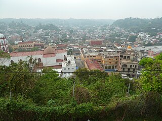
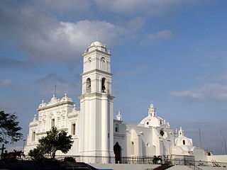
Papantla is a city and municipality located in the north of the Mexican state of Veracruz, in the Sierra Papanteca range and on the Gulf of Mexico. The city was founded in the 13th century by the Totonacs and has dominated the Totonacapan region of the state since then. The region is famed for vanilla, which occurs naturally in this region, the Danza de los Voladores and the El Tajín archeological site, which was named a World Heritage Site. Papantla still has strong communities of Totonacs who maintain the culture and language. The city contains a number of large scale murals and sculptures done by native artist Teodoro Cano García, which honor the Totonac culture. The name Papantla is from Nahuatl and most often interpreted to mean "place of the papanes". This meaning is reflected in the municipality's coat of arms.
Misantla is a city in the Mexican state of Veracruz, the administrative seat of the municipality (municipio) of the same name. The municipality is bordered by Martínez de la Torre, Colipa and Papantla.

Poza Rica, formally: Poza Rica de Hidalgo is a city and its surrounding municipality in the Mexican state of Veracruz. Its name means "rich well/pond". It is often thought that the name came to be because it was a place known for its abundance of oil. In reality, before oil was discovered, there existed a pond rich in fish, which gave origin to the city’s name. In the 20th century oil was discovered in the area. It has since been almost completely extracted. This has resulted in the decline of oil well exploration and drilling activities, though there are still many oil facilities.

The Bilbao metro is a rapid transit system serving the city of Bilbao and the region of Greater Bilbao. Lines 1 and 2 have a "Y" shape, as they transit both banks of the river Ibaizabal and then combine to form one line that ends in the south of Bilbao. Line 3 has a "V" shape connecting the municipality of Etxebarri with the Bilbao neighbourhood of Matiko; the apex of the "V" is Zazpikaleak/Casco Viejo station, where all three current lines meet. The metro is connected with the Bilbao tram, Bilboko Aldiriak, Euskotren Trena, Feve, Renfe long-distance trains, and Bilbao's bus station. All three lines use metre gauge.

Lucena is a municipality of Spain belonging to the province of Córdoba, in the autonomous community of Andalusia.

Totonacapan refers to the historical extension where the Totonac people of Mexico dominated, as well as to a region in the modern states of Veracruz and Puebla. The historical territory was much larger than the currently named region, extending from the Cazones River in the north to the Papaloapan River in the south and then west from the Gulf of Mexico into what is now the Sierra Norte de Puebla region and into parts of Hidalgo. When the Spanish arrived, the Totonac ethnicity dominated this large region, although they themselves were dominated by the Aztec Empire. For this reason, they allied with Hernán Cortés against Tenochtitlán. However, over the colonial period, the Totonac population and territory shrank, especially after 1750 when mestizos began infiltrating Totonacapan, taking political and economic power. This continued into the 19th and 20th centuries, prompting the division of most of historical Totonacpan between the states of Puebla and Veracruz. Today, the term refers only to a region in the north of Veracruz where Totonac culture is still important. This region is home to the El Tajín and Cempoala archeological sites as well as Papantla, which is noted for its performance of the Danza de los Voladores.
The Totonacan languages are a family of closely related languages spoken by approximately 290,000 Totonac and Tepehua people in the states of Veracruz, Puebla, and Hidalgo in Mexico. At the time of the Spanish conquest Totonacan languages were spoken all along the gulf coast of Mexico. During the colonial period, Totonacan languages were occasionally written and at least one grammar was produced. In the 20th century the number of speakers of most varieties have dwindled as indigenous identity increasingly became stigmatized encouraging speakers to adopt Spanish as their main language.
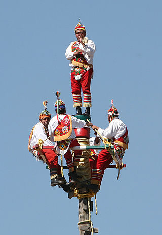
The Danza de los Voladores, or Palo Volador, is an ancient Mesoamerican ceremony/ritual still performed today, albeit in modified form, in isolated pockets in Mexico. It is believed to have originated with the Nahua, Huastec and Otomi peoples in central Mexico, and then spread throughout most of Mesoamerica. The ritual consists of dance and the climbing of a 30-meter pole from which four of the five participants then launch themselves tied with ropes to descend to the ground. The fifth remains on top of the pole, dancing and playing a flute and drum. According to one myth, the ritual was created to ask the gods to end a severe drought. Although the ritual did not originate with the Totonac people, today it is strongly associated with them, especially those in and around Papantla in the Mexican state of Veracruz. The ceremony was named an Intangible cultural heritage by UNESCO in order to help the ritual survive and thrive in the modern world. The Aztecs believed that Danza de los Voladores was the symbol of their culture.
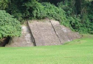
Cuyuxquihui is an archaeological site located in the Tecolutla valley of Veracruz, Mexico, in the region of the Totonac culture, about 22 kilometres (14 mi) southeast of El Tajín or 5 kilometres (3.1 mi) southeast of Paso de Correo.
Bilbao BBK Live is a rock and pop music festival that takes place annually in the city of Bilbao, Spain. Since its beginnings, the festival is held in its entirety on a special complex built specifically for the event on the slopes of Mount Cobetas, located southwest of the city.

Tecolutla is a town and municipality located on the Tecolutla River on the eastern coast of the state of Veracruz in Mexico. It has the closest beaches to Mexico City, and much of its economy is based on tourism, as it is only a four- or five-hour drive from the capital. It is the northern end of a tourist corridor along the Gulf of Mexico called the "Emerald Coast," which extends down to the city of Veracruz.

The Sierra Norte de Puebla is a rugged mountainous region accounting for the northern third of the state of Puebla, Mexico. It is at the intersection of the Trans-Mexican Volcanic Belt and the Sierra Madre Oriental, between the Mexican Plateau and the Gulf of Mexico coast. From the Mesoamerican period to the 19th century, this area was part of a larger region called Totonacapan, and area dominated by the Totonac people, extending further east to the Gulf of Mexico. Political maneuvers to weaken the Totonacs led to the region being divided between the modern states of Puebla and Veracruz with the Puebla section given its current name. Until the 19th century, the area was almost exclusively indigenous, with the four main groups still found here today, Totonacs, Nahuas, Otomis and Tepehuas, but coffee cultivation brought in mestizos and some European immigrants who took over political and economic power. While highly marginalized socioeconomically, the area has been developed heavily since the mid 20th century, especially with the building of roadways linking it to the Mexico City area and the Gulf coast.

Colombia is a country in north-western South America. Colombia is bordered by Venezuela, Brazil, Ecuador, Peru, Panama and the Caribbean Sea and the Pacific Ocean. With a population of over 45 million people, Colombia has the second largest population in South America, after Brazil. The capital is Bogotá.

The Tecolutla River is a river in the state of Veracruz in Mexico, and the main drainage of the historical and cultural region of Totonacapan. It is principally fed by four rivers that rise in the Sierra Norte de Puebla: from north to south, they are the Necaxa, the Lajajalpan, the Tecuantepec and the Apulco. These rivers converge in the municipality of Espinal, Veracruz, and from here the Tecolutla flows about 100 kilometres (62 mi) east through the coastal plain and the municipalities of Papantla and Gutiérrez Zamora to its mouth at the town of Tecolutla on the Gulf of Mexico, On its south bank the Tecolutla receives the Joloapan River near Paso del Correo, and the Chichicatzapan River via the Ostiones estuary near its mouth.
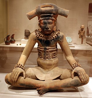
The Totonac culture or Totonec culture was a culture that existed among the indigenous Mesoamerican Totonac people who lived mainly in Veracruz and northern Puebla. Originally, they formed a confederation of cities, but, in later times, it seems that they were organized in three dominions: North, South and Serran. Its economy was agricultural and commercial. They had large urban centers such as: El Tajín (300–1200), which represents the height of the Totonac culture, Papantla (900–1519) and Cempoala (900–1519).

Ricardo Parrondo Gómez, known professionally as Ricardo Gómez, is a Spanish television, film and stage actor. His early success as an actor is intrinsic to his 17-year long performance playing the character of Carlitos Alcántara in the TV series Cuéntame cómo pasó, between 2001 and 2018.
