This page is based on this
Wikipedia article Text is available under the
CC BY-SA 4.0 license; additional terms may apply.
Images, videos and audio are available under their respective licenses.

This article describes the geography of the United States territory of Guam.
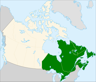
Eastern Canada is generally considered to be the region of Canada east of Manitoba, consisting of the following provinces:
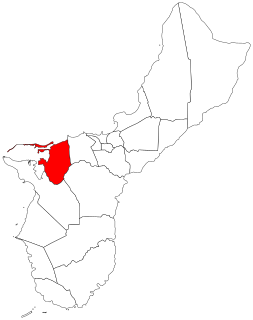
Piti is a village located on the western shore of the United States territory of Guam. It contains the commercial port of Guam at Apra Harbor as well as several of the island’s largest power plants. NAVFAC Marianas is located there.

Bitra, also known as Bitrā Par, is a coral atoll belonging to the Amindivi Subgroup of islands of the Union Territory of Lakshadweep in India.
It is 1,958 km (1,217 mi) south of the city of Delhi.

Duck Island, a small barrier island, lies 1.5 km north of Swan Island and south of Edwards Point in the main entrance to Swan Bay from Port Phillip in southern Victoria, Australia. It is part of the Port Phillip Heads Marine National Park and the plants and animals on and around the island are protected, including the critically endangered orange-bellied parrot. The island is part of the Swan Bay and Port Phillip Bay Islands Important Bird Area, identified as such by BirdLife International.
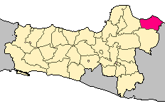
Rembang Regency is a regency on the extreme northeast coast of Central Java Province, on the island of Java at the Java Sea, in Indonesia.

Cabras Island is a long finger of low-lying reef and land which forms the northern shore of Apra Harbor, Guam.

Hiw is the northernmost island in Vanuatu, located in Torba Province.
Facpi Point is a headland in the south-west of the island of Guam. It is three kilometers due west of Mount Lamlam, and five kilometers north of Umatac village. The point was designated a National Natural Landmark in 1972.
Aga Point is the southernmost point on the main island of Guam. It is located between the villages of Merizo and Inarajan. The only parts of Guam further south are Cocos Island and parts of its surrounding Merizo Barrier Reef.
Fouha Point, also known as Fouha Rock or Creation Point, is a National Natural Landmark on the island of the United States territory of Guam. A natural rock formation, the point rises to some 150 feet (46 m) above the waters of Fouha Bay, close to the village of Umatac. The point was designated a National Natural Landmark in 1972. According to Chamorro legend, the rock is the resting place of the goddess Fu’una who, with her brother Puntan, created the world.
The Orote Peninsula is a four kilometer-long peninsula jutting from the west coast of the United States territory of Guam. The entire peninsula is part of the village of Santa Rita. It forms the southern coast of Apra Harbor, and its westernmost tip, Point Udall, is also Guam's westernmost point. The south coast of Orote Peninsula meets the rest of the island at the long sweep of Agat Bay.
Agat Bay is a bay on the west coast of Guam. It is located immediately south of the Orote Peninsula, and stretches south past the village of Agat to Facpi Point. With a length of some seven kilometers, the bay stretches for nearly one fifth of the west coast of Guam. Gaan Point, located halfway along the bay just south of Agat, is the site of the US marine invasion of the island in World War II which saw Guam recaptured from the Japanese.
Point Udall, also called Orote Point, is the westernmost point, in the territorial United States, located on the Orote Peninsula of Guam. It lies at the mouth of Apra Harbor, on the end of Orote Peninsula, opposite the Glass Breakwater of Cabras Island which forms the northern coast of the harbor.

Portuguese Ceylon was the control of the Kingdom of Kotte by the Portuguese Empire, in present-day Sri Lanka, after the country's Crisis of the Sixteenth Century and into the Kandyan period.
The Episcopal Church in Micronesia is a mission within Province VIII of the Episcopal Church. It has four congregations, three on Guam and one on Saipan, in the Commonwealth of the Northern Mariana Islands, as well as St. John's Episcopal School in Upper Tumon, Guam. The 2016 parochial reports indicated two parishes and 260 members.

Pati, Barwani is a village & Tehsil in Barwani district in the Indian state of Madhya Pradesh. In 2014, Pati was selected by Ministry of Tribal Affairs among 10 tribal blocks in the country, to introduce tribal welfare scheme known as Van Bandhu Kalyan Yojana launched by Arun Jaitley, cabinet minister with Government of India.
Marihan is a constituency of the Uttar Pradesh Legislative Assembly covering the city of Marihan in the Mirzapur district of Uttar Pradesh, India.


