
The Lower Lea Valley is the southern end of the Lea Valley which surrounds the River Lea in eastern Greater London. It is part of the Thames Gateway redevelopment area and was the location of the 2012 Summer Olympics.

Butler's Wharf is an English historic building at Shad Thames on the south bank of the River Thames, just east of London's Tower Bridge, now housing luxury flats and restaurants. Lying between Shad Thames and the Thames Path, it overlooks both the bridge and St Katharine Docks on the north side of the river. Butler's Wharf is also used as a term for the surrounding area. It is a Grade II listed building.

Shad Thames is a historic riverside street next to Tower Bridge in Bermondsey, London, England, and is also an informal name for the surrounding area. In the 19th century, the area included the largest warehouse complex in London.

Hay's Galleria is a mixed use building in the London Borough of Southwark situated on the south bank of the River Thames featuring offices, restaurants, shops, and flats. Originally a warehouse and associated wharf for the port of London, it was redeveloped in the 1980s. It is a Grade II listed structure.
New Caledonian Wharf is a luxury gated community in the Rotherhithe area of London on the River Thames. The site was originally part of the Surrey Docks and known as Redriff Wharf, and served as a commercial wharf until the 1970s.
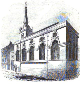
St. Michael Queenhithe was a church in the City of London located in what is now Upper Thames Street. First recorded in the 12th century, the church was destroyed during the Great Fire of London in 1666. Rebuilt by the office of Sir Christopher Wren, it was demolished in 1876.
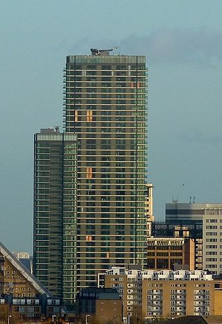
24 Marsh Wall, also known as Landmark East, is a 44-storey residential skyscraper in Docklands, London, which is among the tallest structures in the city. Landmark East is part of a broader residential neighbourhood, The Landmark, also comprising the 30 story Landmark West at 22 Marsh Wall, two adjacent mid-rise apartment buildings, and the Landmark Pinnacle. They sit in a prominent position at the north western edge of the Isle of Dogs, and are very close to the financial center of the Canary Wharf estate, at around 5-10 minutes walk.
Frog Island is a peninsula on the north bank of the River Thames in Rainham, London at grid reference TQ515805. It is used for vehicle storage in Ferry Lane Industrial Estate and for the mechanical biological treatment works building of the East London Waste Authority.

Queenhithe is a small and ancient ward of the City of London, situated by the River Thames and to the south of St. Paul's Cathedral. The Millennium Bridge crosses into the City at Queenhithe.

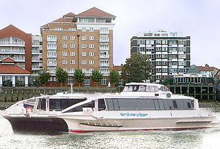
The Canary Wharf – Rotherhithe Ferry is a passenger ferry across the River Thames in the south east of London, England. The service connects Canary Wharf Pier, serving the major Canary Wharf office development north of the river, with Doubletree Docklands Nelson Dock Pier at the DoubleTree Docklands Hotel in Rotherhithe.

Queen Victoria Street, named after the British monarch who reigned from 1837 to 1901, is a street in London which runs east by north from its junction with New Bridge Street and Victoria Embankment in the Castle Baynard ward of the City of London, along a section that divides the wards of Queenhithe and Bread Street, then lastly through the middle of Cordwainer ward, until it reaches Mansion House Street at Bank junction. Beyond Bank junction, the street continues north-east as Threadneedle Street which joins Bishopsgate. Other streets linked to Queen Victoria Street include Puddle Dock, Cannon Street, Walbrook and Poultry.

The River Peck is a small stream in London that was enclosed in 1823. The stream daylights on the west side of Peckham Rye Park.
St Mary Mounthaw or Mounthaut was a parish church in Old Fish Street Hill in the City of London. Of medieval origin, it was destroyed in the Great Fire of London in 1666 and not rebuilt.
St Peter, Paul's Wharf, was a Church of England parish church in the City of London. It was destroyed in the Great Fire in 1666.

St George Wharf is a riverside development in Vauxhall, Lambeth, London, England, located on the southern bank of the River Thames beside Vauxhall Bridge. Vauxhall Pier is a calling point for Uber Boat by Thames Clippers riverboats RB1, RB2 and RB6 services.

Walbrook Wharf is an operating freight wharf in the Port of London located in the City of London adjacent to Cannon Street station. It has been given safeguarded wharf status by the Mayor of London and the Port of London Authority (PLA).
City Livery Club is a members-only club in the City of London, which was established in June 1914. It is based at Bell Wharf Lane, Upper Thames Street, London EC4R 3TB, in the City of London, a site that it shares with the Little Ship Club.

Charrington Tower, originally called Providence Tower, is a 44-storey 136 m (446 ft) residential tower located in the New Providence Wharf development on the north side of the River Thames in the Blackwall area of east London, completed in 2016.

London Bridge Wharf was a wharf in the City of London located alongside London Bridge, just to the east of the north end of the bridge. It stood below the Adelaide Buildings and their 1925 replacement, Adelaide House. The wharf was constructed on the site of the London Bridge Waterworks, which had been demolished along with Old London Bridge in 1832. It originally handled general cargo and also passenger steamships, such as the vessels of the New Medway Steam Packet Company, which offered daily "sea cruises" along the North Kent and Essex coasts.
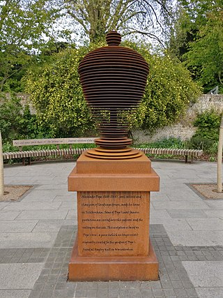
Pope's Urn, on Champion's Wharf at Twickenham riverside in the London Borough of Richmond upon Thames, is a contemporary piece of public art inspired by the poetry of 18th-century Twickenham resident Alexander Pope, who is buried in the parish church that overlooks the wharf. It consists of a stylised urn on a pedestal, both made in corten steel and standing just over eight-foot high, surrounded by wooden benches inscribed with aphorisms written by Pope. It was commissioned to celebrate the 2015 Rugby World Cup, for which Twickenham Stadium was one of the venues, and was opened in a ceremony on 21 September 2015.
