
Grande Prairie is a city in northwest Alberta, Canada within the southern portion of an area known as Peace River Country. It is located at the intersection of Highway 43 and Highway 40, approximately 456 km (283 mi) northwest of Edmonton. The city is surrounded by the County of Grande Prairie No. 1.

Dawson Creek is a city in northeastern British Columbia, Canada. The municipality of 24.37 square kilometres (9.41 sq mi) had a population of 11,583 in 2011. Dawson Creek derives its name from the creek of the same name that runs through the community. The creek was named after George Mercer Dawson by a member of his land survey team when they passed through the area in August 1879. Once a small farming community, Dawson Creek became a regional centre after the western terminus of the Northern Alberta Railways was extended there in 1932. The community grew rapidly in 1942 as the US Army used the rail terminus as a transshipment point during construction of the Alaska Highway. In the 1950s, the city was connected to the interior of British Columbia via a highway and railway through the Rocky Mountains. Since the 1960s, growth has slowed.

Northern Alberta Railways was a Canadian railway which served northern Alberta and northeastern British Columbia. Jointly owned by both Canadian National Railway and Canadian Pacific Railway, NAR existed as a separate company from 1929 until 1981.

The Peace River Regional District is a regional district in northeastern British Columbia, Canada. The regional district comprises seven municipalities and four electoral areas. Its member municipalities are the cities of Fort St. John and Dawson Creek, the district municipalities of Tumbler Ridge, Chetwynd, Taylor, and Hudson's Hope, and the village of Pouce Coupe. The district's administrative offices are in Dawson Creek.

The Peace River Country is an aspen parkland region centring on the Peace River in Canada. It extends from northwestern Alberta to the Rocky Mountains in northeastern British Columbia, where a certain portion of the region is also referred to as the Peace River Block.

Hythe is a village surrounded by the County of Grande Prairie No. 1 in northwestern Alberta, Canada. It is located on Highway 43 approximately 58 km (36 mi) northwest of the City of Grande Prairie and 73 km (45 mi) southeast of the City of Dawson Creek, British Columbia.
Teepee Creek is a hamlet in northwest Alberta, Canada within the County of Grande Prairie No. 1. It is located north of Bezanson and east of Sexsmith, at the intersection of Highway 674 and Highway 733.
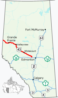
Alberta Provincial Highway No. 43, commonly referred to as Highway 43, is a major highway in northern and central Alberta, Canada that connects Edmonton to the British Columbia border via the Peace Country, forming the northernmost portion of the CANAMEX Corridor in Alberta. It stretches approximately 499 km (310 mi) from Highway 16 near Carvel west of Edmonton to the British Columbia border west of Demmitt. It is designated as a core route in Canada's National Highway System, comprising a portion of a key international corridor that stretches from Alaska into Mexico.

The Municipal District of Greenview No. 16 is a municipal district in northwest Alberta, Canada.

The Wapiti River is a river in eastern British Columbia and western Alberta, Canada. It is a major tributary of the Smoky River, located in the southern area of the Peace River Basin.
Northern Alberta is a region located in the Canadian province of Alberta.
Bezanson is a hamlet in northern Alberta, Canada within the County of Grande Prairie No. 1. It is located approximately 30 kilometres (19 mi) east of Grande Prairie on Highway 43, west of the Smoky River.

Valhalla Centre is a hamlet in northern Alberta, Canada within the County of Grande Prairie No. 1.

The Pouce Coupe River is a major tributary of the Peace River in Alberta and British Columbia, Canada. Its name is officially spelled Pouce Coupé River, but it is commonly written without the acute accent.

The Redwillow River is a tributary of the Wapiti River in northern Alberta and north-eastern British Columbia, Canada. It flows through the Pouce Coupe Prairie, in the south of Peace River Country.

Grande Prairie is a provincial electoral district in Alberta, Canada, that has existed twice, first from 1930 to 1993 and again from 2019. It is one of 87 districts mandated to return a single member (MLA) to the Legislative Assembly of Alberta.

Hazelmere is an unincorporated locality in northwest Alberta within the County of Grande Prairie No. 1. It is located between the Red Willow River and Diamond Dick Creek, approximately 75 km (47 mi) southwest of Grande Prairie.

Alberta Provincial Highway No. 34, also known as Highway 34, was a highway in northwest Alberta, Canada, that existed in various configurations from the mid-1930s to the late 1990s. It was originally established in the 1930s as a 172-kilometre (107 mi) east–west alternative highway to Highway 2 from north of Grande Prairie to Triangle, west of High Prairie, through the southern Peace Country via Valleyview. After a number of realignments affecting the east segment of the highway in the late 1950s through mid-1960s and a shortening in the early 1990s due to highway renumbering, Highway 34 spent its final years as a 105-kilometre (65 mi) highway between Highway 2 north of Grande Prairie to Valleyview before being renumbered as Highway 43 on March 1, 1998.

Central Peace-Notley is a future provincial electoral district in Alberta, Canada. The district will be one of 87 districts mandated to return a single member (MLA) to the Legislative Assembly of Alberta using the first past the post method of voting. It will be contested for the first time in the 2019 Alberta election.

